Such good news for all the people who love the trails at Lake Oroville SRA - THE LAKE IS FULL!
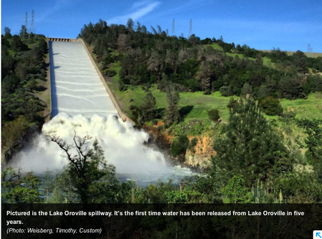
Dozens of people made their way toward Oroville Dam to see water surge down the dam’s controlled spillway Thursday. The 5,000 cfs being released down the concrete spillway is about 37,400 gallons per second. It’s the first time the spillway has been in opened in five years to maintain storage space in Lake Oroville for flood control. Over the past 10 years, the spillway has been open for flood control just twice. Many people parked their vehicles just off of Oro Dam Boulevard East and got out to see the turbulent water cascade down the long concrete chute away from the earthen dam. The water crashed into large blocks at the bottom of the spillway before spilling into the Feather River.
Tamara Wells and David Rapp were among those that stopped by Thursday. Wells said she’s been keeping an eye on the lake level.
“It’s refreshing to see we can finally let some water out,” Wells said.
Rapp said he follows water condition forecasts as a surfer. It’s the most water he’s seen in Lake Oroville, but he knew what the El Niño climate pattern could generate after living in Southern California.
Jeri Finch brought her 10-year-old granddaughter, Lily Wilson, to watch the water on the spillway. Lily said she didn’t think she’s seen the water spill so much before.
“It’s looks like an ocean in there,” she said.
Finch said Lake Oroville is beautiful when the water level reaches the trees. They get tired of looking at the dirt, she said.
“It’s nice to have our lake back again,” Finch said.
Kalin Patel, of Paradise, stopped by with her mother before going to check out the lake. She said the flowing water was more than she expected.
“I’m surprised we have this much water to let down,” Patel said.
RELEASES TO CONTINUEBeginning at 10 a.m., the rate of the water being released increased throughout the day, reaching 6,000 cubic feet per second by 5 p.m., according to information from the state Department of Water Resources. About 5,000 cubic feet per second were sent down the spillway, with the rest going through the Edward Hyatt Powerplant underneath the dam.
The concrete spillway is located on the northwest end of the dam and can reach down to 813 feet. There is an emergency spillway immediately northwest of the concrete spillway, but it has never been used in the dam’s 48 years of operation, according to DWR senior engineer Kevin Dossey.
The 5,000 cfs being released down the concrete spillway is about 37,400 gallons per second, Dossey said.
The water release is the equivalent of flushing 23,375 1.6-gallon toilets every second.
Dossey said earlier this week that the lake hit the flood control reservation limit Saturday when the water level reached 850.12 feet above sea level, less than 50 feet from the crest of 900 feet. The reservation limit may vary between 848.5 feet to 875.5 feet, depending on how wet conditions are in the Feather River basin.
“Because we’re encroached into this space, we’re mandated to release it,” Dossey said Thursday.
The lake stood at 862.42 feet, as of 6 p.m. Thursday. The last time the lake was this high was May 10, 2013, when it was at 862.05 feet.
After discussions with the U.S. Army Corps of Engineers, DWR crews opened the spillway gates Thursday and will keep releasing water through at least Wednesday.
The water release will raise Feather River 2 to 4 feet below the Thermalito Afterbay outlet. The change in the river’s elevation varies on the river’s width at any given point, Dossey said.
The Feather River through downtown Oroville, between the Fish Barrier Dam and the afterbay outlet, will remain stable at 800 cfs.
The flood reservation limits are reduced after April 1. Dam operators will be able to slowly fill the reservoir, but it may be until June 15 before crews will be allowed to potentially fill the lake to the crest.
The latest state projections estimate the lake may reach between 864 to 892 feet, depending on how much precipitation hits the region.
LAKE LEVEL RISESThe opening of the spillgates will clear at least 60,000 acre-feet of water from the reservoir. An acre-foot is 325,851 gallons.
Despite that, Dossey said Lake Oroville will continue to rise because water flowing into the lake still exceeds the outflow.
“The lake will not decrease in elevation, but the rate of rise will decrease,” Dossey said.
On Thursday, officials were releasing up to 6,000 cfs, but the lake was taking in more than 15,000 cfs.
Prior to Thursday, the lake level was increasing about 2 feet per day. Now, the lake will rise about a foot a day.
Overall, the lake has seen a tremendous increase this month — 93 feet. Dossey said marina crews have worked particularly hard as the lake has risen 4 to 5 feet on some days.
The lake has risen 212.91 feet since reaching its seasonal low of 649.51 feet on Dec. 9.
On Thursday evening, the lake was at 84.2 percent of its capacity of 3.5 million acre-feet. It was at 112.7 percent of its historical average for March 24.
HOPES FOR DROUGHTMany of the people that stopped to watch the water flow down the spillway Thursday were optimistic about Lake Oroville’s recovery amid nearly five years of drought.
Peggie Adamson, of Oroville, said it was a major year thanks to El Niño. She believes the lake will reach the top.
“My main concern is that the state uses it wisely instead of wasting it,” Adamson said.
She said Californians have learned a lot from the drought, including how to conserve home water use and to never predict what Mother Nature will do.
Dossey guessed the state couldn’t declare the drought over yet. While north state reservoirs are doing well, including Shasta Lake and Bullards Bar Reservoir in Yuba County, groundwater levels are still down and reservoirs in Central California are still depleted.
“It’s going to take more than one year of good precipitation to bring us out of drought conditions,” Dossey said.
To see the original article and more photos in the Oroville Mercury Register newspaper, CLICK HERE.

 RSS Feed