MOTHER LODE TRAILS
  • Home
  • About
  • Contact
  • Volunteer
  • Links
    • Law Enforcement Emergency
    • Federal, State, County Districts Parks & Trails
    • Running Clubs
    • Equestrian Clubs
    • Mt. Bike Clubs
    • Hiking Clubs
    • Trail Advocacy Organizations
    • Phone Numbers State & Federal Parks, Trails & Lands
    • Where to Eat on the Trails
  • News
  • Alerts

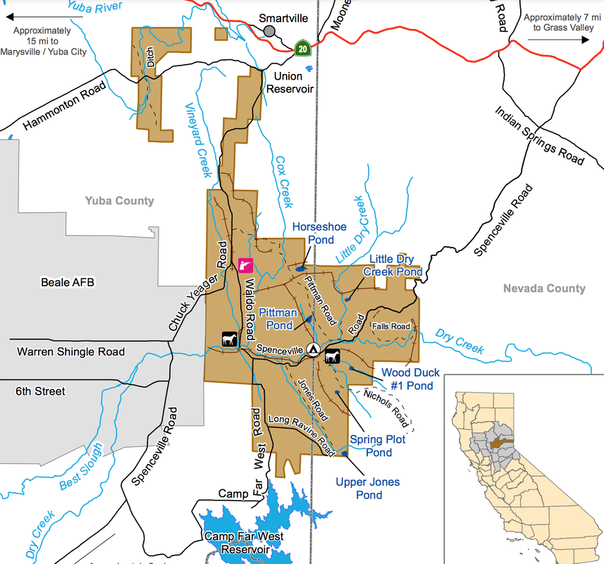
Prescribed burns at Beale to affect Spenceville Wildlife Area

5/26/2021

 
Picture
The Beale Fire Department and on-base Wildland Support Module will be conducting prescribed burns on base between May 27 and June 11.

Approximately, 3,255 acres of prescribed burning is scheduled to take place between these dates with the most significant prescriptive burn occurring on June 5. During this burn, 2,175 acres will be targeted and smoke will be visible coming from Beale Air Force Base during this time period.

Burns will start between 8 a.m. and 10 a.m. pending on weather conditions and will continue into the afternoon. Smoke will be visible from Highway 20, Browns Valley, Smartsville, Wheatland, Linda and surrounding communities.

For the June 5 burn, California Air Resources Board and Feather River Air Quality Management District will mobilize air monitoring stations and monitor potential smoke impacts throughout the surrounding communities. In addition, multiple fire agencies will be assisting Beale’s Fire Department with the ignition and control of the largest burn.

These fire agencies includes the Fire Departments from Wheatland, Linda, Marysville, and Smartsville, the U.S. Forest Service, CALFIRE, and two United States Air Force Wildland Support Modules from Joint Base Charleston and Vandenberg.

Prescribed burns aim to reduce the threat of wildland fire by minimizing vegetative fuel loading, as well as reduce invasive plants and weeds in order to promote an increase in native grasses. The Air Force will only initiate the burns with favorable weather conditions including humidity, temperature, wind speed and direction, and moisture in the vegetation. Fire crews conduct small test fires before igniting the larger area to verify how effectively vegetation (fuels) will be consumed to ensure the burn and smoke management objectives can be met. Beale’s Air Quality Manager and Wildland Fire & Fuels Specialists is working diligently and in close coordination with the California Air Resources Board and Feather River Air Quality Management District to minimize smoke impacts to the surrounding communities.

During active fire operations, fire personnel and apparatuses working in these vicinities will be visible to the public. Motorists are reminded to slow down and drive with heightened caution when passing through active prescribed burn areas.

Firefighters working in fire teams will work to control the fire’s intensity and ensure the fire progresses in a safe manner. Resources will continue to check the area for several days following the fires.

Questions regarding prescribed burns can be directed to 9th Reconnaissance Wing Public Affairs at [email protected] or 530-634-8887.

To see the original article in the Defense Visual Information System CLICK HERE.

Comments are closed.

    Archives

    June 2025
    May 2025
    April 2025
    March 2025
    February 2025
    January 2025
    December 2024
    November 2024
    October 2024
    September 2024
    August 2024
    July 2024
    June 2024
    May 2024
    April 2024
    March 2024
    February 2024
    January 2024
    December 2023
    November 2023
    October 2023
    September 2023
    August 2023
    July 2023
    June 2023
    May 2023
    April 2023
    March 2023
    February 2023
    January 2023
    December 2022
    November 2022
    October 2022
    September 2022
    August 2022
    July 2022
    June 2022
    May 2022
    April 2022
    March 2022
    February 2022
    January 2022
    December 2021
    November 2021
    October 2021
    September 2021
    August 2021
    July 2021
    June 2021
    May 2021
    April 2021
    March 2021
    February 2021
    January 2021
    December 2020
    November 2020
    October 2020
    September 2020
    August 2020
    July 2020
    June 2020
    May 2020
    April 2020
    March 2020
    February 2020
    January 2020
    December 2019
    November 2019
    October 2019
    September 2019
    August 2019
    July 2019
    June 2019
    May 2019
    April 2019
    March 2019
    February 2019
    January 2019
    December 2018
    November 2018
    October 2018
    September 2018
    August 2018
    July 2018
    June 2018
    May 2018
    April 2018
    March 2018
    February 2018
    January 2018
    December 2017
    November 2017
    October 2017
    September 2017
    August 2017
    July 2017
    June 2017
    May 2017
    April 2017
    March 2017
    February 2017
    January 2017
    December 2016
    November 2016
    October 2016
    September 2016
    August 2016
    July 2016
    June 2016
    May 2016
    April 2016
    March 2016
    February 2016
    January 2016
    December 2015
    November 2015
    October 2015
    September 2015
    August 2015
    July 2015

    Categories

    All

    RSS Feed

Home
Contact
 Mother Lode Trails is YOUR local volunteer-run trail information and resource website. Here you can find
up-to-the minute information on trail alerts, links and trail news for Placer,  Yuba, and Nevada counties.
Mother Lode Trails is trademarked.