Beginning today, most of the Caldor fire area in the Eldorado National Forest will again be open for public access. Visitors are reminded to use extra caution when recreating in this part of the forest due the hazards in recently burned landscapes.
Forest Service reopens El Dorado National Forest dirt roads
The seasonal closure of native surface roads (also known as dirt roads) in the Eldorado National Forest will be lifted beginning Friday April 1, 2022. However, damage could still occur from using dirt roads in wet areas and visitors will be responsible for any damage caused by inappropriate use.
Due to melting snow, wet areas will still be present in the forest, especially at higher elevations. Many routes change in elevation over several miles. Visitors are encouraged to be aware of changes in the conditions of the roads they are using, and to adjust travel plans if they reach a wet section.
The seasonal closure is designed to protect roadbeds and watersheds from damage and to protect water quality. A minimum three month closure period from January 1 through March 31 was designated for the core part of the wet season in the Eldorado National Forest Travel Management Plan. This plan also allows the seasonal dirt road closure to start earlier or be extended based on actual conditions in a given year.
The seasonal closure does not affect routes in the Rock Creek Area near Georgetown, which has its own wet weather route closure process.
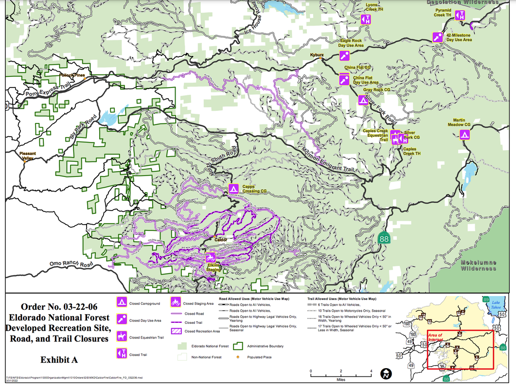
The following roads, trails and developed recreation sites directly impacted by the fire will remain closed for ongoing hazard mitigation under Forest Order 03-22-06:
STILL CLOSED
Elkins Flat OHV Trail System
11N46 (Alder Creek Road)
10N40 (Plum Creek Road)
42 Milestone Day Use Area
Caples Creek Trailhead
Caples Equestrian Trailhead
Capps Crossing Campground
China Flat Campground and Day Use Area
Eagle Rock Day Use Area
Elkins Flat OHV Staging Area
Gray Rock Campground
Lyons Creek Trailhead
Martin Meadows Campground
Pyramid Creek Trailhead
Silver Fork Campground
CLICK HERE to see the original article in Gold Country Media.
CAN YOU HELP RESTORE SOME OF THE CALDOR FIRE TRAILS? YES!
CLICK HERE FOR THE CALDOR TRAILS RESTORATION FUND
The Caldor Fire raged through an area containing some of the region’s favorite trails. The fire burned many parts of trails, bridges and trail infrastructure. Between damage from fire itself, as well as from dozers constructing suppression lines, more than 15 miles of trail suffered damage in the Tahoe Basin.
Areas that burned hottest will be prone to increased damage from winter storms due to lack of vegetation and hydrophobic soils which can contribute to debris flows and landslides. We will need to rebuild the damaged infrastructure as well as mitigate the potential for increased runoff by installing erosion control measures.
We are working closely with the US Forest Service, TAMBA, and the Tahoe Rim Trail as they access the impact and the support that will be needed to rebuild and restore the trails.
Join us in restoring our forest and rebuilding our trails in the aftermath of this devastating fire.
 RSS Feed