MOTHER LODE TRAILS
  • Home
  • About
  • Contact
  • Volunteer
  • Links
    • Law Enforcement Emergency
    • Federal, State, County Districts Parks & Trails
    • Running Clubs
    • Equestrian Clubs
    • Mt. Bike Clubs
    • Hiking Clubs
    • Trail Advocacy Organizations
    • Phone Numbers State & Federal Parks, Trails & Lands
    • Where to Eat on the Trails
  • News
  • Alerts

Trail advocacy group hires attorney to challenge the newly released Folsom Lake SRA trails plan

1/31/2023

 
Picture
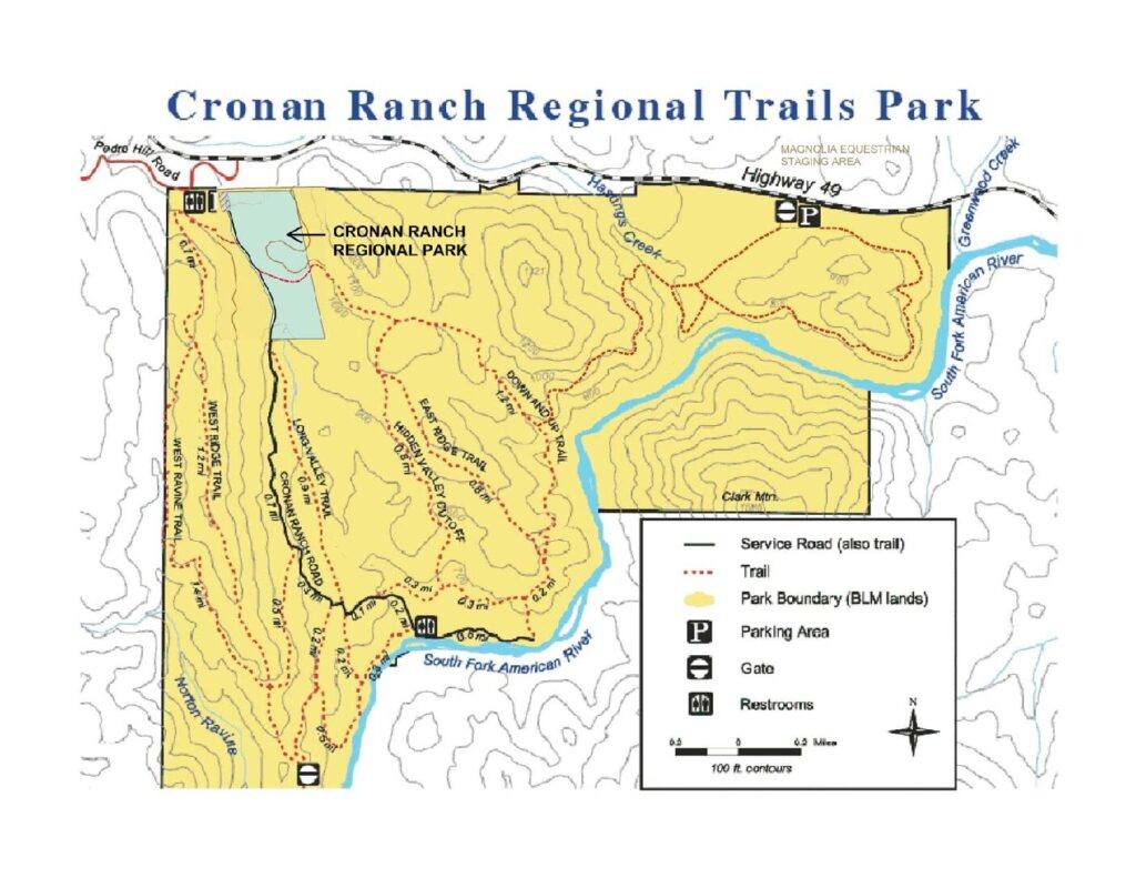
Action Coalition for Equestrians has been revived by a new group, Ace4SafeTrails. They will be covering California State Parks trails, at this time, particularly Folsom Lake SRA.  Ace4SafeTrails have expanded who they represent to include all the foot trail users; hikers/walkers as well as equestrians. 

Ace4SafeTrails have dedicated a webpage on their website to explain their actions regarding the
 Folsom Lake State Recreation Area Road and Trail Management Plan (RTMP), stating that State Parks has filed a misleading negative declaration for the new trails plan in their official statements. About the new Plan permitting bikes on previous hiker/horse foot trails, State Parks stated: 
“No issues were raised by the agencies or the public.”
Ace4SafeTrails says that the State Parks Negative Declaration ignored hundreds of letters, phone calls and emails concerned about trail safety by adding fast bikes to the narrow hiker/horse trails.

In addition to the Negative Declaration, Ace4SafeTrails is objecting to the "Change in Use" plan to convert many more miles of hiker/horse trails to bike trails. The "Change in Use" is put into action by public requests. 
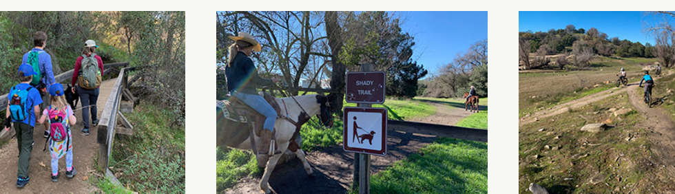
​

"
We are very concerned that Folsom Lake State Park’s recently announced “Change-In-Use” plans to convert many existing single track trails into “multi-use trails” will create very dangerous and unpleasant conditions for all trail users. State Park’s Trail Plan to combine all fast moving and slow moving trail users onto the same trails will ruin the relaxing, stress relieving experience most trail users seek as they explore and enjoy nature in State Parks."
 
Ace4SafeTrails has provided several solutions that State Parks have not considered in their Plan, including one that the biking community seems to embrace: separate trails for slow (hikers/horses) and for fast (mt. bikes) users. 

Ace4SafeTrails.org Facebook page will be regularly updating the public concerning their legal actions. They want State Parks to ensure trail safety for the slower users on the hiking/horse trails instead of permitting fast and racing bikes new access endangering the slower trial users. 


CEQA and Plan are complete for Folsom Lake SRA and Folsom Powerhouse SHP Road and Trail Management Plan

1/30/2023

 
Picture
From Folsom Lake SRA Administration:
​The Folsom Lake SRA and Folsom Powerhouse SHP Road and Trail Management Plan (RTMP) and Initial Study/ Negative Declaration (IS/ND) CEQA are complete.

Thank you for your participation in this process. State Parks looks forward to working with the public on the future implementation of recommendations in the RTMP.

The Documents include:
  • Folsom Lake SRA and Folsom Powerhouse SHP Final RTMP (January 20, 2023)
  • Folsom Lake SRA and Folsom Powerhouse SHP RTMP Final Appendices (January 20, 2023)
  • Folsom Lake SRA and Folsom Powerhouse SHP RTMP Draft IS/ND (Sept 21st version)
  • Folsom Lake SRA and Folsom Powerhouse SHP Final Initial Study/Negative Declaration with Revisions and Responses to Comments (January 20, 2023).
  • This document contains the following:
    • Master responses to comments received during the CEQA review period
    • Responses to individual comments received during the CEQA review period
    • Revisions to Draft IS/ND (Sept 21st version)
    • Revisions to Public Draft RTMP (Sept 21st version)
    • ​
  • Appendix A: Comment Letters (all letters, in full)


CLICK HERE to go to State Parks Plans page.

Folsom Lake SRA Horse Assembly and other areas closure alert for Jan. 28, 2023

1/27/2023

 
Picture
North Granite Bay will be closed Saturday, January 28th, morning until 11am for an event. This includes everything north of the Horse Assembly area, Oak Point, Dotons Point, and Beeks Bight. Please plan accordingly and have a great weekend!

Go here for updates on the FLSRA Facebook page

Placer County Board of Supervisors approves eight Tahoe projects, including improvements to six trails

1/25/2023

 
Picture
TAHOE CITY, Calif. – Eight capital improvement projects have received funding in eastern Placer County, based on the recommendation of the Capital Advisory Projects Committee. At Tuesday’s meeting, the Placer County Board of Supervisors unanimously approved the allocation of approximately $4.49 million in tourism occupancy tax dollars to help fund the eight projects for the 2022-23 fiscal year.

Projects funded in this grant cycle feature improvements to portions of the Resort Triangle Trail, including the Martis Valley Trail ($2 million), Flick Point II Trail ($70,000) and the North Tahoe Trail ($1.5 million). Additional dirt trails and amenities were also funded including Sawtooth Trail ($157,983), Donner Lake Rim Trail ($265,000) and Cabin Creek trailhead amenities ($91,694).

The CAP Committee is co-convened by Placer County and the North Tahoe Community Alliance, formerly known as the North Lake Tahoe Resort Association. The committee is tasked annually with making recommendations to the Placer County Board of Supervisors for grant awards to fund infrastructure and capital projects. The committee includes 13 appointed members representing eastern Placer County businesses, special districts, ski resorts, the North Lake Tahoe Resort Association and Placer County.

CLICK HERE to see the original and complete article in the Sierra Sun Newspaper.

Placer Supervisors approve plans for Hidden Falls Twilight Ride

1/25/2023

 
Picture
The Placer County Board of Supervisors approved plans for a Twilight Ride Public Well project, which will serve the first phase of the Hidden Falls Regional Park Trails Expansion Project, during its consent agenda Tuesday.

The expansion project, which was approved by the board on March 8, 2021, in a 3-2 vote, proposes to expand the regional park to 3,395 acres, including doubling the trail network from 30 to 60 miles and adding vehicle, ADA and equestrian parking. The project also includes the construction of supportive facilities such as viewing platforms, benches, stream crossings and fire suppression facilities.

The board’s recent approval verifies the adequacy of a public well. The staff report notes the well will serve a prefabricated flush restroom building and the approval provides the Department of Parks and Open Space with the authority to advertise for construction bids, award a bid and execute a contract. The cost of the well is projected at $110,000.

According to the staff report, provisions of the first phase of the expansion include a restroom and parking lot at 5345 Bell Road that will provide 54 vehicle parking stalls and 20 equestrian stalls.
​
​The cost for Phase 1 is slated at $3.9 million, paid for by a $3.02 million Prop. 68 grant provided by the California Natural Resources Agency and $934,200 in county-matching funds allocated from the General Fund and Park Dedication Fees.


CLICK HERE to see the original article and photos in Gold Country Media.


After Mosquito Fire and Heavy Rains, Western States Trail Requires Serious Work and threatens the famous races

1/23/2023

 
Picture
California's largest fire of 2022 never quite grew to a tenth of the size of 2021's nearby Dixie fire, but that isn’t to say it did not have an oversized impact.

Over 46 days spanning a portion of September and October, the Mosquito Fire burned more than 76,000 acres of forest from the town of Foresthill up to the edge of the Sierra Crest near Olympic Valley, costing state and federal fire agencies $181 million in firefighting salaries and resources. Beyond the monetary cost of the fire, far greater impacts were felt in the surrounding communities, including the loss of 78 structures and residual effects to livelihoods. The U.S. Forest Service (USFS) has focused a lot of its efforts on recreational infrastructure because of its economic importance in the area. The USFS has since performed an internal study to quantify the impacts of the wildfire, and related these findings to local stakeholders including residents and businesses.

Existing within the boundaries of the Mosquito Fire is the Western States Trail, specifically, the 12.4 miles between Last Chance and Michigan Bluff, often known as the "canyons" of the Western States 100 course--one of the most well-known sections of the course. This relatively short section of trail ascends 5,226 feet and descends 6,406 feet, cresting at Devil's Thumb, traversing over 36 switchbacks, and passing Deadwood Cemetery that hosts the remains of the miners and Chinese laborers who built this trail, once among a litany of trails developed by the Washoe people that lived on this land, in the late 1850s.

Thankfully, for those chasing a golden ticket entry or already accepted into this year's race, the staff at Western States has been communicating with the USFS since the beginning of the blaze and have been "working full-time on getting the trail open ever since," said Craig Thornley, Western States race director. Thornley says an agreement has been reached between the race and the USFS, to leverage private funds in order to repair the trail and open in time for the late June race. This is anything but the normal or anticipated result, Thornley said.

"Both races I direct, the Waldo 100K and Western States, were impacted by wildfire in 2022, and that was in a relatively light fire year," he says. "What most race directors appear to do is take the approach of waiting for land managers to tell them when the trail can be used again. In this case we were front and center, asking: 'what do we need to do to get this open?' If we hadn’t, it could be several years until the race would be feasible."

This work had, up until the December holiday break, included a number of volunteer days aimed at adding water bars and other trail fortifications to reduce erosion impacts from typical winter rains. These volunteer days were made feasible, in large part, thanks to the quick action of the USFS Burned Area Emergency Response (BAER) teams, which typically address wildfire areas to fell hazard trees and create plans for restoration work.

Wildfire had impacted this trail in the past, most notably during the American Fire of 2013, lending the Western States team experience as to how to ensure the event would go forward. Also, the 2008 Western States 100 was canceled because of poor air quality, due to numerous wildfires in the area.

Based on the efforts made last fall, Thornley believed the trail would re-open in plenty of time for the race this June. But that confidence was shaken at the end of December, when a number of atmospheric rivers crossed the Pacific Ocean and dumped heavy precipitation in California.

On the evening of January 5, 2023, a forest order was issued by the Tahoe National Forest, noting extreme damage to the burned sections of both Western States Trail and Mosquito Ridge Road, a key artery to access aid stations in this stretch. Due to the damage, the USFS issued an access closure until December 31, 2023, which would threaten the possibility of this year's race happening. In most cases, this closure would last until the USFS accrued funding and fully repaired the trail and road, which typically takes two to four years, with orders being renewed each calendar year, depending on the forest region budget.

The Western States team is confident that the order will be reversed once trail maintenance is completed. However, due to USFS budgetary constraints, this trail maintenance will be funded by private donors through the Western States nonprofit structure, on the behalf of the government, a strong partnership and plan between event promoters and land managers.

While it is impressive that the Western States staff has been able to, in all likelihood, stave off race cancellation or delay, there is a larger question to ask: what do individuals, race promoters, and sponsoring brands do under the face of rising hazards in the present and future?

Firefighters from across California battled flames of the fast-moving Mosquito Fire in Volcanoville of California, United States on September 11, 2022. (Photo by Tayfun Coskun/Anadolu Agency via Getty Images)In California, the Santa Ana winds have driven wildfires followed by rain events for centuries, but climate modelers warn that the number and severity of wildfires of the past several years, as well as the frequency of high-severity extreme precipitation events, highlight a worsening climate trend.

No longer is climate change and public land management solely impacting individual communities for discrete periods of time. It is also placing a serious threat to the start line of arguably the most lauded trail running event in North America. The burning of one trail, which will likely require hundreds of thousands of dollars to restore and treat for public safety, is forcing the hand of major race promoters, and the entire outdoor industry, to consider where climate change fits in their yearly budgets.

While the question as to what Western States runners should expect this year is clearly front and center, most see the writing on the wall--the industry must adapt to and address climate change. Fortunately, Western States will almost assuredly happen this year, but only because of the immense work ethic, generous donor giving, and long-term community building of the event staff.

While Western States has the funding to avert disaster this year, both Canyons Endurance Runs by UTMB and the Tevis Cup equestrian event are held in April and July, respectively, on the same trails. There is no guarantee the trail will be open and usable as early as April, or in good condition for horses by July. At the time of publication, UTMB staff were in communication with Western States and land managers to find solutions for Canyons in 2023. However, no official statement has been issued at this time.

Of course, these three races alone are not the first to be impacted by both natural disasters and a limited federal budget for trail restoration. For example, in the last decade, Santa Barbara's Nine Trails has seen the same cascading disaster chain. Such complications have also been experienced along trail systems in Flagstaff, Arizona, Glenwood Springs, Colorado, and across the Pacific Northwest.

Thornley credits the decade-long relationship building with the USFS, California State Parks, and private landowners for their ability to quickly avert closure, noting the volunteer trail work days and private fundraising the event has done in collaboration with these land managers over the years. Western States has acted as an exemplar for other events to emulate in the coming decades, under a shifting climate system. However, one must ask whether other trail running event organizers have considered the time necessary to build these relationships with land managers, and to make plans accordingly before the next natural disaster strikes. The future of the sport depends on the urgent planning and trust-building of these various stakeholders.

CLICK HERE to see original article in the Trail Runner.
​

Tahoe National Forest hiring recreation staff for 2023 season

1/14/2023

 
Picture
NEVADA CITY, CALIF. — Tahoe National Forest is now hiring temporary and seasonal recreation staff to fill a variety of positions. Seasonal jobs help Tahoe National Forest achieve its mission by contributing to forest health, resource protection and public recreation infrastructure. Interested applicants are invited to apply by Jan. 19, 2023. 

“Seasonal staff are vital to maintain Tahoe National Forest’s robust recreation program,” said Recreation Officer Hillary Santana. “If you have a passion for outdoor recreation, land stewardship and customer service, these jobs are for you! Seasonal staff are the glue that hold our recreation program together and allow us to continue offering so many recreation opportunities for our public.” 
There are several duty locations across the forest including Camptonville, Foresthill, Grass Valley, Nevada City, Sierraville and Truckee. Positions range from trail construction to campground maintenance and monitoring: 
  • Forestry Aid (Recreation) 
  • Forestry Technician (Recreation) 
  • Forestry Technician (Wilderness/Trails) 
  • Laborer (Road Crew) 
  • Maintenance Worker  


Individuals interested in working outdoors in the beautiful Sierra Nevada are encouraged to learn more about these seasonal opportunities at 
https://www.fs.usda.gov/detail/tahoe/about-forest/jobs/?cid=fseprd1083975

Tahoe National Forest is also recruiting both permanent and seasonal wildland firefighters. The Forest Service will be hosting hiring events for interested applicants. 

To see the original article in YubaNet.com, click here.


Cronan Ranch Development meeting Feb. 2, 2023

1/14/2023

 
Picture
Come to a Cronan Ranch information gathering meeting.
February 2, 2023  - 5:30pm
Coloma Grange
319 CA-49
Coloma, CA 95613

This meeting will precede the Cool-Pilot Hill Advisory Committee meeting. There will be presentations by the equestrian and mountain bike communities as well as the Native Plant society relative to the development of the county-owned, 64-acre Cronan parcel.

​Please come to learn more about the equestrian options for the property and support the trail using public.

Experimental Forest trail completely blocked by downed trees.

1/10/2023

 
Picture
The trail through the experimental forest is completely blocked by a dead downed Ponderosa pine. It's located just west of the bald eagle nest. A rider tried to go over a couple trees just in the edge of the planted area, but there were too many down across the trail.

High winds, more rain, falling trees a danger on trails

1/10/2023

 
Picture
The National Weather Service has issued a Flood Advisory, High Wind Warning, and Flood Watch for areas of Nevada and Placer counties. (photo of tree down on American River Parkway trail that trapped a hiker.)
The High Wind Warning warns of "damaging winds" that could "blow down trees and power lines."
The Flood Watch last through Wednesday afternoon and warns that "excessive runoff may result in flooding of rivers, creeks, streams and other low-lying and flood prone locations."
Today will be breezy, with a south wind of 23 to 28 mph decreasing to 11 to 16 mph in the afternoon. Gusts as high as 55 mph could be possible. Between 1 and 2 inches of new precipitation amounts could fall today. The rain will be heavy at times and snow in the mountains.
More rain and snow is expected Tuesday, along with a possible thunderstorm after 11 a.m. Between 1 and 2 inches is possible again. 
Wednesday will be mostly cloudy with a 60% chance of rain, mainly after 11 a.m. The high should be near 47 and the low around 41. Southeast wind around 8 mph is possible.
<<Previous

    Archives

    March 2023
    February 2023
    January 2023
    December 2022
    November 2022
    October 2022
    September 2022
    August 2022
    July 2022
    June 2022
    May 2022
    April 2022
    March 2022
    February 2022
    January 2022
    December 2021
    November 2021
    October 2021
    September 2021
    August 2021
    July 2021
    June 2021
    May 2021
    April 2021
    March 2021
    February 2021
    January 2021
    December 2020
    November 2020
    October 2020
    September 2020
    August 2020
    July 2020
    June 2020
    May 2020
    April 2020
    March 2020
    February 2020
    January 2020
    December 2019
    November 2019
    October 2019
    September 2019
    August 2019
    July 2019
    June 2019
    May 2019
    April 2019
    March 2019
    February 2019
    January 2019
    December 2018
    November 2018
    October 2018
    September 2018
    August 2018
    July 2018
    June 2018
    May 2018
    April 2018
    March 2018
    February 2018
    January 2018
    December 2017
    November 2017
    October 2017
    September 2017
    August 2017
    July 2017
    June 2017
    May 2017
    April 2017
    March 2017
    February 2017
    January 2017
    December 2016
    November 2016
    October 2016
    September 2016
    August 2016
    July 2016
    June 2016
    May 2016
    April 2016
    March 2016
    February 2016
    January 2016
    December 2015
    November 2015
    October 2015
    September 2015
    August 2015
    July 2015

    Categories

    All

    RSS Feed

Home
Contact
 Mother Lode Trails is YOUR local volunteer-run trail information and resource website. Here you can find
up-to-the minute information on trail alerts, links and trail news for Placer,  Yuba, and Nevada counties.
Mother Lode Trails is trademarked.