MOTHER LODE TRAILS
  • Home
  • About
  • Contact
  • Volunteer
  • Links
    • Law Enforcement Emergency
    • Federal, State, County Districts Parks & Trails
    • Running Clubs
    • Equestrian Clubs
    • Mt. Bike Clubs
    • Hiking Clubs
    • Trail Advocacy Organizations
    • Phone Numbers State & Federal Parks, Trails & Lands
    • Lost & Found on the Trails
    • Where to Eat on the Trails
  • News
  • Alerts

Outdoor Access for All: California Establishes New Programs to Expand Youth FREE Access to State Parks

7/31/2021

 
Picture
California State Park Adventure Pass gives fourth graders in the state free annual pass to 19 California State Parks and State Library Parks Pass provides free day-use state park passes to libraries across California for library cardholders
SACRAMENTO — Today, Governor Gavin Newsom signed legislation to advance the state’s commitment to equitable access to California State Parks. Championed by First Partner Jennifer Siebel Newsom, whose California for ALL Kids initiatives support children’s physical, mental, and social-emotional well-being, the legislation establishes a pilot program to give every fourth grader a free annual pass to select California State Parks.

“Nature is a public good and a crucial public health tool. For adults and children alike, quality time in nature is good for our hearts, minds, and bodies,” said First Partner Jennifer Siebel Newsom. “No state is better-positioned than California to leverage the great outdoors to augment our communities’ health and well-being — especially for youth in underserved communities.”

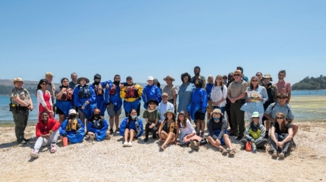
Photo 1: First Partner Jennifer Siebel Newsom with students from Environmental Traveling Companions. Photo courtesy of California State Parks Foundation. Photo 2: First Partner Jennifer Siebel Newsom and Armando Quintero, Director of the California Department of Parks and Recreation with parks access advocates and students. Photo courtesy of California State Parks.

AB 148 establishes the California State Park Adventure Pass, a three-year pilot program that waives day-use entrance fees to 19 state parks for fourth graders and their families for a full year. Earlier this month, the Governor also signed SB 129, legislation that includes $5.6 million to fund the new State Park Adventure Pass as well as $3 million to establish the State Library Park Pass, a new two-year pilot program to provide state park passes to libraries across the state that may be checked out by library patrons to gain free day-use access to state parks.

“Access to nature is a crucial component to the health and well-being of our kids, and these outdoor access pilot programs set us on a path to expand access to nature and benefit children’s health,” said California Natural Resources Agency Secretary Wade Crowfoot. “I am very excited to continue working with the First Partner and California State Parks to reduce barriers and expand access to state parks for kids and residents from park-poor communities.”

In 2019, the First Partner and the California State Parks Foundation launched Pathways to Parks, an initiative to bridge the nature gap and expand park access for California youth. Since then, the First Partner has met with California youth, state parks advocates, and community leaders to learn more about the positive impacts the outdoors has on young people’s physical and mental health.

According to a recent report, 70 percent of low-income communities across the country live in nature-deprived areas. Studies indicate that access to parks and greenspace can lead to improvements in childrens’ physical well-being, social emotional learning, and academic outcomes, with children experiencing reduced stress and demonstrating more enthusiasm for school. One study found that every $1 invested in trails for physical activity led to $2.94 in medical benefits.

“With the leadership of the Governor and First Partner, California was able to create for the very first time innovative access programs for children and families to explore state parks,” said California State Parks Director Armando Quintero. “More diverse communities will have the opportunity to become part of California’s landscape, enjoy the physical and mental benefits of connecting with nature, and be inspired to take care of these treasured places for future generations. We look forward to the continued partnership with the Administration and Legislature.”

With 280 state park units, over 340 miles of coastline, 970 miles of lake and river frontage, 15,000 campsites, and 4,500 miles of trails, the California Department of Parks and Recreation contains the largest and most diverse recreational, natural, and cultural heritage holdings of any state agency in the nation.
For the full text of AB 148, visit: 
https://leginfo.legislature.ca.gov/faces/billNavClient.xhtml?bill_id=202120220AB148

For the full text of SB 129, visit: 
https://leginfo.legislature.ca.gov/faces/billNavClient.xhtml?bill_id=202120220SB129


To see the original post and photos, CLICK HERE.


With waterline at new lows, State Parks Reminds Visitors to Preserve Historic Sites at Folsom Lake State Recreation Area

7/26/2021

 
Picture
California State Parks is urging visitors to Folsom Lake State Recreation Area (SRA) to help protect historic resources by not handling, removing, or destroying artifacts or ruins along the lakebed. Artifacts once belonging to immigrants seeking fortune along the American River are now exposed due to historic low-water levels. These sites and artifacts are protected by both federal and state laws that prohibit disturbing the sites in any way, including removing or relocating artifacts.
(Photo credit: Carl Brunberg)

The land at the bottom of Folsom Reservoir may be covered with as much as 480 feet of water during a wet year, but following dry years, some areas that are normally submerged become exposed, giving a glimpse into its rich historic past.

“It is a unique experience to visit the remains of a historic site and wonder when it was used and how people lived there,” said Folsom Lake SRA Superintendent Richard Preston-LeMay.  “If these historic objects are moved or removed, this experience is ruined for others.”

The present floor of the Folsom Reservoir was used for gold mining and farming for more than 100 years before the Folsom Dam was built. Many of the early settlements were destroyed to allow the filling of Folsom Reservoir in 1955-1956, but reminders of the past remain in the form of foundations and thin scatterings of historic, archaeological artifacts at the bottom of the reservoir. State Parks and its partner, the Bureau of Reclamation, are urging visitors to help protect these artifacts by leaving all objects where they are found.

It is important to protect exposed historic resources by not digging, handling, or removing anything from the lakebed as prescribed by state and federal law. Furthermore, metal detectors are prohibited as stated in the Superintendent’s Order. The historic sites around the lake and those that are normally covered by water in the reservoir are also protected by the Archeological Resources Protection Act (ARPA) and other federal laws. Under the ARPA, fines of up to $250,000 or even imprisonment could be imposed for removing artifacts.

For more information on Folsom Lake SRA, call the Gold Fields District Office at (916) 988-0205. For additional information on the protection of culture resources on federal land managed by Reclamation, please contact Melissa Ivie at their California-Great Basin Regional Office at (916) 978-5028 or mivie@usbr.gov

To see the original article in Yubanet.com, CLICK HERE.
​
​

UPDATES: Penn Gate and Hardrock trails in Empire Mine SHP reopened

7/20/2021

 
Picture
UPDATE: July 19, 2021, Monday, 1:30 PM Penn Gate parking and Hardrock trails are reopened.

UPDATE: July 19, 2021, Monday, 10:15 AM. Sierra District Superintendent's Order posted that Penn Gate parking/staging, the Hardrock trail and trail segments are closed until further notice. See Below.


UPDATE: July 18, 2021 Sunday at 2:26 PM - From Yubanet.com  - Penn Gate parking and the Hardrock trails are still closed due to Friday night’s vegetation fire. Osborn Hill and Union Hill trails are open, as is the historic core of the Empire Mine. Several hazard trees are in the area – please respect the closures.

UPDATE: 1:00 PM Saturday - the Empire Mine office said that the Penn Gate parking lot and trail head and some trails are still closed. No estimated time of opening.

UPDATE:
 10:20 am Saturday - the Empire Mine office said that the Hardrock trail is closed from the Penn Gate trailhead to the Osborne Y. The Penn Gate parking lot will be closed until they finish mopping up and cleaning the area.

From YubaNet.com: 
July 17, 2021 at 1:07 AM Extinguishing hot spots and mop-up operations will take about an hour. Fire is contained and has been mapped at 0.7 acres.
July 17, 2021 at 12:58 AM Firefighters are making good progress on the Auburn incident, forward progress has been stopped at 1-2 acres. Hose line around the fire is complete.
July 17, 2021 at 12:48 AM First water tender has arrived, 6 engines are at scene of the Auburn incident and the dozer is arriving.
July 17, 2021 at 12:44 AM Auburn IC is requesting a second water tender.
July 17, 2021 at 12:36 AM The fire is burning at a slow rate of spread in an easterly direction with very little potential for growth. IC is requesting one water tender to stage at the Penn Gate,
July 17, 2021 at 12:30 AM Law enforcement is departing from the Auburn incident. The IC states the fire is in the burn scar of the previous Auburn fire. Requesting a hand crew and a dozer.
July 17, 2021 at 12:25 AM Units at scene have made access from Empire Mine State Park and the Penn Gate. They estimate the fire to be approximately 2 acres. All units to continue in via East Empire.
July 17, 2021 at 12:22 AM Firefighters have made access on the South Auburn Street side, also staging at Whiting Street. There is no immediate threat to any structures.
July 17, 2021 at 12:14 AM Small spot on fire reported in an empty lot on the 600 block of South Auburn Street in Grass Valley. Law enforcement and fire are at scene.


Picture
Picture

Due to excessive heat, Hidden Falls CLOSED Sunday, July 18, and Monday, July 19

7/18/2021

 
Picture
In response to the excessive heat warning issued by the National Weather Service, Hidden Falls Regional Park will be closed Sunday, July 18th and Monday July 19th.

CLICK HERE to see updates on the Hidden Falls Facebook page.

Beckwourth Complex Fire closes Plumas National Forest

7/10/2021

 
Picture
"This order is being implemented to provide for public safety during emergency circumstances related to ongoing wildfires and extreme fire danger," they said in a statement on their Facebook page. 
The forest closure will be in effect from July 8 through August 1. 
Evacuations underway in Plumas, Lassen counties
The Beckwourth Complex Fire in Plumas County has increased to 53,908 acres.More Evacuation Orders Issued For Beckwourth Complex Fire As It Heads across State LinesCampgrounds and homes around Frenchman Lake were under evacuation orders Friday and a nearly 200-square-mile (518-square-kilometer) area of the forest was closed because of the danger, fire information officer Pandora Valle said.
The Beckwourth Complex Fire is made up of two fires. The Sugar Fire and the Dotta Fire.
Fire officials said that the status of evacuations are changing rapidly. 
A Northern California wildfire exploding through bone-dry timber has prompted Nevada authorities to evacuate a border-area community. The Beckwourth Complex — a merging of two lightning-caused fires — headed into Saturday showing no sign of slowing its rush northeast from the Sierra Nevada.
Across the state line, the Washoe County Sheriff’s Office asked people to evacuate a section of Rancho Haven, north of Reno.
Mandatory evacuations have been ordered around Dooley, Big Cove, Frenchman Cove, Frenchmen Village and Frenchman Lake. This includes all campgrounds and residences around the lake and Maddalena. 
An evacuation center has been set up at Portola Baptist Church at 171 Gulling Street in Portola. 
The Plumas National Forest Service issued a forest closure over the Beckwourth Fire Complex and Beckwourth Ranger District Thursday afternoon. 
The forest closure will be in effect from July 8 through August 1. 
Truckee Meadows Fire and Rescue said in a tweet Wednesday that the Beckwourth Complex Fire is more than 50 miles away, but that the smoke is clearly visible from Reno. 
The fire poses no threat to Washoe County residents, they said in a tweet Thursday. Residents in the Cold Springs and Red Rocks regions should remain vigilant and have contingency plans in place. 
​

Picture

BLM increases fire restrictions in the Sierra Nevada foothills

7/1/2021

 
Picture
"The increased restrictions include no campfires, no barbeques, no open fires, regardless of whether in a developed campground."

Due to dry conditions and high wildland fire danger, the Bureau of Land Management Mother Lode Field Office is increasing seasonal fire restrictions beginning on Thursday, July 1 and will remain in effect until further notice. 

The increased restrictions include no campfires, barbeques, or open fires, regardless of whether in a developed campground. Portable stoves with gas, jelled petroleum, or pressurized liquid fuel are still allowed with a valid California campfire permit, available free on-line at 
www.readyforwildfire.org/prevent-wildfire/campfire-safety/ 
and at all BLM, U.S. Forest Service and Cal Fire offices.  

BLM-managed public lands affected by the restrictions are primarily located in Amador, Calaveras, El Dorado, Mariposa, Nevada, Placer, Sacramento, San Joaquin, Stanislaus, Sutter, Tuolumne and Yuba counties. Fire and shooting restrictions will also affect BLM-managed recreational areas along the American, Merced, Mokelumne, South Yuba and Tuolumne rivers.  
California is experiencing drought and an increased risk of wildland fires. Nearly 90 percent of wildfires in the United States are caused by humans. The public is advised to be extremely careful when recreating outdoors and do the following: always carry a shovel and water and check weather forecasts and fire danger ratings before leaving home. The following restrictions/limitations will remain in place until fire dangers subside: 
  • No campfires, barbeques, or open fires, regardless if you are in a developed campground. Portable stoves with gas, jelled petroleum, or pressurized liquid fuel are authorized with a valid California campfire permit. 
  • No target shooting; use of firearms for hunting is still allowed.  
  • No smoking, except within an enclosed vehicle or building, or at a designated developed recreation site.  
  • No tools powered by internal combustion engines (chainsaws, lawn mowers, generators, etc.) off established roads or trails. 
  • No motorized vehicles off established roads or trails. 
  • No fireworks, including “safe and sane” fireworks. 
  • No welding or operating acetylene or other torch with open flame, except by special permit. 
  • No use of explosives, except by special permit. 
For an interactive map and complete list of restrictions, please visit the BLM California Fire Restrictions. For recorded information, call the Mother Lode Field Office Fire and Fuels Hotline at 916-941-3155. Information on how to prevent wildfires can be found at www.readyforwildfire.org/. For specific questions, contact the Mother Lode Field Office at 916-941-3101. 
To read the complete article in YubaNet.com:
​https://yubanet.com/regional/bureau-of-land-management-increases-fire-restrictions-in-the-sierra-nevada-foothills/

Here is the BLM information wildfire website and dashboard for active fires:  
https://www.blm.gov/programs/public-safety-and-fire/fire-and-aviation/regional-info/california/fire-restrictions

Fourth of July Expected to Be Busy in the Eldorado National Forest, but Fireworks are Prohibited

7/1/2021

 
Picture
Placerville, CA… Holiday weekends are always an active time for human caused fire starts, and an important reminder that fireworks are prohibited on public lands – every forest, every campsite, every day. Campfire restrictions are currently in effect due to severe drought conditions and will remain in effect for the duration of the 2021 fire season.

“It is important that we all take responsibility to prevent human caused wildfires”, said Forest Supervisor Jeff Marsolais. “Visitors need to know that all types of fireworks are illegal to possess or discharge in a National Forest. Citations will be issued for violations.”
Most of the recreation facilities in the forest will be open except Hell Hole Campground due to the extensive amount of hazard trees. Westpoint, Yellowjacket, and Camino Cove Campgrounds are closed this season for renovations and another 6 miles of paved bike trail is being constructed on the north shore of Union Valley Reservoir this year.
As always, the Eldorado National Forest reminds people to plan ahead before visiting national forests and other public lands, and to recreate responsibly, including packing out your trash, use good social distancing in crowded areas, and only park in designated areas. Check out these highlights of the “Things to Know Before You Go” when visiting the Eldorado National Forest.
  • Fireworks are prohibited on all National Forest Lands: Regional Order #20-04 can be viewed at http://www.fs.usda.gov/goto/regionalfireorder.
  • Fire Restrictions are in effect: Due to the severe drought conditions, wood and charcoal fires are NOT allowed in the Eldorado National Forest outside of designated campgrounds. For more information on restrictions and exemptions view Forest Order #03-21-11 and the list of designated campgrounds (Exhibit A) at www.fs.usda.gov/goto/enf/forestorders. Visitors can help by educating others about fire danger and reporting abandoned or illegal fires to 911 or to the nearest Ranger Station.
  • 2021 California Campfire Permit: This permit is still required for gas or propane fires at this time. These permits are free and can be obtained online at www.readyforwildfire.org/permits/campfire-permit/.
  • Recreation Site and Road Conditions – Reservations are generally full on weekends and there is limited first come, first served sites available so have a backup plan. Some trails and roads still have many downed trees from last winter’s windstorm, such as the Red Peak Trail and the upper end of Caples Creek Trail. Current campground and road conditions status can be viewed at www.fs.usda.gov/goto/enf/currentconditions.
  • Maps: Motor vehicle use on the Eldorado National Forest is allowed only on the designated routes displayed on the free Motor Vehicle Use Map that is available online at www.fs.usda.gov/goto/enf/mvum or can be downloaded from Avenza at www.avenzamaps.com. Visitors planning to camp outside of developed campgrounds must park their vehicle on or within one vehicle length of a system route while avoiding parking on dry vegetation.
More information on recreation opportunities and fire restrictions is available on the Eldorado National Forest website: www.fs.usda.gov/eldorado. Visitor information is available from either our virtual or in-person locations from 8:00 am to 4:30 pm:
  • Placerville/Pacific Ranger District – 916-500-4712. Monday through Saturday.
  • Forest Supervisor’s Office: 530-303-2412. Monday through Friday.
  • Georgetown Ranger District: 530-334-6477. Monday through Friday.
  • Amador Ranger District: 209-259-3774. Monday through Friday.
  • Crystal Information Station. Wednesday through Sunday, 9:00 am to 3:30 pm. In-person.
  • Carson Pass Information Station: 7 days a week. In-person.
---
The U.S.D.A Forest Service is an equal opportunity employer. The mission of the Forest Service is to sustain the health, diversity, and productivity of the nation’s forests and grasslands to meet the needs of present and future generations.


    Archives

    January 2023
    December 2022
    November 2022
    October 2022
    September 2022
    August 2022
    July 2022
    June 2022
    May 2022
    April 2022
    March 2022
    February 2022
    January 2022
    December 2021
    November 2021
    October 2021
    September 2021
    August 2021
    July 2021
    June 2021
    May 2021
    April 2021
    March 2021
    February 2021
    January 2021
    December 2020
    November 2020
    October 2020
    September 2020
    August 2020
    July 2020
    June 2020
    May 2020
    April 2020
    March 2020
    February 2020
    January 2020
    December 2019
    November 2019
    October 2019
    September 2019
    August 2019
    July 2019
    June 2019
    May 2019
    April 2019
    March 2019
    February 2019
    January 2019
    December 2018
    November 2018
    October 2018
    September 2018
    August 2018
    July 2018
    June 2018
    May 2018
    April 2018
    March 2018
    February 2018
    January 2018
    December 2017
    November 2017
    October 2017
    September 2017
    August 2017
    July 2017
    June 2017
    May 2017
    April 2017
    March 2017
    February 2017
    January 2017
    December 2016
    November 2016
    October 2016
    September 2016
    August 2016
    July 2016
    June 2016
    May 2016
    April 2016
    March 2016
    February 2016
    January 2016
    December 2015
    November 2015
    October 2015
    September 2015
    August 2015
    July 2015

    Categories

    All

    RSS Feed

Home
Contact
 Mother Lode Trails is YOUR local volunteer-run trail information and resource website. Here you can find
up-to-the minute information on trail alerts, links and trail news for Placer,  Yuba, and Nevada counties.
Mother Lode Trails is trademarked.