MOTHER LODE TRAILS
  • Home
  • About
  • Contact
  • Volunteer
  • Links
    • Law Enforcement Emergency
    • Federal, State, County Districts Parks & Trails
    • Running Clubs
    • Equestrian Clubs
    • Mt. Bike Clubs
    • Hiking Clubs
    • Trail Advocacy Organizations
    • Phone Numbers State & Federal Parks, Trails & Lands
    • Lost & Found on the Trails
    • Where to Eat on the Trails
  • News
  • Alerts

The East Snow Closure Zone of the Rock Creek Trails is now open

2/28/2021

 
Picture
Update from Jon Jue, District Resource Officer, Eldorado National Forest, Georgetown Ranger District:

"As of 7 AM on 2/28/2021, snow has melted from the Bald Mountain Staging Area.   The East Snow Closure Zone of the Rock Creek Trails is now open to OHVs, bicycles and equestrians with the exception of the Southern Deer Winter Range Seasonal Closure area.  The Southern Deer Winter Range Seasonal Closure Area will remain closed to vehicles including bicycles until May 2.

Weather conditions can change quickly, please call (530) 334-6477 for the latest information on the Rock Creek Trails."

-----
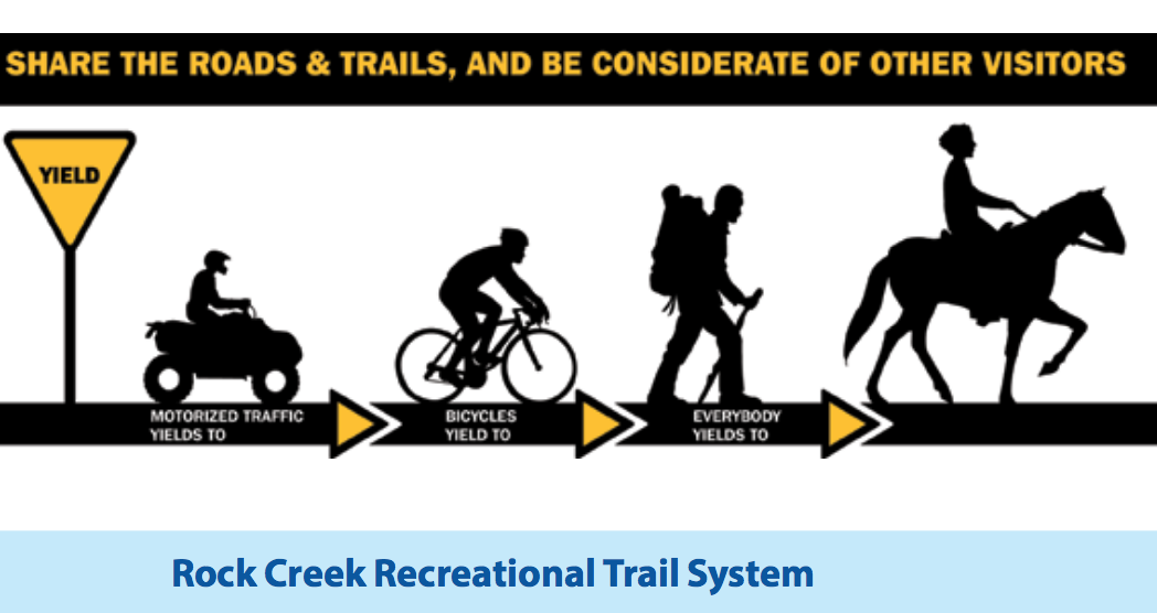
Rock Creek Recreational Trail System Rock Creek includes 110 miles of trails of all difficulty levels open from spring through fall. During winter, selected trails may be open depending on weather.

At 3,000 feet in elevation a portion of this trail system remains accessible in the winter. This system mixes motorcycles, equestrian, and biking use types so use caution.
​Access--
♦ Mace Mill Staging Area - From Georgetown drive 6 miles east on Wentworth Springs road. Turn right at the east entrance of the Balderston road (which makes a loop onto the Wentworth Spring road). Drive south for approximately one mile and turn left onto the Mace Mill road. Proceed approximately one and a half miles to the Mace Mill Staging Area.

​♦ Bald Mountain Staging Area - From Georgetown drive 10.5 miles east on Wentworth Springs road. Turn right onto the Rock Creek North road (12N72 road). Drive south for approximately one half mile and turn right onto the Bald Mountain Lookout road (12N71). The road leading to the Bald Mountain Staging Area will be on the right almost immediately after.


Your Voice is needed to Support the Hidden Falls Trail Expansion Project - one final meeting!

2/26/2021

 
Picture
FROM THE PLACER LAND TRUST:
"We need your comments to help convince the Placer County Board of Supervisors to approve approximately 30 miles of new trails and improved trail access and parking for Hidden Falls. The Placer County board of Supervisors will soon be voting on the Hidden Falls Trail Expansion Project and your voice needs to be heard to make it happen. Without your voice, it may not happen.

Approval of the plan for the trails is vital to families, hikers, runners, equestrians, and bikers and will improve the health of trail users, reduce parking issues, and reduce impact on the most used trails. Expanding the Hidden Falls trail network will be a priceless asset to Placer County, preserving the rural landscape for our children, and our children’s children for generations to come.
​
This is a rare opportunity for all of us, please take a few minutes to comment. The comments can be as simple as voicing your support and adding why it is important to you, your family, and your community. Let's make this happen!

The expansion project will need a large showing of support from the community as there is a very vocal, small minority trying to squash the expansion. 7 million dollars of our Placer County taxpayer dollars have been spent on the park, and 80,000 to 100,000 people use it yearly. There is a 3 million dollar grant to pay for the expansion. The opposition wants to keep the area to themselves and are not compromising, they want only docent-led access to the expansion (~100 people a year) which is the current status. We (ALL of us) paid for this park, the expansion has been in public planning for 15 years, compromises to the opposition have been made. It's time to provide to the people of Placer County, what has been built and paid for.

Email Your Voice here.

To see the original article at Placer Land Trust page, CLICK HERE.

Be Heard in Person
Speak at the Board of Supervisors Special Session
Yep! The Hidden Falls Expansion gets a special session.
3 PM Monday March 8th at the
Community Development Resource Center (CDRC)
3091 County Center Drive
Auburn, CA
or you can call in or Zoom, info here.
The supervisors want to hear from their constituents. Be heard!

Progress and What is Happening
​
The proposal has passed the Placer County Planning Commission with compromises to the neighborhood residents who oppose any expansion. The plan compromised to the residents on every one of their issues, but the local residents are not compromising in return and are just saying no. As taxpayers, all of us have paid into the 12-15 million dollars to make this project happen, we have also paid for the roads and services in the area. Hidden Falls is for all residents and not just to be a backyard for local residents. That is why we need your voice, as they are contacting their supervisor, telling them their singular view.
​
The projected scope of the plan has been reduced to better fit local concerns and economics. Parking lots have been reduced in the project but 30 miles of new trails are still in! Let's voice our support for more trails!
​
The Placer Parks Commission has approved the plan in an 8-0 vote.

The recent Town Hall discussions by County panelists confirmed three facts of particular importance:
  • Fire officials explained their satisfaction with the fire safety plans for both the full project and the reduced project
  • Traffic engineers explained how the project met acceptable standards for roads and traffic
  • County staff indicated that the traffic that would have been generated by build out of current zoning of the expansion area, if it had not been preserved, would be greater than traffic generated by the Trail Expansion project.
Hidden Falls has been a Huge Success! With Your Help, it will be even Better!
​​

Two trees blocking Pioneer Express Trail at Mile Marker 40

2/20/2021

 
Picture
Two trees blocking the Pioneer Express trail in two separate locations, but near Mile Marker 40 (approximately two miles south of Sterling Pointe Equestrian Staging). One is new, the other has been cut but still not safe to cross with horses.

Humbug Creek Trail re-opens in Malakoff Diggins SHP

2/12/2021

 
Picture
In mid-March 2020, just after the state’s general shut down in response to the COVID-19 pandemic, Nevada County experienced a significant winter storm event. Heavy snow and intense precipitation were welcomed, but the combination broke innumerable branches and whole trees, caused power outages, closed roads, and created landslides large and small along roads and trails throughout the county.
The Humbug Creek trail, which leads three miles down to the South Yuba River from Malakoff Diggins State Historic Park, was particularly impacted. Whole trees were jack-strawed across the trail, footbridges and walkways were undermined, and the trail bed was buried with soil and rock debris.
Faced with almost overwhelming challenges related to staffing shortages, COVID restrictions and protocols, and the extreme remoteness and rugged terrain of the Humbug Creek canyon, the State Park trail crew nevertheless mobilized to clear the downed trees, uncover the trail bed, secure the wooden structures and re-open the trail.
According to Julie Clark, the park’s maintenance supervisor, “This is by far the hardest trail in the Sierra Gold sector to work on, because it’s so long, so steep and so inaccessible.”
All materials had to be carried miles by hand, with the stalwart crew “acting as pack mules for weeks on end,” transporting almost two tons of redi-mix concrete in 90-pound sacks. The natural resource and forestry crew headquartered at the Tahoe District office spent two weeks just clearing the downed trees and re-routing sections of trail where the trail was undermined, or buried.
The sector maintenance crew performed yeoman’s work, hauling construction material, timber, tools, and equipment to perform the necessary work. All told, it took two full months of construction time, once the resource crew cleared the trail of the fallen trees.
Once the trail was assessed for damage, it was clear that some major effort would be needed to secure a trail bridge near the Humbug Creek waterfall. The up-canyon abutment was gone, and so the crew trudged up and down the trail, hauling the redi-mix on their backs, and hand mixing and excavating the footing to create a more secure support for the structure.
In a year when budgets have been stretched thin, staff re-assigned for contact tracing, and emergency and maintenance personnel challenged with record numbers of visitation and intense use, the Sierra Gold sector was able to accomplish an extremely difficult project with in-house expertise and dedicated crew members.
Chief Ranger Matt Green notes, “The project was completed in a time of COVID requiring extra time and expenses, which made it far more challenging. This is really symbolic of the extraordinary efforts by staff to keep public lands accessible during the most challenging times we’ve ever experienced. We were dealing with constant changes in state COVID protocols, parking lot closures, closing and then opening facilities, COVID physical impacts on staff and an ever-changing operational environment that increased stress and anxiety for us all.”
Humbug Creek Trail is just one of many trails that provides beauty and respite for people hungering for safe and healthy outlets during the pandemic. As more people find comfort in nature, the cumulative impacts of visitation and use could harm the resources, contributing to erosion, litter, and crowding.
Sierra Gold Parks Foundation encourages park users to take pride in their parks and the natural and cultural resources protected there. We encourage responsible use, and challenge our neighbors and friends to discover the calm and wonder that can result from a visit to one of our three local state parks – Malakoff Diggins State Historic Park, South Yuba River State Park, or Empire Mine State Historic Park.
These parks are open all year round, and offer a real treat any time of the year. 

 - Syd Brown is with the Sierra Gold Parks Foundation.
More info at http://www.sierragoldparksfoundation.org


CLICK HERE to see the original article and photos in The Union newspaper.

Picture

Downed tree makes trail from the Overlook not passable, ASRA has been notified

2/9/2021

 
Picture
Photo is taken on the trail on the way up to Robie Drive from the Overlook, just after the branch from the Rio Camino spur trail. Trail not passable by horses, hikers can crawl through. This has been reported to ASRA and should be cleared within a few days.
Picture


    Archives

    January 2023
    December 2022
    November 2022
    October 2022
    September 2022
    August 2022
    July 2022
    June 2022
    May 2022
    April 2022
    March 2022
    February 2022
    January 2022
    December 2021
    November 2021
    October 2021
    September 2021
    August 2021
    July 2021
    June 2021
    May 2021
    April 2021
    March 2021
    February 2021
    January 2021
    December 2020
    November 2020
    October 2020
    September 2020
    August 2020
    July 2020
    June 2020
    May 2020
    April 2020
    March 2020
    February 2020
    January 2020
    December 2019
    November 2019
    October 2019
    September 2019
    August 2019
    July 2019
    June 2019
    May 2019
    April 2019
    March 2019
    February 2019
    January 2019
    December 2018
    November 2018
    October 2018
    September 2018
    August 2018
    July 2018
    June 2018
    May 2018
    April 2018
    March 2018
    February 2018
    January 2018
    December 2017
    November 2017
    October 2017
    September 2017
    August 2017
    July 2017
    June 2017
    May 2017
    April 2017
    March 2017
    February 2017
    January 2017
    December 2016
    November 2016
    October 2016
    September 2016
    August 2016
    July 2016
    June 2016
    May 2016
    April 2016
    March 2016
    February 2016
    January 2016
    December 2015
    November 2015
    October 2015
    September 2015
    August 2015
    July 2015

    Categories

    All

    RSS Feed

Home
Contact
 Mother Lode Trails is YOUR local volunteer-run trail information and resource website. Here you can find
up-to-the minute information on trail alerts, links and trail news for Placer,  Yuba, and Nevada counties.
Mother Lode Trails is trademarked.