MOTHER LODE TRAILS
  • Home
  • About
  • Contact
  • Volunteer
  • Links
    • Law Enforcement Emergency
    • Federal, State, County Districts Parks & Trails
    • Running Clubs
    • Equestrian Clubs
    • Mt. Bike Clubs
    • Hiking Clubs
    • Trail Advocacy Organizations
    • Phone Numbers State & Federal Parks, Trails & Lands
    • Lost & Found on the Trails
    • Where to Eat on the Trails
  • News
  • Alerts

Mary West: Exploring Robie Point Fire Break Trail

12/24/2021

 
Picture
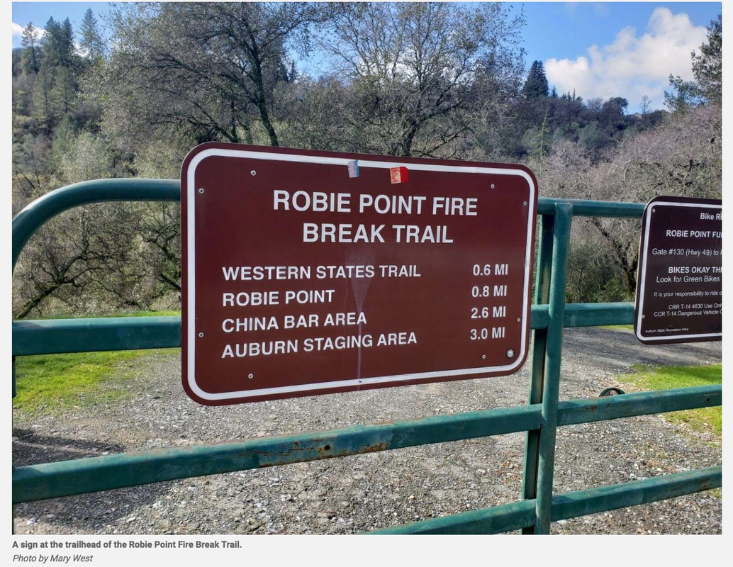
If you’ve ever started down into the canyon on Highway 49 toward the confluence and noticed all the cars at gate #130 (Murphy’s Gate — Robie Point Fire Break Trail) and wondered what’s down there, keep reading. You owe it to yourself to make the four-mile hike down to Canyon Creek from this direction. Its falls are popularly known as the Black Hole of Calcutta. Winter is the best time as the waterfall is running high and fewer visitors are impacting the trail.

Robie Point Fire Break Trail will take you to several trail options as is common in the Auburn State Recreation Area. On my last visit between storms we hiked down to where the trail meets the historic Western States Trail. We then took a left to Canyon Creek. You can also connect to Robie Point, China Bar and the Auburn Staging Area. These trails connect to still more hiking options.
The views of the American River weaving through the canyon is one of the delights of this trail. The waterfalls are another. This trail is home for me, so the rocks, trees and each bend in the trail holds memories of previous treks on the same path.

The history of the Western States Trail is a fun thought while making my way. Imagine the many equestrians and runners from around the world, and our local friends, who have raced on this trail over the many years of the Tevis Cup and the Western States 100-mile Endurance Run.
​

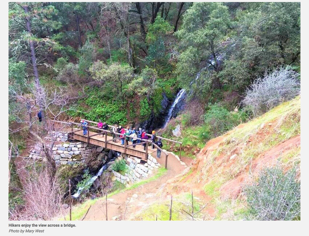
The bridge is our halfway point at about two miles from the gate. Now we make the climb back up. The wide flat trail is part of our mining history too. If you look for them, you can find the concrete foundations of train trestles that used to run along the river carrying lime from the quarry up to the road to be hauled away.

Just uphill from the intersection of the Western States Trail, look for a narrow trail to the left. Just a few yards back is a lovely cascading waterfall and another steep trail option. I keep saying maybe next time but have yet to take it. I retrace my steps back to the main trail to enjoy the canyon and river views back to the parking lot at gate #130.

Mary West is author of the book series Day Hiker – Gold Country Trail Guide I, II and III (2nd edition Available on Amazon). The books are a collection of the Day Hiker columns where West shares her longtime love of the outdoors, favorite hikes in Northern California’s Gold Country and beyond. West was the recipient of the 2017 and 2019 CRAFT Award for Best Outdoor Column and the 2020 Craft Award for her second book in the series-Day Hiker Gold Country Trail Guide by the Outdoor Writers of California. You can follow West on Facebook and Instagram

To see the complete article in The Union newspaper, CLICK HERE.

Picture

Auburn SRA to participate in State Parks First Day Hikes 2022

12/20/2021

 
Picture
What a better way kick start the new year than by getting some fresh air and enjoying the outdoors with the Annual First Day Hikes! California State Parks will participate at parks across the state in this national-led effort that encourages individuals and families to experience the beautiful natural and cultural resources found in the outdoors with a seasoned guide so that they may be inspired to take advantage of these treasures throughout the year.

Dedicated docents, volunteers and staff will show visitors the wonders of California’s state parks. Distance and rigor will vary per hike/activity, so visitors are encouraged to check out details of start times and description of hikes. 

Whether you are an experienced outdoor enthusiast or a new one, we look forward to seeing you in California’s park trails, beaches, mountains and the deserts but ask that you recreate responsibly. Visit the latest COVID-19 guidelines and additional safety tips for more information. 

Auburn State Recreation Area - two hikes
Where: Quarry Trail (Cool, CA – El Dorado County)
                             or
              Auburn Dam Construction Site

Times: Both hikes begin at 9 a.m. on January 1, 2022
Parking:
  • For Quarry Trail Hike park at the Quarry Trail Parking Area. $10 Day-Use fee per vehicle. (or parallel park in designated spaces along Hwy. 49 in El Dorado County)
  • For the Auburn Dam Construction site park at the Oregon Hill Parking Lot. $10 Day-Use fee per vehicle. (Auburn, CA – Placer County)
What to Expect:
  • Quarry Trail Hike: This moderate hike exercises your navigation skills while exploring flora, fauna, geology, and mountain quarries history. Dogs on leash are welcome. The hike route has one short technical section. The hike is 3.5-miles and lasts between 2.5 to 3 hours.
  • Auburn Dam Construction Site: This easy, out-and-back hike takes attendees to the Auburn Dam construction site, high above the North Fork American River. Although dam construction was halted in the early 1980s, the Auburn Dam remains a congressionally authorized project. Attendees will learn about the history of the Auburn Dam project and the forces that have hindered its construction. Pets are not allowed on this hike. The hike is 2 to 3 miles and lasts between 2 to 3 hours.
Ages: All ages are welcome. Children must be accompanied by a parent or guardian.
Preparation: Dress in layers and wear good hiking boots/shoes. Bring water and snacks.
Special instructions: Heavy rain will cancel. Bring a park map and compass if you have one.
Contact: For the Quarry Trail, email joseph.shanahan@parks.ca.gov; For the Auburn Dam Construction Site hike, email Erik.Taylor@parks.ca.gov.

If you would like to see all the First Day Hikes, CLICK HERE on the California State Parks website.

Break-ins at Sterling Pointe Equestrian Staging

12/11/2021

 
Picture
For the third time in the past month, a horse trailer was broken in to at Sterling Pointe yesterday, Oct. 10, 2021. This time it looks as if the thieves were scared off in the middle of their heist and didn't get anything. The Placer County Sheriff was called.

There are cameras at this trailhead and the culprits hopefully will be recognized and caught. This type of crime is usually caused by one person or one group who will repeatedly hit a place until they are caught.

Until they are, be aware at Sterling Pointe Staging:
1. Keep nothing of value in your truck or trailer.
2. Park your rig in clear sight of the homes and their cameras there.
3. Permanently mark your tack so it can be identified.
4. Photograph valuable items and keep them current.
5. Keep proof of ownership organized and available.
6. Of course, LOCK your trailer and truck.

If anyone looks suspicious, secretly and safely take photos of them, their vehicle and license plate. Call the Sheriff and alert them. If you feel uncomfortable or unsafe, leave the area.


(Photo credit USA Today)

French Meadows Forest Restoration Project Interactive Website

12/10/2021

 
Picture
French Meadows Partnership
To avoid the fate of another King Fire, a partnership was formed to collaboratively restore forest health and build resilience to future wildfires in the upper headwaters of the Middle Fork American River, around the French Meadows Reservoir.
You can access this map on the webpage <- CLICK HERE.
 Explore the map by clicking, dragging, and zooming to explore the region around French Meadows

The King FireThe catalyst of the French Meadows Forest Restoration Project was the 2014 King Fire, which burned over 97,000 acres in the American River watershed, much of it at high severity.

The fire impaired forest health, wildlife habitat, water quality, and hydroelectric assets by sending more than 300,000 tons of soil into the Rubicon River, a tributary of the Middle Fork American River.
These images of damage caused by the King Fire include a landslide area on the Rubicon River and the confluence of the Rubicon and Middle Fork American River. Notice the sediment in the water caused by the fire more than 30 miles upstream.

The French Meadows Forest Restoration Project, located just west of Lake Tahoe, covers more than 28,000 acres of public and private land in the Tahoe National Forest.

The partners who stepped up to collaborate together include the US Forest Service, Placer County, Placer County Water Agency, The Nature Conservancy, American River Conservancy, Sierra Nevada Conservancy, and Sierra Nevada Research Institute.

Together the partners developed a comprehensive restoration strategy for the headwaters of the Middle Fork of the American River that spans public lands managed by the Forest Service and private lands managed by the American River Conservancy.
​

Planning & ImplementationThe partners worked together to collaboratively plan the restoration effort across 28,000 acres that includes over 6,000 acres of ecologically-based thinning and 7,600 acres of prescribed fire on public land and another 1,600 acres of restoration on adjacent private land.
The French Meadows partnership embraces innovation and shared stewardship and together designed the restoration project to serve as a model for increasing the pace and scale of ecologically-based forest management and fuels reduction throughout the Sierra Nevada.

The planning and environmental compliance began in 2016 and took 18 months to complete. Implementation of the targeted ecological restoration work began in 2019; it will take five to seven years to complete the preliminary mechanical and hand-thinning to reduce fuels and prepare for reintroduction of fire as a restorative process...

To see the complete project, timelines, photos, maps, costs, benefits, visit the webpage:

https://storymaps.arcgis.com/stories/3cf1ddba68e34c59a5326e61e05d304b

Picture
Picture

Erick Walker new Forest Supervisor for Lake Tahoe Basin MU

12/4/2021

 
Picture
SOUTH LAKE TAHOE, Calif. — The second new U.S. Forest supervisor in a year will be taking charge of the Lake Tahoe Basin Management Unit.

On Thursday, the Forest Service announced that Erick Walker was named to the position and Vicki Lankford was named the new deputy forest supervisor for the Lake Tahoe Basin.

Walker arrived on Nov. 22 from the Okanogan-Wenatchee National Forest in Washington state, where he served as the deputy forest supervisor since May 2018.

He replaces former supervisor Bill Jackson, who decided to return to his home in Colorado after being named to the position Dec. 6, 2020.

“I would like to say I am very honored and excited to be returning to the Lake Tahoe Basin,” Walker said. “I look forward to working with the amazing staff on the unit and all of our partners to protect the health of Lake Tahoe and to serve the residents and visitors of this wonderful landscape.”

This marks a return for Walker to his Lake Tahoe roots with the Forest Service. 
He began working for the Tahoe Unit as a seasonal range technician in 1991, while earning his degree in natural resource management from the University of Nevada, Reno.

He left the Tahoe Basin in 1998 to continue his public service endeavors, which took him to the Almanor Ranger District of the Lassen National Forest. From there, Walker worked on the Humboldt-Toiyabe leading natural resource and public services programs. His interest in becoming a line officer landed him on the Green Mountain and Finger Lakes national forests where he served as the deputy Manchester district ranger. He also served as the Sandpoint district ranger for the Idaho Panhandle National Forests for nearly seven years.

Walker grew up in Monrovia, Calif., with the San Gabriel Mountains and the Angeles National Forest in his “backyard.
“Kate and I are excited about moving to Lake Tahoe and becoming community members,” Walker said of he and his wife. “We look forward to pursuing our interests in all things snow-related, hiking, biking, gardening, kayaking, and listening to live music.”

Lankford, arrived at Tahoe in September and comes from the Battle Mountain District of the Nevada Bureau of Land Management, where she served as a deputy district manager for five years.

Lankford began her federal career in California as a program technician with the USDA Tulare County Farm Service Agency in 1988. During her career she worked for the USDA’s office of Budget and Finance in Washington DC, and the USDA FSA Oregon State Office as a
“With the short time I’ve been in this position, I have already seen what an incredible team we have, their passion for serving the public, and protecting the natural resources,” said Lankford said. “I have also seen the powerful network of local partnerships in the region and look forward to reinforcing those relationships and working collaboratively towards shared successes.”

CLICK HERE to see original photos and article in Tahoe Daily Tribune


BLM Newsletter BYTES Trail Etiquette article updated because of increased trail use

12/4/2021

 
Picture
You nearly jump out of your skin as a mountain biker speeds past you.
A couple of minutes later, you practically trip over a dog as it bounds, off-leash, down the trail.
And before you know it, you get to second base with a scratchy patch of bushes in an effort to let other hikers continue down the narrow trail. We’ve all been there: irritated with the lack of common courtesy, and grumbling instead of enjoying time spent outside.

(Photo Credit: Walking in a single file on narrow trails protects local flora. Ben Maxwell / Pexels)
​

Since COVID started, more and more people have been seeking solace in the great outdoors, forcing long-time recreationists and newcomers to rub shoulders for the first time. Sometimes, these casual encounters can result in clashes filled with tension.

The solution is to practice proper trail etiquette. Following the unwritten rules of the trail can ensure proper civility, and allow adventurers new and old to enjoy their time in nature.

WHAT IS TRAIL ETIQUETTE
Trail etiquette is a series of guidelines that has the potential to make everyone’s experience in the outdoors more pleasant.

“It’s about being mindful. We’re all trying to enjoy this finite resource,” says Ben Lawhon of Leave No Trace, an organization that aims to help those heading outside to play make more responsible choices for themselves and the natural environments they’re in.

But while the social aspects of trail etiquette are paramount to creating a welcoming space, there can also be financial and ecological costs to not abiding by certain guidelines. For example, land management agencies around the country have seen excess trail usage in the past few years. And Lawhon, who works closely with these agencies, says they’ve reported excess damage to trails and plant life, a direct result of increased visitor traffic and people attempting to avoid one another.

Hikers and cross-country skiers can destroy delicate flora by deviating from designated paths, while mountain bikers can carve harmful ditches in the soft earth. Then, teams of employees or volunteers must spend valuable resources rebuilding trails and rehabilitating areas never intended to be trodden by human feet, tires, or skis.

Fortunately, a lot of the impact on trails is completely avoidable, Lawhon says. Proper trail etiquette is the first step.

DETERMINING WHO HAS THE RIGHT OF WAY
The most burning question trail etiquette can answer involves the right of way—who has it and who doesn’t.

TRAIL ETIQUETTE FOR HIKERS
On narrow trails, when you meet someone coming from the other direction or approaching from behind at a faster pace, one of you has to step aside and yield. Who does this depends on a few simple factors. If it’s another hiker and you’re on an incline, conventional wisdom says the person moving uphill has the right of way. If you’re the one headed downhill, then it’s up to you to step aside.

But Lawhon says that’s not a hard and fast rule. It’s always worth it to offer to step aside, but the other person may want a break if they’re in the middle of a long climb or are moving slowly. If they prefer to take a breather, they’ll let you know.

Who has the right of way when you’re on a flat stretch of trail is less straightforward. If there’s only space for one person or if someone is hiking behind you at a faster pace, find a flat patch of gravel or dirt nearby and take the opportunity to move over and let them pass. Whether you think you have the right of way or not, yielding to another hiker is always appreciated. If they yield for you, make sure to say thanks.

When trails are wide enough for multiple people to walk side by side, you should plan to hike single-file when other hikers are passing by. This will offer a little extra room so your boots or backpacks don’t collide.

TRAIL ETIQUETTE FOR OTHER TYPES OF TRANSPORT
Things often start to get hairy when people are using modes of transportation other than their feet. 
Yield means to slow or stop, which ever is needed to allow others to safely pass.

DIFFERENTLY ABLED
But there’s an easy golden rule you should always follow -- differently-abled recreationists always get the right of way, no matter if they’re on crutches, a handcycle, a power chair, or the like.

HORSES AND MULES
The second rank goes to pack animals like horses or mules, to which ***all other traffic should yield.*** Where you step off depends on the trail and the animals. The prevailing thought is that you shouldn’t stand uphill from a pack animal as they might not be able to see you and you could spook them as they get closer. But Lawhon recommends asking the lead rider where they recommend you stand. They know their animals best and what is least likely to provoke an unwanted reaction.

CYCLISTS
***Cyclists, on the other hand, should always yield***, so if you’re on two wheels, be prepared to use those brakes when passing hikers, horses, or just about anyone on the trail. In addition, it’s good trail etiquette to announce yourself when coming up behind or ahead of hikers so they aren’t surprised by your abrupt presence. Phrases like “Coming up behind” or “Passing on your left” are effective.

If another hiker is kind enough to step off the trail for you, you should also let them know how many cyclists are behind you so they don’t resume their hike prematurely. Also, make sure to thank them for their courtesy as you pass.

STEPPING OFF THE TRAIL
Every time you step off the trail, either because you have to or out of courtesy, beware of damaging plants and natural surroundings.

“Think about where your feet are going to go when you step off the trail and find a durable surface to pass on,” Lawhon advises.

Usually, dry grass, gravel, rocks, or dirt are best as they’re highly resilient to impact. A spot like that isn’t always readily available, though, so just do the best you can.

Finally, ***never blaze a new trail*** just to put some distance between you and others. Step aside, pause, and when those who have the right of way have passed, resume on the designated trail.

LEASHED DOGS ARE BEST DOGS
Dog owners must abide by trail etiquette, too, starting with adhering to all park regulations about leashing your pet. If off-leash dogs are permitted, you should still keep a leash handy for when you pass other hikers and pack animals. Keep in mind some people are afraid of dogs, and horses might get spooked at the sight of a pooch, so be considerate.
***Going off-leash can also be dangerous for your pet if there are venomous snakes or bears in the area.***

But if you have any doubts about whether or not your four-legged friend can go off-leash, it’s always better to play on the safe side. “Be a good advocate for dogs on trails,” Lawhon suggests. “The best way for you to support the dog-owner community is to put your dog on a leash.”

KEEP THE MUSIC DOWN AND EARBUDS
Blasting your favorite tunes on your portable Bluetooth speaker may be the perfect complement to a great hike, but you need to think about how this might impact others.

Everyone has their own reason to be outdoors–quiet solace or fun recreation–and it pays to be respectful of that. If you don’t feel safe in complete silence while in the backcountry, do what makes you feel comfortable, but consider turning down the volume or pushing pause when passing other hikers.

If you opt to use earbuds, ***make sure you leave one out*** so you can still be aware of your surroundings — there may be others around you who may be trying to pass or wildlife coming up behind you.

However you enjoy the outdoors, be considerate of those around you and the space where you’re recreating. If everyone agrees on how to behave, polite interactions on the trail are possible, and all involved can have a great time outside and protect the lands we love.


To see the complete article, CLICK HERE.

    Archives

    January 2023
    December 2022
    November 2022
    October 2022
    September 2022
    August 2022
    July 2022
    June 2022
    May 2022
    April 2022
    March 2022
    February 2022
    January 2022
    December 2021
    November 2021
    October 2021
    September 2021
    August 2021
    July 2021
    June 2021
    May 2021
    April 2021
    March 2021
    February 2021
    January 2021
    December 2020
    November 2020
    October 2020
    September 2020
    August 2020
    July 2020
    June 2020
    May 2020
    April 2020
    March 2020
    February 2020
    January 2020
    December 2019
    November 2019
    October 2019
    September 2019
    August 2019
    July 2019
    June 2019
    May 2019
    April 2019
    March 2019
    February 2019
    January 2019
    December 2018
    November 2018
    October 2018
    September 2018
    August 2018
    July 2018
    June 2018
    May 2018
    April 2018
    March 2018
    February 2018
    January 2018
    December 2017
    November 2017
    October 2017
    September 2017
    August 2017
    July 2017
    June 2017
    May 2017
    April 2017
    March 2017
    February 2017
    January 2017
    December 2016
    November 2016
    October 2016
    September 2016
    August 2016
    July 2016
    June 2016
    May 2016
    April 2016
    March 2016
    February 2016
    January 2016
    December 2015
    November 2015
    October 2015
    September 2015
    August 2015
    July 2015

    Categories

    All

    RSS Feed

Home
Contact
 Mother Lode Trails is YOUR local volunteer-run trail information and resource website. Here you can find
up-to-the minute information on trail alerts, links and trail news for Placer,  Yuba, and Nevada counties.
Mother Lode Trails is trademarked.