MOTHER LODE TRAILS
  • Home
  • About
  • Contact
  • Volunteer
  • Links
    • Law Enforcement Emergency
    • Federal, State, County Districts Parks & Trails
    • Running Clubs
    • Equestrian Clubs
    • Mt. Bike Clubs
    • Hiking Clubs
    • Trail Advocacy Organizations
    • Phone Numbers State & Federal Parks, Trails & Lands
    • Lost & Found on the Trails
    • Where to Eat on the Trails
  • News
  • Alerts

Truckee Donner Land Trust trails and access update

5/31/2022

 
Picture
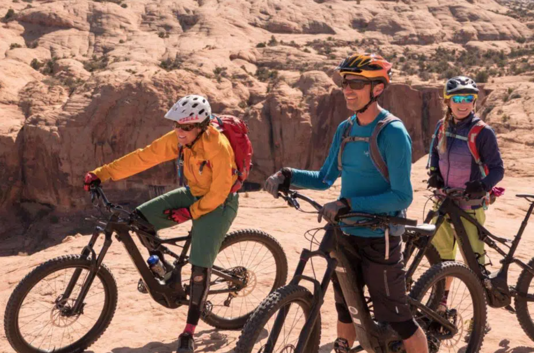
The Land Trust’s trail stewardship crew is hard at work getting the trails ready for the summer.
Our team generally works from low elevations to high, with Elizabethtown Meadows and Waddle Ranch ready to go (and great this time of year!) The Land Trust is working with our partners at Truckee Trails Foundation on new trails in Waddle Ranch starting June 1 – this shouldn’t impact existing trails, but please be aware of activity in the area.

The snow on Truckee Springs has melted, but be prepared for property closures as we work with our partners at the Town of Truckee on the next phase of the Truckee River Legacy Trail, and stay tuned for when that paved path is complete.

The dirt roads through Perazzo Meadows  are passable, save for a few muddy spots and down debris, and are improving each day. The gate at Webber Lake will be open soon, and the Lake is accessible for day use. Camping begins June 17. Until the parking opens, please be sure not to block access for vehicles getting the campground ready.

The road to Independence Lake is almost clear. Find out about our boating schedule and new requirements for a California Boater Safety Card here.

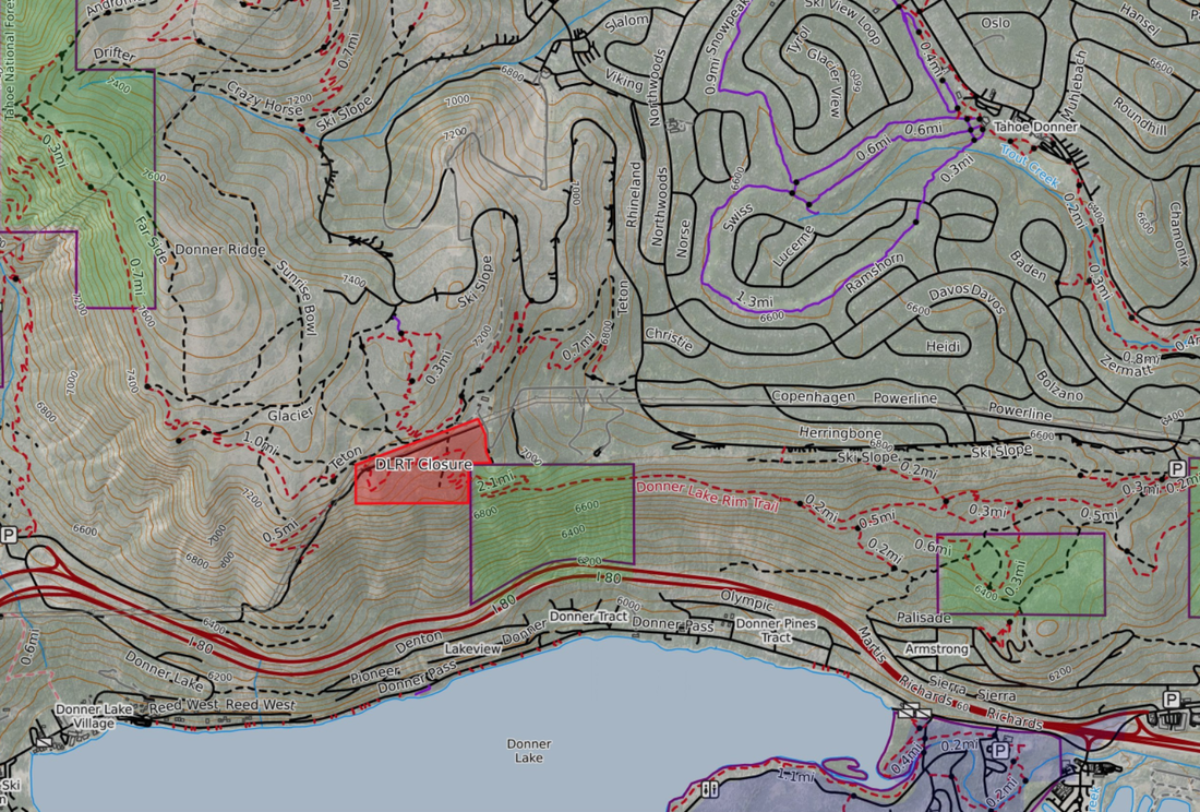
To the west, Donner Lake Rim Trail and Wendin Way are wonderful right now, with early season conditions and wildflowers beginning to emerge.  Please be advised: The western stretch of DLRT still has snow and downed trees, while Wendin Way and the eastern stretch of the Rim Trail are clear. There will be a trail closure for wildfire fuels management starting May 31, lasting three weeks. See map for details.

Donner Summit Canyon is clear to the Donner Lake vista point and picnic area, with some passable snowdrifts melting quickly. The creek is full and the flowers and wildlife are out!

Lower Carpenter Valley is nearly ready. The clearing of downed trees on the trail is underway and trail repairs from the past winter are next – we plan to have the trailhead open in the coming weeks.
Royal Gorge trails on Rowton Peak are still snow-covered. Point Mariah is generally passable with early season conditions including downed trees and debris.

Nevada County will work on Old Highway 40 between Donner Summit Canyon and the summit this summer. There will continue to be road closures Monday through Friday all season, preventing access to Black Wall on those days. Learn more here.

To see the original article in the Tahoe Donner Land Trust Newsletter May 2022, CLICK HERE.

Picture

Check out your free State Parks pass at your local library!

5/28/2022

 
Picture
What?
In partnership with Gov. Newsom's office and the California State Library, State Parks is providing free vehicle day-use entry to over 200 participating state park units operated by State Parks to library-card holders. (See list of our local area parks below). The California State Library Parks Pass is valid for entry of one passenger vehicle with capacity of nine people or less or one highway licensed motorcycle.

Who?
California public library-card holders can check out the State Library Parks Pass via their local public library. If you don’t have a library card, visit your local library to get one. The library card and park pass are free!

How?
Each library location will receive passes, including mobile libraries, for checkout by library patrons. Library patrons will be able to check out the pass for the allotted number of days allowed by the local library. Check with your library for guidelines and policies for returning your pass. Find your local public library at library.ca.gov/branches.

Where?
The pass entitles the user to a free vehicle day-use entry for one passenger vehicle with capacity of nine people or less or one highway licensed motorcycle at over 200 participating state park units. To view an interactive map with California’s public libraries and nearby participating state parks, click here.
https://castatelibrary.maps.arcgis.com/apps/instant/nearby/index.html?appid=07160e34a0da40e3ab5889228b6f44fe&sliderDistance=1

or here is the list of our local area parks:

LIST OF PARTICIPATING PARKS BY COUNTY

NEVADA
Donner Memorial SP (also in Placer)
Malakoff Diggins SHP
South Yuba River SP

PLACER
Auburn SRA (also in El Dorado)
Burton Creek SP
Donner Memorial SP (also in Nevada)
Folsom Lake SRA (also in El Dorado & Sacramento)
Kings Beach SRA
Tahoe SRA
Ward Creek Park Property
Burton Creek SP
Donner Memorial SP (also in Nevada)
Folsom Lake SRA (also in El Dorado & Sacramento)
Kings Beach SRA
Tahoe SRA
Ward Creek Park Property

EL DORADO
Auburn SRA (also in Placer)
D.L. Bliss SP
Ed Z’berg Sugar Pine Point SP
Emerald Bay SP
Folsom Lake SRA (also in Placer & Sacramento)
Marshall Gold Discovery SHP
Washoe Meadows SP

SACRAMENTO
Brannan Island SRA
Delta Meadows Park Property
Folsom Lake SRA (also in El Dorado & Placer)
Folsom Powerhouse SHP
Locke Boarding House Museum POI
Stone Lake Park Property

CLICK HERE to see more information about this free program for Californians.

Placer County Parks and Trails Master Plan approved by Supes

5/27/2022

 
Picture
POTENTIAL DOUBLING OF ACREAGE, TRIPLING OF TRAIL MILES
The Placer County Board of Supervisors on Tuesday approved the first-ever countywide Placer County Parks and Trails Master Plan, which could double the amount of recreation acreage by 2040 and triple the amount of trail miles.

The plan provides a 20-year-and-beyond vision for the development and operation of parks, recreation opportunities, open space and trail networks in the county. It also includes future improvements and maintenance for existing parks and trails.

With a final plan now in place, the county can adjust and update the plan to respond to changing trends and opportunities in a timely manner. It allows residents and decision makers to focus specifically on parks, trails and open space needs as part of the planning process and align those needs with current standards and funding and operational considerations.

“This plan gives us a road map into the future for parks and trails as our county population and the demand for these services continue to grow,” said Placer County’s new Parks and Open Space Director Steve Gayfield. “It also takes into consideration the diverse recreational values, which are important to our many distinct community areas.”

The plan includes a list of proposed capital improvement projects, each project having its own public review and approval process. It doesn’t approve any new parks and trails but directs staff on where to put resources into future development, priority projects and grant funding.

Tier 1 capital improvement projects, which are projects already in the planning or design stage, include Phase 1 of the Hidden Falls Regional Park Trails Expansion Project, Dry Creek Community Park in Roseville, the Resort Triangle shared-use path in the North Lake Tahoe region, Memorial Overland Emigrant Trail near Donner Summit and a new skate park in Colfax to name a few.

The plan also features projects that will complete trail connectivity throughout Placer County.
“Prior to this master plan, trail planning has been done on a localized basis within separate jurisdictions,” said Placer County Parks Administrator Andy Fisher. “An exciting thing about this plan is that it is the first time we looked at all the trails throughout Placer County and saw that there is a very real opportunity to fill in the gaps and create a connected regional network. Imagine one day being able to get on your bike in Roseville and pedal all the way to Lake Tahoe.”

“We have a wonderful opportunity for younger generations to experience the vast recreational and outdoor experiences that exist within our county,” said Placer County District 1 Supervisor Bonnie Gore. “I am very excited about the possibility of partnering with local programs for kids to learn about our open spaces, agricultural lands and trails.”

The final plan reflects community input provided over a two-year planning process through a series of public workshops, 2,400 completed online surveys, 60 focus groups and over 50 municipal advisory council meetings.

“From pickleball courts to dog parks to trail systems, the Parks and Trails Master Plan is a true reflection of the interests of our community members,” said Fisher. “This plan would not be possible without everyone’s valued participation.”

Feedback indicated high support for paved and dirt trails, natural areas and new and improved facilities particular to each community. The results also affirmed that the park and trail projects already in development in the county are consistent with communities’ desired improvements.

Learn more about the Placer County Parks and Trails Master Plan
online at http://www.placerparksplan.com
 
CLICK HERE TO see the original article in Roseville Today newspaper

JUNE 4 is NATIONAL TRAILS DAY!

5/27/2022

 
Picture
Find an event near you!
2022 National Trails Day Events
CLICK HERE TO FIND EVENTS NEAR YOU!

https://americanhiking.org/national-trails-day/find-an-event/#find-an-event-tables/
You can use the "Add filters" button above the table to filter events by activity, state, zip code, etc.

DON'T FORGET OUR OWN CELEBRATION OF TRAILS! Many events organized and in collaboration with Bear Yuba Land Trust.
CLICK HERE TO SEE THE BYLT EVENTS!
https://www.bylt.org/events/event/celebration-of-trails-2/


CA State Parks Free Admission for Veterans, Active and Reserve Military Members – Memorial Day, Monday, May 30

5/27/2022

 
Picture
Participating State Park Units for Free Admission for Veterans, Active and Reserve Military Members – Memorial Day, Monday, May 30, 2022 
*Veterans, active duty and reserve military personnel must show a valid military ID, or proof of discharge other than dishonorable or bad conduct, in order to receive the free admission. 

The ones below in GREEN are in our area:
  1. Anderson Marsh State Historic Park (SHP)
  2. Andrew Molera State Park (SP)
  3. Angel Island SP
  4. Annadel SP
  5. Año Nuevo SP
  6. Antelope Valley CA Poppy Reserve State Natural Reserve (SNR)
  7. Anza-Borrego Desert SP
  8. Auburn State Recreation Area (SRA)
  9. Benbow Lake State SRA
  10. Benicia SRA
  11. Bidwell-Sacramento River SP
  12. Bolsa Chica State Beach (SB)
  13. Bothe-Napa Valley SP
  14. Bethany Reservoir
  15. Calaveras Big Trees SP
  16. California Citrus SHP
  17. California State Railroad Museum
  18. Cardiff SB
  19. Carlsbad SB
  20. Carnegie State Vehicular Recreation Area (SVRA)
  21. Carpinteria SB
  22. Castle Crags SP
  23. Castle Rock SP
  24. Caswell Memorial SP
  25. China Camp SP
  26. Chino Hills SP
  27. Clay Pit SVRA
  28. Clear Lake SP
  29. Colonel Allensworth SHP
  30. Colusa-Sacramento River SRA
  31. Crystal Cove SP
  32. Cuyamaca Rancho SP
  33. Doheny SB
  34. Donner Memorial SP
  35. Eastern Kern County Onyx Ranch SVRA
  36. Ed Z’Berg Sugar Pine Point SP
  37. El Capitan SB
  38. Emerald Bay SP
  39. Emma Wood SB
  40. Folsom Lake SRA
  41. Folsom Powerhouse SHP
  42. Fort Ross SHP
  43. Fort Tejon SHP
  44. Fremont Peak SP
  45. Gaviota SP
  46. George J. Hatfield SRA
  47. Grover Hot Springs SP
  48. Half Moon Bay SB
  49. Hendy Woods SP
  50. Henry Cowell Redwoods SP
  51. Henry W. Coe SP
  52. Hollister Hills SVRA
  53. Humboldt Redwoods SP
  54. Hungry Valley SVRA
  55. Huntington SB
  56. Indian Grinding Rock SHP
  57. Jack London SHP
  58. Jedediah Smith Redwoods SP
  59. Kenneth Hahn (Baldwin Hills Scenic Overlook only)
  60. Kings Beach SRA
  61. La Purisima Mission SHP
  62. Lake Oroville SRA
  63. Lake Perris SRA
  64. Leo Carrillo SP
  65. Los Angeles SHP
  66. Malakoff Diggins SHP
  67. Malibu Creek SP
  68. Malibu Lagoon SB
  69. Manresa SB
  70. Marshall Gold Discovery SHP
  71. McArthur-Burney Falls Memorial SP
  72. McConnell SRA
  73. McGrath SB
  74. Millerton Lake SRA
  75. Mono Lake Tufa SNR
  76. Morro Bay SP
  77. Mount Diablo SP
  78. Mount San Jacinto SP
  79. Mount Tamalpais SP
  80. Natural Bridges SB
  81. New Brighton SB
  82. Oceano Dunes SVRA
  83. Olompali SHP
  84. Pacheco SP
  85. Palomar Mountain SP
  86. Sue-meg SP
  87. Pescadero SB
  88. Pfeiffer Big Sur SP
  89. Picacho SRA
  90. Pismo SB
  91. Point Lobos SNR
  92. Point Mugu SP
  93. Pomponio SB
  94. Portola Redwoods SP
  95. Prairie City SVRA
  96. Prairie Creek Redwoods SP
  97. Providence Mountains SRA
  98. Railtown 1897 State Historic Park
  99. Red Rock Canyon SP
  100. Refugio SB
  101. Richardson Grove SP
  102. Robert H. Meyer Memorial SB
  103. Russian Gulch SP
  104. Saddleback Butte SP
  105. Salt Point SP
  106. Salton Sea SRA
  107. Samuel P. Taylor SP
  108. San Buenaventura SB
  109. San Clemente SB
  110. San Elijo SB
  111. San Gregorio SB
  112. San Luis Reservoir SRA
  113. San Onofre SB
  114. Seacliff SB
  115. Silver Strand SB
  116. Silverwood Lake SRA
  117. Sinkyone Wilderness SP
  118. South Carlsbad SB
  119. South Yuba River SP
  120. Standish Hickey SRA
  121. Sugarloaf Ridge SP
  122. Sunset SB
  123. The Forest of Nisene Marks SP
  124. Tomales Bay SP
  125. Topanga SP
  126. Torrey Pines SB
  127. Torrey Pines SNR
  128. Tule Elk SNR
  129. Turlock Lake SRA
  130. Van Damme SP
  131. Wilder Ranch SP
  132. Will Rogers SHP
  133. William B. Ide Adobe SHP


https://www.parks.ca.gov/?page_id=30600&utm_medium=email&utm_source=govdelivery

Court Ruling calls for Impact Study on e-bike rules because National Parks Park Service acted in an "arbitrary and capricious manner..."

5/27/2022

 
Picture
From National Parks Traveler
May 24, 2022

 - By Kurt Repanshek
While the National Park Service failed three years ago to carefully study the potential impact of e-Bike use in the National Park System, a federal judge did not block their use but simply directed the agency to take "a hard look" at positive and negative impacts.

U.S. District Judge Rudolph Contreras's ruling was a qualified victory for Public Employees For Environmental Responsibility, which had sought to have the decision that allowed e-Bikes to travel on trails and roads used by muscle-powered bikes tossed out.

In his 54-page ruling handed down Tuesday, the judge held that the Park Service acted in an arbitrary and capricious manner in 2019 when P. Daniel Smith, the acting director of the Park Service, issued a directive ordering parks to treat e-Bikes "used for transportation and recreation in a similar manner to traditional bicycles" without requiring either an environmental assessment or more strenuous environmental impact statement examining any natural resource impacts from the decision.
"The Smith Directive attempted to avoid conducting any environmental analysis because the park units would do so, and the park units in turn largely declined to conduct additional analysis because the Smith Directive had already suggested that the change was minimal," Judge Contreras wrote.

While the Park Service would later implement a Final Rule formalizing the Smith Directive with some changes, the judge said that the Final Rule, by failing to require either an EA or EIS, "commits the classic NEPA error of considering only the effects of what a policy actually, directly authorizes rather than the reasonably foreseeable impacts of a policy."

The Park Service, Judge Contreras added, "appears to have 'simply assumed there were [no impacts] because the Final Rule did not authorize any impacts.'”
Furthermore, he wrote, the National Environmental Policy Act "is not just a box that must be checked at some point in an agency process, it is a crucial information-forcing statute designed 'to provide for informed decision making and foster excellent action.'”

While the Park Service maintained in the court's consideration of the matter that the final e-Bike rule "does not establish a precedent for future action," the court strongly disagreed, finding that "the [Final] Rule established a framework that could and foreseeably would be relied on for future action. And regardless, even if the Rule did not set a past precedent for expanded e-bike use, the Smith Directive surely did."

At the end of the day, the judge said he could not toss out the Smith Directive, as it had already been superseded by the Final Rule on e-Bike use in the National Park System.

As for the Final Rule, Judge Contreras wrote that "the record already suggests that there will likely be both positive and negative impacts of e-Bikes. The agency is required to take a hard look at them, and that analysis could potentially alter the outcome of the Final Rule, but there is 'at least a serious possibility that [NPS] will be able to substantiate its decision on remand.' Nor does NPS’s error necessarily require that NPS prepare a full EIS as opposed to some other form of NEPA compliance. On remand, the agency will need to determine the proper level of NEPA compliance for the Final Rule, adequately document its reasoning, and provide opportunity for public input as appropriate."

“The fact that the National Park Service sought to avoid studying the impact on park resources and visitors before opening trails to e-Bikes speaks volumes about the agency’s environmental decision making,” said PEER Executive Director Tim Whitehouse in reacting to the court's ruling. “In essence, the Park Service chose to leap before it looked.”

Click here to see the complete article in the National Parks Traveler.

Empire Mine partially closed May 24 - May 27, 2022

5/24/2022

 
Picture
PENN GATE STAGING and HARD ROCK PARTIALLY CLOSED UNTIL END OF WEEK
According to the Park, they are staging heavy equipment at the Penn Gate parking area, closing it, and working on the Hard Rock trail. The Hard Rock trail is closed for about 1/4 mile as they work.

Sometimes they open the trail in late afternoon after they are done. And, the work may go into next week if they don't get all the fencing repaired.


Folsom Lake Road and Trails Management Plan DRAFT READY - comments due JUNE 22, 2022!

5/23/2022

 
Picture
The Draft Plan is Ready for Review 
The draft Folsom Lake State Recreation Area and Folsom Powerhouse State Historic Park Road and Trail Management Plan is available for review and can be located here, 

https://www.parks.ca.gov/?page_id=28192

This is your opportunity to provide comment on proposed recommendations developed through public and agency input.   Please review the plan and provide input using the interactive comment tool located here.  Comments can also be submitted by email to trails@parks.ca.gov 

YOU ONLY HAVE 30 DAYS!
​Comment submittal deadline is June 22, 2022. 


Online meeting Folsom Lake Road and Trails Management Plan meeting
Date and timeWed, June 8, 2022
6:00 PM – 8:00 PM PDT
LocationOnline event
​Attend to learn about the Folsom Lake State Recreation Area and Folsom Powerhouse State Historic Park Draft Road and Trail Management Plan.

The California Department of Parks and Recreation has prepared a Draft Road and Trail Management Plan (RTMP) for Folsom Lake State Recreation Area (SRA) and Folsom Powerhouse State Historic Park (SHP) and needs your input!

Please join the virtual public meeting on 
Wednesday, June 8, 2022 from 6:00 PM to 8:00 PM 
to learn more about the RTMP draft and share your thoughts.

​Comment submittal deadline is June 22, 2022. 

The purpose of the RTMP is to provide specific and detailed management direction for roads and trails, guiding the operation, maintenance, and development of the road and trail system. Public input is critical for ensuring that the RTMP best responds to the needs and preferences of existing and potential visitors. Opportunities to participate include joining the public meeting, registering to speak during the meeting's public comment period, and sharing input on the online public commenting tool. To learn more about
the planning process and opportunities to participate, visit: https://www.parks.ca.gov/FolsomSRA-RTMP


​Comment submittal deadline is June 22, 2022. 
​

This meeting will be conducted via Zoom and recorded. By attending the meeting, you are consenting to being photographed or video recorded. You will receive an initial email confirming your registration, and another email prior to the event with instructions for joining the meeting. Meeting participants are encouraged to join from a personal computer, tablet, or smart phone with an internet connection. Participants will also have the option to join by phone, but a phone connection may limit your ability to participate.

​Comment submittal deadline is June 22, 2022. 

Persons requiring special accommodations should contact trails@parks.ca.gov by June 5, 2022.

Hidden Falls close due to fire danger May 19, May 20

5/19/2022

 
Picture
Due to excessive heat and fire danger, the park will be closed Thursday, May 19, 2022, and Friday, May 20, 2022.
The determination to close Hidden Falls is made in conjunction with the issuance of fire-related warnings issued by the National Weather Service and in consultation with CalFIRE personnel. Please view the information below for more details.
 
HIDDEN FALLS REGIONAL PARK TO CLOSE ON DAYS OF EXTREME FIRE WEATHER
As part of our land stewardship and commitment to reducing wildfire risk, Hidden Falls Regional Park will be closed to public access during days that are determined to be extreme fire weather. Notice will be given as far in advance of closure days as possible but may be as short as 12 hours’ notice before closure the following day.  Please check the status on this webpage immediately before leaving on your visit to Hidden Falls this summer.  Visitors with reservations during closure days will be given credit for the purchase price of their reservation to be used for a future visit.  Thank you for your understanding in helping to keep Hidden Falls and its neighbors safe from wildfire.

WHERE CAN I CHECK THE CLOSURE STATUS BEFORE MY VISIT TO HIDDEN FALLS?
Notifications will be posted to the following website:
https://www.placer.ca.gov/6106/Hidden-Falls-Regional-Park or by calling (530) 886-4901. You may also check our social media sites for updates.

HOW WILL CLOSURE DAYS BE DETERMINED?
Staff will determine extreme fire weather days in consultation with weather and fire officials and would generally coincide with conditions that prompt Red Flag and Excessive Heat warnings.
Location
7587 Mears Place
Auburn, CA 95602
Reservations are required on all weekends.  In addition, the following days during 2022 will require a parking reservation:
2022 High Usage Dates: 1/1, 1/17, 2/21, 4/11 – 4/22, 5/30, 7/4, 9/5, 10/10, 11/11, 11/24 - 11/25, 12/19 - 12/31. 
HoursThe park is open from sunrise to sunset daily. Specific opening and closing times are posted daily by park rangers at the site. Please note closure information and exit the park before closing time.
​

Humbug History Day at Malakoff Diggins SHP - June 11

5/17/2022

 
Picture
Humbug History Day 
SATURDAY, JUNE 11, 2022 
(11am - 4pm) 
Malakoff Diggins State Historic Park  
Event hosted by the Sierra Gold Parks Foundation 
Malakoff Diggins State Historic Park. 
Public is invited!  

​After a 2-year hiatus due to the epidemic, Humbug History Day is returning to commemorate California’s golden olden days with volunteers in period costume interpreting the historic heritage at North Bloomfield (formerly Humbug) California, the State Park’s semi-ghost town.

The furnished historic buildings include a residence built in 1852, drug store, barbershop, general store, saloon, blacksmith, stable and the Park Museum/visitor center.

Special attractions include the world’s shortest parade, the Carmichael Jug Band, Chris Crockett and his guitar, square dancing demonstrations, story-telling by Chris Enss in the Museum, ECV Chapter 10 Clampers Barbecue, Lazy Dog ice cream treats, root beer floats, popcorn, historic crafts, face painting, and kid’s games, as well as the ceremonial demonstration of the “monitor” water cannon.

Malakoff Diggins State Historic Park
23579 North Bloomfield Road
Nevada City, CA 95959

Cost: $10/vehicle for parking; $9 for seniors.

*DIRECTIONS:
Follow Highway 49 North, 11 miles from Nevada City. Turn right on Tyler Foote Road and follow the double-yellow lines for 15 miles to the Park. (Note: Do not access the park via North Bloomfield Road from Nevada City, as the road is rough and unpaved after Edwards Crossing.

​FACEBOOK EVENT:
https://www.facebook.com/events/1036166680622287/
<<Previous

    Archives

    January 2023
    December 2022
    November 2022
    October 2022
    September 2022
    August 2022
    July 2022
    June 2022
    May 2022
    April 2022
    March 2022
    February 2022
    January 2022
    December 2021
    November 2021
    October 2021
    September 2021
    August 2021
    July 2021
    June 2021
    May 2021
    April 2021
    March 2021
    February 2021
    January 2021
    December 2020
    November 2020
    October 2020
    September 2020
    August 2020
    July 2020
    June 2020
    May 2020
    April 2020
    March 2020
    February 2020
    January 2020
    December 2019
    November 2019
    October 2019
    September 2019
    August 2019
    July 2019
    June 2019
    May 2019
    April 2019
    March 2019
    February 2019
    January 2019
    December 2018
    November 2018
    October 2018
    September 2018
    August 2018
    July 2018
    June 2018
    May 2018
    April 2018
    March 2018
    February 2018
    January 2018
    December 2017
    November 2017
    October 2017
    September 2017
    August 2017
    July 2017
    June 2017
    May 2017
    April 2017
    March 2017
    February 2017
    January 2017
    December 2016
    November 2016
    October 2016
    September 2016
    August 2016
    July 2016
    June 2016
    May 2016
    April 2016
    March 2016
    February 2016
    January 2016
    December 2015
    November 2015
    October 2015
    September 2015
    August 2015
    July 2015

    Categories

    All

    RSS Feed

Home
Contact
 Mother Lode Trails is YOUR local volunteer-run trail information and resource website. Here you can find
up-to-the minute information on trail alerts, links and trail news for Placer,  Yuba, and Nevada counties.
Mother Lode Trails is trademarked.