MOTHER LODE TRAILS
  • Home
  • About
  • Contact
  • Volunteer
  • Links
    • Law Enforcement Emergency
    • Federal, State, County Districts Parks & Trails
    • Running Clubs
    • Equestrian Clubs
    • Mt. Bike Clubs
    • Hiking Clubs
    • Trail Advocacy Organizations
    • Phone Numbers State & Federal Parks, Trails & Lands
    • Lost & Found on the Trails
    • Where to Eat on the Trails
  • News
  • Alerts

National Weather Service Red Flag warning for our area this weekend

9/25/2020

 
Picture
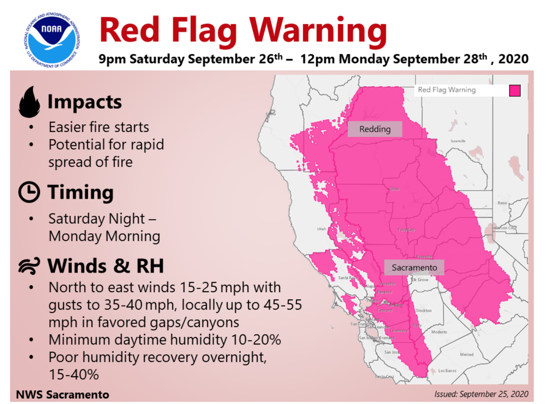
Starting 9:00 PM Saturday September 26 and ending noon Monday September 28, the following counties in the Mother Lode Trails coverage area is under Red Flag warning:
Nevada
Yuba
Sacramento
El Dorado
Placer


To see the complete weather report CLICK HERE.

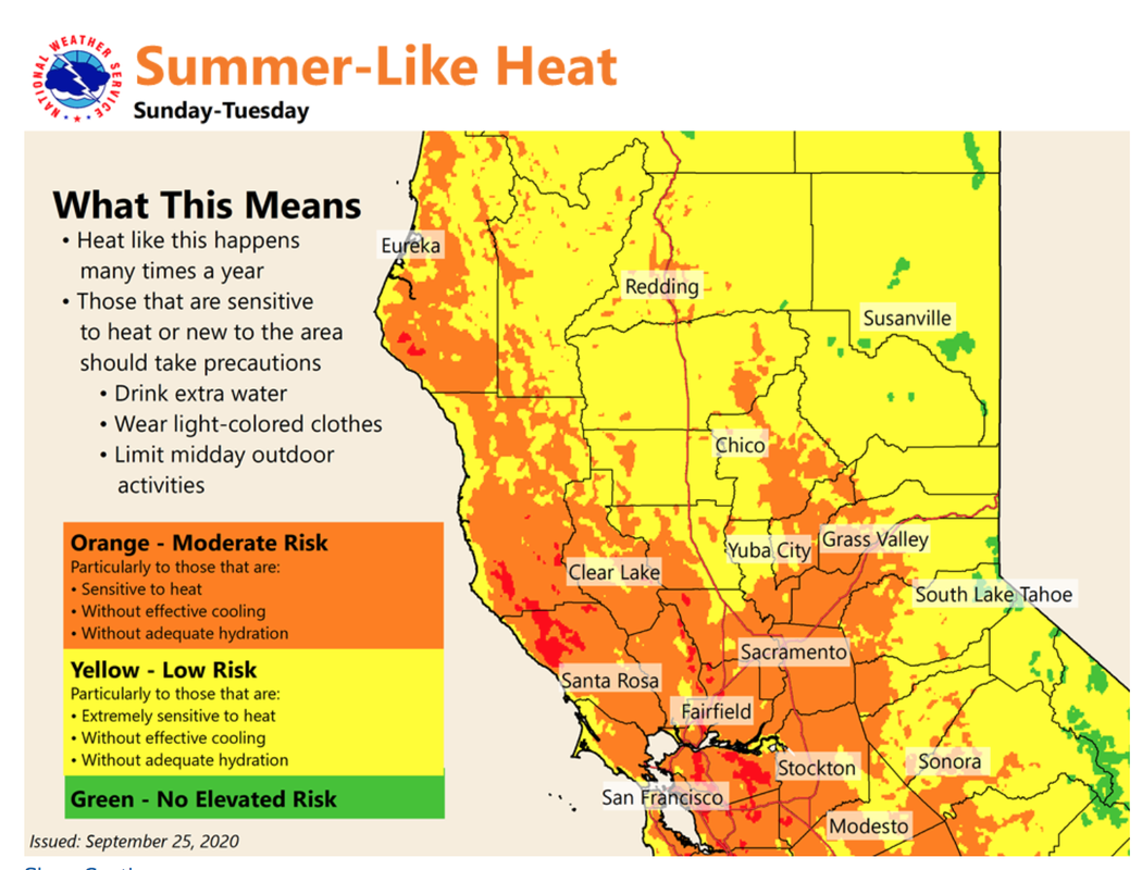
Expect gusty winds, high heat. Here is what you can do to stay safe.
​

Picture
This warning includes heat risk.
Picture

Hidden Falls closed Sept. 26 - 28 for high fire danger

9/24/2020

 
Picture
Hidden Falls Regional Park in North Auburn will be closed Sept. 26-28 due to extreme fire weather conditions.
Visitors with reservations during closure days will be given credit for the purchase price of their reservation.
​Learn more:
https://www.placer.ca.gov/6106/Hidden-Falls-Regional-Park

UPDATE 9/23/2020: Tahoe National Forest re-opening

9/23/2020

 
Picture
UPDATE 9/23/2020
Nevada City, Calif. — Along with the general reopening this past Saturday, a new Forest Closure Orders will strictly prohibit the following activities across the entire Tahoe National Forest through October 18, 2020:
  • Camping, except within Developed Campgrounds open for public use, within the Granite Chief Wilderness, and within 500 feet of the Pacific Crest Trail.
  • Discharging a firearm, except while engaged in a lawful hunt pursuant to state, and federal law and regulations. 
In addition, a standing Emergency Fire Restriction Order strictly prohibits the following activities across all National Forests in California through September 25, 2020:
  • Building, maintaining, attending or using a fire, campfire, or stove fire.
    • This includes all gas stoves of any kind
  • Smoking
The following campgrounds are open or will open 9/23.
Campgrounds opening 9/25 are noted.


  • Highway 89, South
    • Goose Meadow Campground
    • Granite Flat Campground
    • Silver Creek
  • Foresthill Divide Road
    • Giant Gap Campground
    • Shirttail Campground (Reopens 9/25)
  • ​Gold Lake Road
    • Packsaddle
    • Salmon Creek
    • Sardine
  • ​Marysville Road
    • Dark Day Campground
    • Schoolhouse Campground
  • ​Mosquito Ridge Road
    • French Meadows (Water systems limited, campers are asked to conserve water)(Reopens 9/25)
  • Interstate 80
    • Indian Springs
    • North Fork (Reopens 9/25)
  • ​Highway 49
    • Fiddle Creek
    • Rocky Rest
    • Carlton Flat
    • Indian Valley
    • Cal Ida
    • Union Flat
    • Wild Plum
  • Highway 20
    • White Cloud (some sites closed due to hazard trees)
    • Skillman
  • Highway 89, North 
    • Cold Creek
    • Cottonwood
    • East Meadow (operated by NID)
    • Lower Little Truckee
    • Meadow Lake – PG&E managed site, first-come first-serve only
    • Prosser Family (Water systems under repair, campers must pack in water
    • Pass Creek (operated by NID)
    • Upper Little Truckee
  • Bowman Lake Road
    • Carr-Feeley – PG&E managed site, first-come first-serve only
    • Lindsey – PG&E managed site, first-come first-serve only
    • Rucker Lake  – PG&E managed site, first-come first-serve only

To see the press release and further information CLICK HERE.

====================
PREVIOUS UPDATES:
As of 9/22 the following campgrounds will open:
Upper and Lower Little Truckee, East Meadow and Pass Creek.

Forest Service personnel will begin opening restrooms, gates, day-use sites, and Forest Service roads beginning at 8:00 a.m. Saturday, September 19, 2020. Most campgrounds will remain closed through the weekend.

A limited number of campgrounds opened 9/19, including:
  • Cottonwood
  • Giant Gap
  • Whitecloud

  • Cold creek
  • Schoolhouse
  • Granite Flat

  • Indian Valley
  • Prosser
  • Silver
Previous post:

Campfires, Dispersed Camping, and Target Shooting Still Prohibited

Nevada City, Calif. —The Tahoe National Forest is reopening this weekend after nearly two weeks of unprecedented, emergency closures due to California wildfires and wildfire risk. The forest remains closed until 8:00 a.m. Saturday, September 19, 2020.
Along with the general reopening this Saturday, a new Forest Closure Orders will strictly prohibit the following activities across the entire Tahoe National Forest through October 18, 2020:
  • Camping, except within Developed Campgrounds open for public use, within the Granite Chief Wilderness, and within 500 feet of the Pacific Crest Trail.
  • Discharging a firearm, except while engaged in a lawful hunt pursuant to state, and federal law and regulations. 
In addition, a standing Emergency Fire Restriction Order strictly prohibits the following activities across all National Forests in California through September 25, 2020:
  • Building, maintaining, attending or using a fire, campfire, or stove fire.
    • This includes all gas stoves of any kind
  • Smoking​
As of 9/22 the following campgrounds will open:
Upper and Lower Little Truckee, East Meadow and Pass Creek.

CLICK HERE for complete press release at Tahoe National Forest website

NO Thurs. Sept. 24 Hidden Falls Planning Commission meeting!

9/22/2020

 
The Placer County Planning Commission meeting for Thursday, September 24 will NOT include a hearing for Hidden Falls Expansion.
​
Today, Tuesday morning, September 22, the Placer County Board of Supervisors instructed Park Administrator Andy Fisher to reschedule the hearing for late October. The reason was to give everyone more time to study the "reduced" scope of Hidden Falls Expansion.

HIDDEN FALLS TRAIL ADVOCATES 
Stay tuned for the precise date in October.

The good news is that the Board of Supervisors voted 4-0 to allow Placer County Parks to submit a bid to state agencies for $3 million funding for Hidden Falls expansion.

Submitted by
Robert Hadley Sydnor

CA State Parks Foundation starts petition to lawmakers to save our parks - sign it now

9/22/2020

 
Picture
The California State Parks Foundation is very concerned about the survival of our State Parks as our economy is tanking and affecting the operating funds for every park in our state. Mother Lode Trails urges you to sign this petition. YOU can help save our Parks.
To access the petition CLICK HERE.
https://p2a.co/cqjrsyd

​
PETITION TEXT
"California’s state parks are vitally important to the health of our state’s environment, economy, and communities. With over 81 million visitors each year, our state parks have proven time and again that they are a necessary part of Californians lives.COVID-19 has intensified challenges facing our state parks, putting their future in jeopardy. California will soon face the deepest budget deficit in state history projected at a record $54.3 billion.

In these uncertain times, our state parks need your support.

As California lawmakers chart a path forward, join California State Parks Foundation in urging them to take into consideration the critical role parks play in the lives of Californians.

Our parks are the greatest public health, recreational, historic and natural resource we have. They are critical to a thriving California as an economic engine for revenue, a living classroom for kids, and a top biological hotspot in the world.

We must work together to keep parks whole, using our voice to demonstrate parks are necessary. We must ensure state parks are funded to protect jobs, preserve the land, boost visitor experiences, and increase access for those who don’t have opportunities to benefit from the great outdoors.
Let’s raise our voices together for parks. When we do, we preserve these incredible places for generations to come."

Mother Lode Trails urges you to sign this petition.

To access the petition CLICK HERE.
https://p2a.co/cqjrsyd

Hidden Falls expansion to boost amenities and trail network -NO Sept. 24 meeting!

9/21/2020

 
Picture
AUBURN, Calif. – The Placer County Planning Commission will NOT hold a public meeting on the Final Subsequent Environmental Impact Report for the county’s proposed Hidden Falls Regional Park Trails Expansion Project on Sept. 24 in North Auburn.

The SEIR details the proposed expansion of Hidden Falls’ natural-surface, multi-use trail network onto approximately 2,765 additional acres of land owned by either the Placer Land Trust or Placer County, or where the county owns easements.

Approximately 30 miles of trails (including existing and proposed trails) within the expansion areas would be added to the 30 miles of existing trails within the current park boundary.

AMENITIES
Two new parking areas and an additional overflow area within the existing Hidden Falls Park parking area are also proposed, as well as other amenities such as bridges, overlooks, picnic benches and tables, restrooms, drinking fountains and equestrian facilities.
REDUCED PROJECT
After a series of public meetings and further analysis of the original proposed project the Parks Division modified its proposal and is recommending to the Board of Supervisors a reduced project.
The reduced project includes: a limitation on the development of the Twilight Ride parking area to only 54 automobile parking spaces and 20 equestrian spaces, reduction of parking availability and use of the Garden Bar entrance, and use of the existing dirt parking area off Curtola Ranch Road for Harvego Preserve docent-led tours. The proposed spaces reflect an approximately 60 percent reduction in the number of spaces studied by the SEIR.

The reduced project would not increase the frequency of docent-led tours in the Harvego Preserve beyond what is currently allowed (12 per year), and would not include parking or trail access improvements off of Curtola Ranch Road.

PARKING
The project includes 25 additional overflow parking spaces within the existing Hidden Falls Park parking area off of Mears Drive in North Auburn.

PUBLIC MEETING WILL NOT BE HELD AS PLANNED
The Placer County Planning Commission meeting will NOT be held at 4 p.m. on Sept. 24. The meeting agenda and public participation details are available on the Planning Commission webpage, here.

https://www.placer.ca.gov/2537/Hidden-Falls-Regional-Park-Trail-Network

The purpose of the meeting WAS to provide responsible and trustee agencies, residents, civic organizations and other interested parties with an opportunity to provide comments on the Final SEIR and the proposed project.

The county will conduct a Board of Supervisors hearing this fall to decide upon the certification of the SEIR, as well as the proposed conditional use permit modification. The CUP modification will cover both the existing Hidden Falls Regional Park as well as the Trails Expansion area.

The SEIR is available online, and paper copies are also available for public review during normal business hours at the following locations:

Placer County Community Development Resource Agency
3091 County Center Drive, Suite 190, Auburn, CA 95603
Office hours: 9 a.m. – 2 p.m., Monday, Tuesday, Wednesday and Fridays
​

Placer County Clerk-Recorder’s Office
2954 Richardson Drive, Auburn, CA 95603
Office hours: 8 a.m. – 5 p.m., Monday – Friday

To see the original article in Roseville Today newspaper CLICK HERE.

​

UPDATE: Loafer Creek Horse Camp saved, 50% Lake Oroville SRA burned in the Bear Fire

9/19/2020

 
Picture
Sept. 19, 2020
Submitted by Bob Sydnor (AERC, GCTC member)
In regard to the fate of Loafer Creek Equestrian Campground within Lake Oroville State Recreation Area. We have been uncertain if the North Complex Fire in Butte County might have burned this horse campground.
The (tentative) good news as of September 18, is that Loafer Creek Horse Campground has been spared. About one-third of the northeastern section of Loafer Creek has apparently been burned, including parts of the public campground.
Pictured is the fire perimeter map as of 9/18/2020.  But this can rapidly change, so stay tuned.


CLICK HERE for my 7-page detailed report about Loafer Creek Horse Campground that was written two years ago.

Picture
OROVILLE, Calif. - The Bear Fire burned a significant portion of Lake Oroville's shoreline but damage along the lake was sparse. It will remain closed until evacuation orders along all parts of the lake are lifted.
Lake Oroville, in total, has a shoreline of about 168 miles. Over 50% of the recreation area along the lake, which is a large portion of the shorline, burned during the Bear Fire.
Most of what burned was vegetation but several of the Loafer Creek recreation area's facilities have sustained minor damage, including the campground.
Other areas are still being evaluated, as are hazard trees in many areas. Many of these are still needing to be cleared. 
Lake Oroville is still closed to the public at this time.
"The lake is under closure right now. The whole lake here is under that closure. We can not allow any boating at this time. There are portions of the lake, specifically the north fork, the south fork and the middle fork that are within those mandatory evacuation zones. The rest of the lake including the main body are in the warning zones, but because of the madatory evacuation orders in those other zones, we can not allow any access on the body of the lake," said Matt Teague, the Northern Buttes District Superintendent, California State Parks.
He says as soon as evacuation orders are lifted on all areas of the lake, then the lake will be able to open to the public.
One house boat also burned during the fire but the boat fire has not been attributed to the Bear Fire as of yet.
The marinas have had no reported damage.
With regards to all the ash that you might be seeing floating around, the California Department of Water Resources says they will be investigating this soon to see if it has affected the water quality. 

CLICK HERE to see video on Action News Now


Tahoe and Eldorado National Forests may partially reopen Saturday, Sept. 19, 2020

9/18/2020

 
Picture
Many California National Forests remain closed as some partially reopen
The USDA Forest Service Pacific Southwest Region announces increased access to some National Forests in California beginning at 8:00 a.m. on Saturday, September 19, 2020.

Nine National Forests may open to varying degrees. Visitors should contact the following National Forests for more information on their status: Eldorado NF, Lake Tahoe Basin Management Unit, Lassen NF, Mendocino NF, Modoc NF, Plumas NF, Shasta-Trinity NF, Stanislaus NF, and the Tahoe NF. These forests will implement their own forest orders that will either limit dispersed use or provide for area closures around fires.

The prohibition of the use of any ignition source on all National Forest System lands (campfires, gas stoves, etc.) throughout California remains in place.

Nine National Forests in California remain closed: Angeles NF, Cleveland NF, Los Padres NF, Inyo NF, Klamath NF, San Bernardino NF, Sequoia NF, Sierra NF, and Six Rivers NF. This decision will continue to be reviewed daily with evolving fire and weather conditions.
---------------------------------
​
Press release from 9/18/20
Forest Service to Increase Access to National Forests in California
VALLEJO, Calif. – The USDA Forest Service Pacific Southwest Region announces increased access to some National Forests in California beginning at 8:00 a.m. on Saturday, September 19, 2020.
The prohibition of the use of any ignition source on all National Forest System lands (campfires, gas stoves, etc.) throughout California remains in place.

Nine National Forests in California remain closed: Angeles NF, Cleveland NF, Los Padres NF, Inyo NF, Klamath NF, San Bernardino NF, Sequoia NF, Sierra NF, and Six Rivers NF. This decision will continue to be reviewed daily with evolving fire and weather conditions.

Nine other National Forests may open to varying degrees. Visitors should contact the following National Forests for more information on their status: Eldorado NF, Lake Tahoe Basin Management Unit, Lassen NF, Mendocino NF, Modoc NF, Plumas NF, Shasta-Trinity NF, Stanislaus NF, and the Tahoe NF. These forests will implement their own forest orders that will either limit dispersed use or provide for area closures around fires.

Conditions can change quickly. Therefore, we emphasize that all citizens heed local announcements for changes in conditions and potential evacuations.

“We understand how important access to the National Forests is to our visitors,” said Randy Moore, Regional Forester for the USDA Forest Service Pacific Southwest Region. “Continued closures are essential based on extreme fire conditions, critical limitations of firefighting resources, and to provide for firefighter and public safety.”

Again, visitors are encouraged to contact their local National Forest for more information. We have developed a web map to help visitors find out which sites are open. Visit our online map at https://www.fs.fed.us/r5/webmaps/RecreationSiteStatus/. For additional questions, please contact your local National Forest.
​
The Forest Service manages 18 National Forests in the Pacific Southwest Region, which encompasses over 20 million acres across California, and assists State and Private forest landowners in California, Hawaii and the U.S. Affiliated Pacific Islands. National forests supply 50 percent of the water in California and form the watershed of most major aqueducts and more than 2,400 reservoirs throughout the state. For more information, visit www.fs.usda.gov/R5

Placer CO Planning Commission votes 7-0 in favor of Hidden Falls expansion

9/18/2020

 
Picture
(Gold Country Trails Council representatives with their green bandanas. Photo Credit: Jeff Foltz)
The Placer County Parks Commission on a 7-0 vote recommend to the Placer County Board of Supervisors the reduced Hidden Falls expansion plan which includes the full 30 miles of new trails, new trail access off of Bell road with auto and equestrian parking spaces, but reduces overall auto parking and trailer parking for the entire project. 

All trail users were in attendance, but the equestrian groups especially had a great showing at the public hearing, including several representatives from Gold Country Trails Council, Meadow Vista Trails Association, American Endurance Ride Conference and Loomis Basin Horsemen. 

Next Thursday, Sept. 24, at 5:00 pm, is the Placer County Planning Commission meeting where they will consider a conditional use permit, approving the reduced Hidden Falls expansion project, and consider the environmental impact report. From there, forward their recommendation to the Placer County Board of Supervisors who will make a final decision at there late October early November meeting.

Hidden Falls final hearings starting Thursday, Sept. 17 - you are needed!

9/16/2020

 
Picture
It's time to step up to support the Hidden Falls Regional Park Expansion for trails and parking.
*** CALL TO ACTION ***
Mother Lode Trails supports the full EIR and the Reduced Project Plan for the Hidden Falls Expansion project. This is a crucial time to gain access to 30 miles of additional trails, and we need your help! There are four meetings coming up (!!!) and your comments are needed for each - starting this Thursday with the Placer County Park Commission.
There is some active local land owner opposition, so every voice counts, and we need yours to make this happen.  If you need some talking points, we have attached a list of suggestions.

FULL COMMENTING SCHEDULE
* Sept 17, 5 pm Parks Commission We need bodies there and/or online, see 4 ways to attend below.
* Sept 22, 9 am Board of Supervisors for Grant application to fund Twilight Ride development
* Sept 24, 10 am Planning Commission (recommend on Conditional Use Permit and EIR)
* TBD (late Oct/early Nov) Board of Supervisors (take action on certifying EIR and the Conditional Use Permit) we will need a heavy turnout!

1.  Zoom:
https://placer-ca-gov.zoom.us/j/92621105120

You may use the “raise hand” function for public comment.
OR, to access Zoom for the Placer County Parks Commission hearing on Sept 17th at 5pm  go to ‘Placer County Parks Commission, go down to Agendas and minutes, click on view most recent agendas and minutes, click on Sep 17, 2020 Parks Commission Agenda, click on the link for Zoom to join the meeting, use raise hand to speak during public comment.

​
2.  Call-in:
US: +1 877-853-5247 (Toll Free) or 888-788-0099 (Toll Free). Dial “*9” to “raise hand” by phone for public comment. Webinar ID for Zoom and Call-in: 926 2110 5120

3.  Watch:
If you would like to view the meeting only but do not wish to participate, you may watch the meeting at this link:
http://placer.granicus.com/player/event/1080?view_id=15&redirect=true


4.  In-Person:
The Planning Commission Hearing Room will be open to in-person attendance. To remain in compliance with the state’s public health guidance, the county will limit in-person attendance to just 25% of the room’s capacity and will require 6 feet of social distancing inside and outside the hearing room. There will be no standing room in the hearing room. If all seats are occupied, citizens will be asked to wait outside. Due to the reduced capacity we ask that citizens only be inside the hearing room during the item they wish to participate on and then leave to allow others to participate inside.

Suggested Talking Points CLICK HERE.

Hidden Falls Final SEIR - CLICK HERE.

Reduced Project Comparison PDF - CLICK HERE.

​
The full 30 miles of additional trails and park amenities will still be built. Additional 25 parking spaces at Mears, 54 parking spaces and 20 equestrian parking spaces at Twilight Ride off Bell Road, and 25 parking spaces at Garden Bar for weekends, holidays and peak days, and special occasions, no equestrian parking there.

To hike and ride in the Harvego Preserve adjacent to the Bear River part of the new expansion you will need a backcountry access permit that you would get through the existing parking reservation system, acknowledging the rules and regulations of riding in the back country. It was felt that a full buildout of the Hidden Falls expansion given funding constraints would not realistically be completed within the next 10 years. So, updates to the EIR would have to be made at the time to complete the full buildout. Thus support for a reduced plan at this time.

Placer Trails website 
https://www.placertrails.org/
Picture
<<Previous

    Archives

    January 2023
    December 2022
    November 2022
    October 2022
    September 2022
    August 2022
    July 2022
    June 2022
    May 2022
    April 2022
    March 2022
    February 2022
    January 2022
    December 2021
    November 2021
    October 2021
    September 2021
    August 2021
    July 2021
    June 2021
    May 2021
    April 2021
    March 2021
    February 2021
    January 2021
    December 2020
    November 2020
    October 2020
    September 2020
    August 2020
    July 2020
    June 2020
    May 2020
    April 2020
    March 2020
    February 2020
    January 2020
    December 2019
    November 2019
    October 2019
    September 2019
    August 2019
    July 2019
    June 2019
    May 2019
    April 2019
    March 2019
    February 2019
    January 2019
    December 2018
    November 2018
    October 2018
    September 2018
    August 2018
    July 2018
    June 2018
    May 2018
    April 2018
    March 2018
    February 2018
    January 2018
    December 2017
    November 2017
    October 2017
    September 2017
    August 2017
    July 2017
    June 2017
    May 2017
    April 2017
    March 2017
    February 2017
    January 2017
    December 2016
    November 2016
    October 2016
    September 2016
    August 2016
    July 2016
    June 2016
    May 2016
    April 2016
    March 2016
    February 2016
    January 2016
    December 2015
    November 2015
    October 2015
    September 2015
    August 2015
    July 2015

    Categories

    All

    RSS Feed

Home
Contact
 Mother Lode Trails is YOUR local volunteer-run trail information and resource website. Here you can find
up-to-the minute information on trail alerts, links and trail news for Placer,  Yuba, and Nevada counties.
Mother Lode Trails is trademarked.