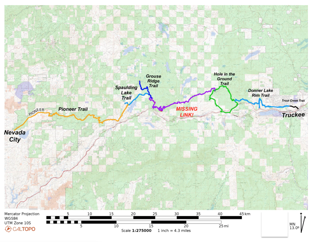
MOTHER LODE TRAILS
  • Home
  • About
  • Contact
  • Volunteer
  • Links
    • Law Enforcement Emergency
    • Federal, State, County Districts Parks & Trails
    • Running Clubs
    • Equestrian Clubs
    • Mt. Bike Clubs
    • Hiking Clubs
    • Trail Advocacy Organizations
    • Phone Numbers State & Federal Parks, Trails & Lands
    • Where to Eat on the Trails
  • News
  • Alerts

Nevada County Launches Trail Finder App, proclaims June as "Celebration of Trails" month

6/1/2023

 
Picture
The Nevada County Board of Supervisors proclaimed June 2023 as “Celebration of Trails Month” in Nevada County, which recognizes the incredible benefits trails provide local residents and visitors. To celebrate, the County is launching the new Nevada County Trail Finder App to help users discover public access trails throughout Nevada County. 

The Nevada County Trail Finder App serves as a recreational resource for connecting people with the outdoors and vast network of trails in Nevada County. The mobile-responsive app utilizes GIS datasets that identify managing agencies, surface types, and permitted uses – like hiking, biking, equestrian and off-highway vehicles. Agencies and organizations that own and manage these trails include the County of Nevada, City of Grass Valley, City of Nevada City, Town of Truckee, California State Parks, California Department of Fish and Wildlife, Tahoe National Forest, Bureau of Land Management, Pacific Gas & Electric and Bear Yuba Land Trust with direct links provided for more detailed information about each trail.

Last month, Nevada County Staff organized the annual Adopt-a-Trail cleanup on Hirschman Trail to get ready for this month’s “Celebration of Trails” activities hosted by Bear Yuba Land Trust (BYLT) to include the 1st Annual Summer Star Hike Challenge, Art in Nature installations at Hirschman and Cascade Canal Trails, and Street Party in downtown Nevada City on June 24th. The non-profit organization has built and maintains over 45 miles of trails in Western Nevada County. Their goal is to connect people to nature and provide connectivity of trail systems to make non-motorized transportation options a reality. BYLT has partnered with state, federal, and local agencies and works with private landowners to secure trail easements to allow public access across these properties. For more details, visit BYLT.org
And make sure to thank trail ambassadors from BYLT and the non-profit Truckee Trails Foundation, in eastern Nevada County, who educate users about trail etiquette and recreating responsibly. Both are supported by the Nevada County Outdoor Visitor Safety Fund, to promote public health and safety during peak visitation periods.
To sign up for Nevada County Recreation News and access the new Trail Finder App, please visit www.NevadaCountyCA.gov/Recreation.


Tahoe National Forest extends seasonal road and trail closures

5/27/2023

 
Picture
NEVADA CITY, Calif. (May 26, 2023) — Tahoe National Forest has extended its seasonal road and trail closures through June 15, 2023. Closed routes are located generally above 5,000-feet elevation with closures necessary due to overly wet conditions and existing snowpack. The closures aim to protect trails and roadbeds from additional resource damage, reduce maintenance costs and protect water quality. 

The forest has responded to several calls of individuals getting stuck in ruts, snow or muddy trail conditions. The closures outlined below are also an effort to reduce the impact on federal, state and local law enforcement partners, search and rescue and emergency medical services. 


“We have surveyed higher elevation roads and trails on the Tahoe National Forest and found significant late-season soil saturation, standing water and snow drifts on several routes,” said Tahoe National Forest Trails Program Manager Joe Chavez. “We found evidence of individuals driving on overly saturated routes and even off designated routes to get around snow and standing water at times, causing significant damage to roads and often getting stuck. The extension of the seasonal closure on impacted routes will reduce further resource damage and needed repairs to our roads and trails.” 
The Tahoe National Forest Motor Vehicle Use Maps are available here and outline what types of motor vehicles are allowed on National Forest roads and trails and when and where they are allowed. Not all closed routes are blocked with gates or closure signage. Routes that are free from snow may be passable in the morning but thaw and be impassible as the day progresses.  
Motorized vehicles are prohibited on the following routes until June 15, 2023 unless conditions allow for the termination of the closure order on an earlier date: Sierraville Ranger District  
1. Forest Road 86 (Meadow Lake Road) 
2. Forest Road 88 (Bald Ridge Loop Road) 
3. Forest Road 70 (Pass Creek Loop) 
4. Forest Road 12 (Yuba-Webber Road) 
5. Forest Road 7 west of the 12 Road intersection to its terminus at Sierra County Road 301 (Henness Pass Road or Jackson Meadows Road) 
6. Forest Road 07-40 Road (Lake of the Woods Road) 
7. Forest Road 54 (Williams Creek Road) 
8. Forest Road 04 (Bear Valley Road) 
9. Forest Road 860-35 (Babbitt Lookout) 
10. Forest Road 860-33 (Trosi Canyon) 

To see original article in the  Sierra Rec Magazine here:

​https://sierrarecmagazine.com/tahoe-national-forest-extends-seasonal-road-and-trail-closures/

New 39-space lot for Martis Valley Trail visitors

5/27/2023

 
Picture
U.S. ARMY CORPS OF ENGINEERS SACRAMENTO DISTRICT NEWS RELEASE
  SACRAMENTO, Calif. --In coordination with Placer County and the Northstar Community Services District, the U.S. Army Corps of Engineers opened a new parking lot at Martis Creek Dam and Lake on May 19.

Located directly across HWY 267 from Martis Dam Road, the new 39-space lot provides safer entry and exit for Martis Valley Trail visitors.

Minor construction activities are still underway, so some areas of the new parking lot may be blocked off from the public for visitor and worker safety. The dirt parking area currently in use will be permanently closed on June 9.

Martis Creek Lake is nestled in the Sierra Nevada Mountains near Lake Tahoe outside the town of Truckee. It was created upon the completion of Martis Creek Dam in 1972. The scenic campground has quiet, shaded, well-spaced campsites and is close to the large variety of activities offered by the Lake Tahoe-Truckee area during the summer.

If you are heading to the lake soon, please wear a life jacket. It takes an adult only about 60 seconds to drown without a life jacket. If you won’t wear it for yourself, wear it for those who love you.

To see the original release CLICK HERE.
========
​
Placer welcomes new Martis Valley Trail to North Lake TahoePublished on Aug. 17, 2021
Placer County yesterday celebrated the grand opening of the Martis Valley Trail in North Lake Tahoe.
The project will ultimately become part of the Resort Triangle Trail, which, when complete, will consist of 62 miles of trails connecting the communities of Kings Beach, Tahoe City, Olympic Valley, Truckee, Martis Valley and Northstar in a great big loop trail. 


The 4.6-mile paved pathway connects the Town of Truckee through the Martis Valley to Northstar Drive, enabling pedestrians and bicyclists the ability to easily trek between these two popular destinations. 

“I am ecstatic to see the trail’s completion and pleased that it goes through such a beautiful portion of the Martis Valley.” said Mike Staudenmayer, NorthStar Community Services District general manager.  “There was a time when we feared the trail would run alongside Highway 267 and thankfully better minds prevailed. I look forward to watching generations to come enjoy the nature that surrounds this pathway.”

The project is a collaboration between Placer County and Northstar Community Services District and includes partnerships with the United States Army Corp of Engineers, Truckee Donner Land Trust and Northstar California /Vail Resorts. United States Congressman Tom McClintock was instrumental in gaining final approval for the project.

Washoe Tribe members were also consulted to understand their rich history and concerns with cultural preservation. With continuing input from the Tribe, the project incorporates protections of cultural resources and conveys the story of the Tribe’s rich history in the Martis Valley through interpretive kiosks on the trail.

The project will ultimately become part of the Resort Triangle Trail, which, when complete, will consist of 62 miles of trails connecting the communities of Kings Beach, Tahoe City, Olympic Valley, Truckee, Martis Valley and Northstar in a great big loop trail. The trail will be paved and separated from highways and roads to maximize the safety and experience of trail users.

“This day represents one more leap forward towards achieving the Resort Triangle trails network,” said District 5 Supervisor and Board Chair Cindy Gustafson. “Our vision for a 62-mile loop that connects all of the destinations in our region is a huge endeavor and the progress we make must be celebrated to encourage our next generation to champion the cause.”

https://www.placer.ca.gov/8216/Martis-Valley-Trail


Bear Yuba Land Trust: 9th Annual Celebration of Trails Month of June

5/26/2023

 
Picture
Join Bear Yuba Land Trust (BYLT) for the 9th Annual Celebration of Trails Month!
Trail users of all ages and abilities are invited to join us as we explore our local trails! This year’s month-long event includes the first ever Summer Star Hike Challenge where folks will use their eagle-eye to spot stars along the trails and a chance to win raffle prizes (preregistration required); Art in Nature installations with site-specific artworks created by local artists; and a kick-off Happy Hour with Three Forks Bakery & Brewery Co. featuring their limited release Happy Hiker Hefeweizen. Because it isn’t a celebration without a party, the Celebration of Trails Month culminates on June 24 with a FREE Street Party along Commercial Street in downtown Nevada City, with live music from Moody Cat, awards, raffles, and more! 

First Annual Summer Star Hike Challenge
A fundraiser for Bear Yuba Land Trust
Pre-registration required
June 1 -21, 2023
Hike for the stars and support local trails with BYLT’s first ever Summer Star Hike Challenge! With 15 stars hidden along 12 local trails, this is a great opportunity for the whole family to get out to their favorite trails or discover something new. Registered participants receive a “Star Map” to guide their hikes to as many star locations as possible, with many chances to win exciting prizes. Pre-registration for this event is required: registration is $25 per person, $15 for participants under 18. All proceeds from the Star Hike Challenge support the programs and mission of Bear Yuba Land Trust.

Cheers To Local Trails Happy Hour: A National Trails Day Celebration
Three Forks Bakery & Brewery Co. in Downtown Nevada City
Saturday, June 3, 2023; 4-6pm
Toast local trails at Bear Yuba Land Trust’s National Trails Day happy hour on Saturday, June 3, with a no host bar at Three Forks Bakery & Brewery Co. The event will feature Three Forks’ limited-release, Happy Hiker Hefeweizen, available for purchase during the event and throughout the entire month of June. For every pint purchased, Three Forks will donate $1 back to local trails! 

Art In Nature Installations
BYLT proudly presents site-specific works by local artists Andres Amador and Mekdela Maskal, on view throughout the month of June at Hirschman Trail and Cascade Canal respectively.
June 1, 2023, 10am-2pm; on view through the end of June.
The community is invited to witness the creative process of landscape artist Andres Amador first hand during the install of his work “Still Here” at Hirschman Trail. A continuation of a collaboration between Andres and C.H.I.R.P., for whom he has created several clay paintings in natural settings of Nisenan basket patterns, “Still Here” draws further on the theme of endurance of the Nisenan, who are still present in the community despite the genocide they faced. The created artwork will be on view on Hirschman trail throughout the summer.
Prayer Flags by Mekdela Maskal
Cascade Trail
June 1, 2023 through through the end of June.
The installation by Mekdela Maskal features naturally dyed celebration/prayer flags strung bough to bough along Cascade Trail. Of her work, Maskal says, “Prayer is a collaboration with the more than human world. Prayer will evolve with sun time, wind and moisture, celebrating the elements and beings at work creating a balanced ecosystem. Prayer beckons us to pause in awe. Prayer is a mirror of the life that endlessly grows and dies around us, inviting us to reflect on our own transient nature and what we leave behind.”

Celebration of Trails Street Party
Commercial Street, Downtown Nevada City
Saturday, June 24, 2023, 4-8pm
Join Bear Yuba Land Trust when they take over Commercial Street in Downtown Nevada City for a blowout street party! This FREE event features local band Moody Cat performing live in front of Crazy Horse, booths staffed by local recreation partners, family activities, and more! Winners of the Summer Star Hike Challenge will be announced, and prizes won.

Celebration of Trails Sponsors & PartnersSponsors:
AJA Video Systems
The Onyx
Telestream
Three Forks Bakery & Brewery Co.
Weiss Landscaping
Yuba Water Agency
Partners:
Klean Kanteen
The National Exchange Hotel
Peak Design
Reel Anglers Fly Shop
REI
Trkac
You Bet! Bicycle Sales and Service
Special thanks to Neighborhood Center of the Arts (NCA) for creating the beautiful star art for our challenge.
When: June 1 – 30, 2023
Where: Trails across Nevada County and one trail in Yuba County
Happy Hour: June 3, 2023, 4pm-6pm; Three Forks Bakery & Brewery Co., Nevada City
Street Party: June 24, 2023, 4pm-8pm; Commercial Street, Nevada City
More Info: bylt.org/events; info@bylt.org; 530-272-5994 x208
About Bear Yuba Land TrustBear Yuba Land Trust protects and defends the working and natural lands in the Bear and Yuba River watersheds and empowers a healthy, resilient community through nature access and education.

https://yubanet.com/regional/bear-yuba-land-trust-9th-annual-celebration-of-trails-month/

Stay Out, Stay Alive: South Yuba River Public Safety Cohort Stresses Unsafe Conditions at the River

5/26/2023

 
Picture
Every year, first responders receive several calls for service for visitors who have an accident at the South Yuba River due to slips and falls. Swift water rescues are performed many times through the summer months due to unsafe river conditions. 
“Our Yuba River is majestic, but she’s also unforgiving, and it only takes an instant to lose a life,” said District 4 Supervisor Sue Hoek, who chairs the South Yuba River Public Safety Cohort meetings with District 1 Supervisor Heidi Hall.
This year, high water flows have already taken one life and are modeling similarly to high river flows in 2019, when multiple lives were lost in June alone due to visitors and locals recreating in dangerous river conditions.  
“From now through July, please avoid getting into the river at all costs. When you enter the water at this temperature and these flows, the consequences can be dire,” said Nevada County Consolidated Fire District Operations Chief Pat Sullivan. “One cubic foot of water weighs 64 lbs. We are currently seeing above 5,000 cubic feet of water and force in the South Yuba River every second, compared to average yearly highs of about 2,000 to 3,000 feet which are still considered dangerously high.”
Nevada County Consolidated Fire District conducted a river rescue training last week with California Highway Patrol’s helicopter simulating a patient recovery in the South Yuba River canyon. 

Skip the Dip
Instead of swimming in dangerous river conditions, residents and visitors are encouraged to swim, paddle, or boat at Nevada County’s beautiful recreational lakes, explore area trails, and shop or dine locally. Find ideas on Nevada County events, activities, and your next adventure at www.GoNevadaCounty.com. 
If you’re recreating along the South Yuba River, remember that you are in a remote location with minimal to no cell phone service, with fifteen-to-forty-five-minute response times. Emergency call boxes are available at Edwards, Purdon, and Highway 49 river crossings. Please also obey parking signage and only park in designated areas, so emergency response vehicles can access remote areas and narrow roadways if needed to respond to an accident.
Volunteer as a Yuba River Ambassador
From Memorial Day weekend to Labor Day weekend, South Yuba River Citizens League’s (SYRCL) River Ambassadors are volunteers taking action to motivate and educate the community to care for the South Yuba River. Due to fast currents and cold-water temperatures, educating the public on safe recreation at the river is even more important than ever. River Ambassador volunteers act as a first line of defense in helping avoid river-related tragedies. Learn more about volunteering on SYRCL’s website at www.YubaRiver.org or by contacting Cynthia Ruelas at (530) 265-5961 ext. 212 or outreach@yubariver.org.

About the South Yuba River Public Safety Cohort
The Cohort is a multi-agency working group of federal, state, local, and community stakeholders coordinating public safety and law enforcement in the South Yuba River corridor of Nevada County, which experiences approximately 800,000 visitors annually. Organizations and agencies include the County of Nevada, California State Parks, Bureau of Land Management, U.S. Forest Service Tahoe National Forest, CAL FIRE, Nevada County Consolidated Fire District, SYRCL,
Sierra Gold Parks Foundation, Bear Yuba Land Trust, and more.
​Learn more at www.NevadaCountyCA.gov/SouthYubaSafety. 


Scenic Guided Hike Along the South Fork of the American River this Sunday

5/25/2023

 
Picture
From Folsom Lake SRA administration: Making plans for Memorial Day weekend? How about you take a hike with us?
Led by Horacio Porath, Interpretive Senior Park Aide, this hike along the South Fork of the American River will cover 3.5 miles, or 5 miles depending on how long you would like to go. The trail will lead us through beautiful Oak woodlands, an experimental grove of higher elevation evergreens, beautiful vistas, and great views of the river. We will stop and admire any interesting plants and animals we find along the way, but this hike will overall not be slow-paced.
Expect this to be a moderately difficult hike, mostly flat with a few ups and downs. The trail is unpaved and there are some sections of uneven and rocky ground. There will be a mix of full sun and shade throughout the journey.
• Parking & Meeting location: Monte Vista Trailhead, in the large Falcons Crest Ln. parking area at the intersection of Salmon Falls Rd and Old Salmon Falls Rd. Parking is free in the Falcon’s Crest lot.
• Length of hike in miles: ~3 miles
• Recommended minimum age for children: 7 and up. Children must be accompanied by an adult.
• Preparation: Please be prepared for hiking by bringing water, snacks/ a lunch, closed toed shoes with treads (like a hiking shoe), and sun protection (sunscreen, hat). Binoculars and cameras are encouraged but not required.
For RSVP, questions, or concerns, please contact Horacio by email Horacio.Porath@parks.ca.gov, or call 916-856-8952. 

​For more information, CLICK HERE.


Free admission for 130 State Parks for Veterans on Memorial Day

5/22/2023

 
Picture
SACRAMENTO, Calif.— California State Parks is honoring the service of veterans, and active and reserve military members, by offering free admission to 130 participating state park units on Memorial Day – Monday, May 29, 2023. 

Participating State Park Units for Free Admission for Veterans, Active and Reserve Military Members – Memorial Day, Monday, May 29, 2023 

*Veterans, active duty and reserve military personnel must show a valid military ID, or proof of discharge other than dishonorable or bad conduct, in order to receive the free admission. 
(Parks in BOLD are local to us.)


  1. Anderson Marsh State Historic Park (SHP)
  2. Andrew Molera State Park (SP)
  3. Angel Island SP
  4. Annadel SP
  5. Año Nuevo SP
  6. Antelope Valley CA Poppy Reserve State Natural Reserve (SNR)
  7. Anza-Borrego Desert SP
  8. Auburn State Recreation Area (SRA)
  9. Benbow Lake State SRA
  10. Benicia SRA
  11. Bidwell-Sacramento River SP
  12. Bolsa Chica State Beach (SB)
  13. Bothe-Napa Valley SP
  14. Bethany Reservoir
  15. Calaveras Big Trees SP
  16. California Citrus SHP
  17. California State Railroad Museum
  18. Cardiff SB
  19. Carlsbad SB
  20. Carnegie State Vehicular Recreation Area (SVRA)
  21. Carpinteria SB
  22. Castle Crags SP
  23. Castle Rock SP
  24. Caswell Memorial SP
  25. China Camp SP
  26. Chino Hills SP
  27. Clay Pit SVRA
  28. Clear Lake SP
  29. Colonel Allensworth SHP
  30. Colusa-Sacramento River SRA
  31. Crystal Cove SP
  32. Cuyamaca Rancho SP
  33. Doheny SB
  34. Donner Memorial SP
  35. Eastern Kern County Onyx Ranch SVRA
  36. Ed Z’Berg Sugar Pine Point SP
  37. El Capitan SB
  38. Emerald Bay SP
  39. Emma Wood SB
  40. Folsom Lake SRA
  41. Folsom Powerhouse SHP
  42. Fort Ross SHP
  43. Fort Tejon SHP
  44. Fremont Peak SP
  45. George J. Hatfield SRA
  46. Grover Hot Springs SP
  47. Half Moon Bay SB
  48. Hendy Woods SP
  49. Henry Cowell Redwoods SP
  50. Henry W. Coe SP
  51. Hollister Hills SVRA
  52. Humboldt Redwoods SP
  53. Hungry Valley SVRA
  54. Huntington SB
  55. Indian Grinding Rock SHP
  56. Jack London SHP
  57. Jedediah Smith Redwoods SP
  58. Kenneth Hahn (Baldwin Hills Scenic Overlook only)
  59. Kings Beach SRA
  60. La Purisima Mission SHP
  61. Lake Oroville SRA
  62. Lake Perris SRA
  63. Leo Carrillo SP
  64. Los Angeles SHP
  65. Malakoff Diggins SHP
  66. Malibu Creek SP
  67. Malibu Lagoon SB
  68. Manresa SB
  69. Marshall Gold Discovery SHP
  70. McArthur-Burney Falls Memorial SP
  71. McConnell SRA
  72. Millerton Lake SRA
  73. Mono Lake Tufa SNR
  74. Morro Bay SP
  75. Mount Diablo SP
  76. Mount San Jacinto SP
  77. Mount Tamalpais SP
  78. Natural Bridges SB
  79. New Brighton SB
  80. Oceano Dunes SVRA
  81. Pacheco SP
  82. Palomar Mountain SP
  83. Sue-meg SP
  84. Pescadero SB
  85. Pfeiffer Big Sur SP
  86. Picacho SRA
  87. Pismo SB
  88. Point Lobos SNR
  89. Point Mugu SP
  90. Pomponio SB
  91. Portola Redwoods SP
  92. Prairie City SVRA
  93. Prairie Creek Redwoods SP
  94. Providence Mountains SRA
  95. Railtown 1897 State Historic Park
  96. Red Rock Canyon SP
  97. Refugio SB
  98. Richardson Grove SP
  99. Robert H. Meyer Memorial SB
  100. Russian Gulch SP
  101. Saddleback Butte SP
  102. Salt Point SP
  103. Salton Sea SRA
  104. Samuel P. Taylor SP
  105. San Buenaventura SB
  106. San Clemente SB
  107. San Elijo SB
  108. San Gregorio SB
  109. San Luis Reservoir SRA
  110. San Onofre SB
  111. Seacliff SB
  112. Silver Strand SB
  113. Silverwood Lake SRA
  114. Sinkyone Wilderness SP
  115. South Carlsbad SB
  116. South Yuba River SP
  117. Standish Hickey SRA
  118. Sugarloaf Ridge SP
  119. Sunset SB
  120. The Forest of Nisene Marks SP
  121. Tomales Bay SP
  122. Topanga SP
  123. Torrey Pines SB
  124. Torrey Pines SNR
  125. Tule Elk SNR
  126. Turlock Lake SRA
  127. Van Damme SP
  128. Wilder Ranch SP
  129. Will Rogers SHP
  130. William B. Ide Adobe SHP
Go here to see this information at the CA State Parks website.
https://www.parks.ca.gov/?page_id=30600&utm_medium=email&utm_source=govdelivery

Updated Hidden Falls reservation and park information

5/18/2023

 
Picture
5/18/23
​Reservations are required on all weekends.  In addition, the following days during 2023 will require a parking reservation:

Remaining 2023 High Usage Dates:  5/29, 7/4, 9/4, 10/9, 11/10, 11/23 - 11/24, 12/18 - 1/5. 

Additionally,

HIDDEN FALLS REGIONAL PARK TO CLOSE ON DAYS OF EXTREME FIRE WEATHER
As part of our land stewardship and commitment to reducing wildfire risk, Hidden Falls Regional Park will be closed to public access during days that are determined to be extreme fire weather. Notice will be given as far in advance of closure days as possible but may be as short as 12 hours’ notice before closure the following day.  Please check the status on our webpage immediately before leaving on your visit to Hidden Falls this summer.  Visitors with reservations during closure days will be given credit for the purchase price of their reservation to be used for a future visit. 

WHERE CAN I CHECK THE CLOSURE STATUS BEFORE MY VISIT TO HIDDEN FALLS?
Notifications will be posted to the following website:
https://www.placer.ca.gov/6106/Hidden-Falls-Regional-Park 
or by calling (530) 886-4901.
​You may also check our social media sites for updates.

HOW WILL CLOSURE DAYS BE DETERMINED?
Staff will determine extreme fire weather days in consultation with weather and fire officials and would generally coincide with conditions that prompt Red Flag and Excessive Heat warnings.

Hidden Falls Regional Park
7587 Mears Place

Auburn, CA 95602
Hours
The park is open from sunrise to sunset daily. Specific opening and closing times are posted daily by park rangers at the site. 


Forest Service anticipates delayed spring openings at Lake Tahoe

5/4/2023

 
Picture
SOUTH LAKE TAHOE, Calif. — Spring conditions in the Lake Tahoe Basin have finally arrived, but our epic winter will likely delay the official opening of many National Forest recreation sites including beaches, campgrounds, forest roads and trailheads. We encourage patience and understanding as we work through the process of opening these sites.
Photo provided/Charlie Westerhold/Tahoe Recreation

“The Forest Service is aware of the public’s desire to access National Forest recreation sites as early as possible,” said LTBMU Deputy Forest Supervisor, Vicki Lankford. “We make every effort to open sites as soon as they are deemed safe for the public, we have adequate staffing on board, and can ensure precious natural resources will be protected.”

Before recreation sites can be fully opened to the public, the Forest Service must complete seasonal hiring of crews and staff to manage sites, clean up from winter, remove safety hazards such as damaged trees, and wait for the danger of a freeze to pass before turning on water systems for restrooms. 

In a typical year, campgrounds, beaches, forest roads and trailheads start becoming accessible beginning in mid-May. This year, delays are unavoidable particularly in shaded areas such as Emerald Bay, north and west shores, and higher elevations. Snow in these areas will take longer for to melt and there is always the possibility we may receive additional snow. Sunny areas such as the east and south shores usually melt out earlier, but some delays are still possible. The Taylor Creek Visitor Center and Tallac Historic Site are scheduled to open around Memorial Day.

Backcountry and wilderness access will also be a challenge this year. We urge visitors to these areas to plan ahead for limited parking, snow and ice on trails and always be prepared with proper knowledge, equipment, clothing and footwear. 

Until sites officially open, there is no parking, trash removal or restroom facilities available, so please plan accordingly. Do your part and pack out all trash and where pets are allowed, always clean up after them. Where gates are still closed, be sure to park vehicles completely off the roadway, avoid parking on vegetation, and do not block the gates.

 - Lisa Herron is public affairs office for the Lake Tahoe Basin Management Unit.

CLICK HERE to see the original article in the Tahoe Daily Tribune

First Annual Summer Star Hike Challenge - A Fundraiser for Bear Yuba Land Trust Trails

5/1/2023

 
Picture
Join BYLT for our 1st Annual Summer Star Hike Challenge A Fundraiser for Bear Yuba Land Trust Trails
How it works:
There will be 14 hidden paper mache stars hanging from trees on 12 of Bear Yuba Land Trust’s hiking trails. Use the Star Map and visit as many different star locations as possible from June 1st- June 21st to be entered to win exciting prizes and celebrate your local trails!
Entry Rules:
  1. Visit as many of the trail locations as you can and find the trees with hanging stars
  2. Scan the QR code and fill in your information on the form to submit your entry. Each star you find and submit = one entry. (If you do not have service, take a photo of the QR code and you can place your entry when you return to an area with service)
  3. The more stars you find the greater your chances to win!
  4. Entries will be accepted until midnight on June 21st any entries after this time will not be counted
To win bonus entries into the prize drawings:
  1. Take a selfie with each star and tag BYLT with #summerstarhikechallenge
    (participant’s social media account must be set to public or we will not be able to see your tagged photos)
  2. Correctly I.D. each tree species that the stars are hanging from when you submit your entry form.
T-Shirt pick-up and Summer Star Hike raffle prize winners will be announced at BYLT’s Celebration of Trails Street Party on June 24th

REGISTER NOW
Adult registration- $25 per person 
Youth registration (under 18) – $15 per person

All registrations include entry into the Summer Star Hike Challenge, a 2023 Summer Star Hike Challenge T-shirt, and a Star Map to help locate the stars.
*Registrations after June 3rd T-shirt sizes are subject to availability*

Raffle Prizes:Grand Prizes: ( Must visit at least 6 trails to qualify for Grand Prizes)
  • 1 Night stay at Holbrooke Hotel and The National Hotel
  • 1-1/2 day guided fishing trip for 2 from Reel Anglers Fly Shop
  • REI Gift Pack
Second Prizes:
  • 2 Peak Design Backpacks
  • Klean Kanteen Bundle
  • Big BYLT Merch Bundle (Including 7 of BYLT’s best merch items)
  • Troy Lee Designs Bike Helmet
Thank you to our sponsors! 

Go here for entry form!

https://www.bylt.org/events/event/2023-celebration-of-trails-summer-star-hike-challenge/
<<Previous

    Archives

    May 2023
    April 2023
    March 2023
    February 2023
    January 2023
    December 2022
    November 2022
    October 2022
    September 2022
    August 2022
    July 2022
    June 2022
    May 2022
    April 2022
    March 2022
    February 2022
    January 2022
    December 2021
    November 2021
    October 2021
    September 2021
    August 2021
    July 2021
    June 2021
    May 2021
    April 2021
    March 2021
    February 2021
    January 2021
    December 2020
    November 2020
    October 2020
    September 2020
    August 2020
    July 2020
    June 2020
    May 2020
    April 2020
    March 2020
    February 2020
    January 2020
    December 2019
    November 2019
    October 2019
    September 2019
    August 2019
    July 2019
    June 2019
    May 2019
    April 2019
    March 2019
    February 2019
    January 2019
    December 2018
    November 2018
    October 2018
    September 2018
    August 2018
    July 2018
    June 2018
    May 2018
    April 2018
    March 2018
    February 2018
    January 2018
    December 2017
    November 2017
    October 2017
    September 2017
    August 2017
    July 2017
    June 2017
    May 2017
    April 2017
    March 2017
    February 2017
    January 2017
    December 2016
    November 2016
    October 2016
    September 2016
    August 2016
    July 2016
    June 2016
    May 2016
    April 2016
    March 2016
    February 2016
    January 2016
    December 2015
    November 2015
    October 2015
    September 2015
    August 2015
    July 2015

    Categories

    All

    RSS Feed

Home
Contact
 Mother Lode Trails is YOUR local volunteer-run trail information and resource website. Here you can find
up-to-the minute information on trail alerts, links and trail news for Placer,  Yuba, and Nevada counties.
Mother Lode Trails is trademarked.