MOTHER LODE TRAILS
  • Home
  • About
  • Contact
  • Volunteer
  • Links
    • Law Enforcement Emergency
    • Federal, State, County Districts Parks & Trails
    • Running Clubs
    • Equestrian Clubs
    • Mt. Bike Clubs
    • Hiking Clubs
    • Trail Advocacy Organizations
    • Phone Numbers State & Federal Parks, Trails & Lands
    • Lost & Found on the Trails
    • Where to Eat on the Trails
  • News
  • Alerts

Little Grass Valley Reservoir camp water source depleted

6/30/2021

 
Picture
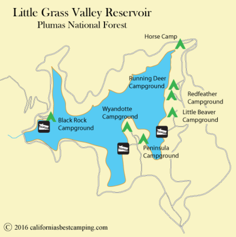
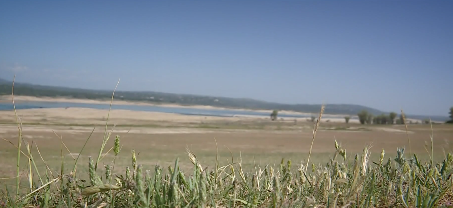
Due to the severe drought conditions, the water source that supports the following recreation sites at Little Grass Valley Reservoir, near La Porte, CA, has been depleted.

The sites are Running Deer, Red Feather, and Little Beaver Campgrounds; as well as Blue Water Beach Day Use Area and Maidu Boat Launch.

Visitors should plan to bring plenty of drinking water and fill up RVs and trailers at home if visiting or camping at any of these recreation sites at Little Grass Valley Reservoir.


Western States 100 run this weekend June 26-27, 2021

6/25/2021

 
Picture
The Western States 100-Mile Endurance Run is the world’s oldest 100 mile trail race. The Run starts in Olympic Valley, California, near the site of the 1960 Winter Olympics, and ends 100.2 miles later in Auburn, California. In the decades since its inception in 1974, Western States has come to represent one of the ultimate endurance tests in the world.
Traversing the traditional lands of the Nisenan, Washoe, and other neighboring Indigenous Peoples, the Western States Trail climbs more than 18,000 feet and descends nearly 23,000 feet before runners reach the finish at Placer High School in Auburn. In the miles between Olympic Valley and Auburn, runners experience the majestic high country of Emigrant Pass and the Granite Chief Wilderness, the crucible of the canyons of the California gold country, a memorable crossing of the ice cold waters of the Middle Fork of the American River, and finally the historic reddish brown trails that led many travelers, including gold prospectors, to Auburn.
For almost five decades, Western States has been home to some of the sport’s most stirring and legendary competitions. With more than 1,500 dedicated volunteers helping to create a once-in-a-lifetime experience, the Run has stirred the spirit of runners from all walks of life, from all over the globe.
Offering the sport’s oldest and most prized possession – a sub-24-hour silver belt buckle and a sub-30-hour bronze belt buckle – Western States remains one of the undisputed crown jewels of human endurance.

If you are not part of the race, PLEASE USE ALTERNATE TRAILS THIS WEEKEND.


​https://www.wser.org/

Folsom Lake lowest in June since 1977, campsites and trails open

6/18/2021

 
Picture
June is historically high time for Folsom Lake recreation, as the Sierra Nevada snowpack "water bank" empties the vault under the spring sun. Folsom boat launches are regular bee hives in June, while teen sunbathers crowd Granite Beach.
But a second weak snowpack in a row puts the 63-year-old reservoir in dire straits, the lowest point this time of year since the 1977 drought. Granite Beach is high and dry, with the water's edge a good hike or car ride down the hillside.
As of this week, Folsom fell to 393 feet above sea level, or roughly 42 percent of normal, 35-percent capacity. During a normally wet precipitation year, the lake level peaks this month in the 460-foot range.
"They should never let it drain that far down," said Adelus Galus of Roseville in an online lake forum. "Very frustrating."
Just two years ago in 2019, the lake reached 464 feet in early June, after a record-breaking snowfall season. Even with the weak snowpack and runoff last year, the lake still managed to reach a somewhat healthy 449 feet last June.
This year, the reservoir already peaked a month ago May 18 at a disappointing 398 feet. Any lower isn't unknown territory, however. The Folsom water level plunged to 381 feet in late January.
Only two of Folsom's state park boat launches were still in operation as of last weekend - Granite Bay on the Placer County, American River North Fork shore and Brown's Ravine on the El Dorado County South Fork branch.
The low levels also forced a 5-mph speed limit since January on the remaining lake for those hearty boaters who decide to rough it and haul their craft down dusty, makeshift dirt roads to the distant, last launches.
Folsom Lake capacity is 977,000 acre-feet, with June normally reaching 80 to 90 percent. When full, the reservoir features 75 miles of shoreline with enough water to cover the state of Rhode Island with one and a half feet of water.
Throughout last spring, the snowpack above in the upper American River watershed showed signs pointing toward a "near normal" year. Snow was measured at 83 percent as late as April at Phillips Station or a reasonable flux of average.
Phillips Station is up near Echo Summit at the American River South Fork source, which feeds the reservoir. The American River North and Middle forks feed the Placer northwestern branch.
The State Department of Water Resources measurement at Phillips Station is widely used in the media as an annual harbinger of the entire Sierra runoff. But the South Tahoe area location turned out to be a strange anomaly this year compared to the rest of the mountain range. Surrounding snow totals in the North Tahoe region dipped to 70 percent.
Even that lower amount would still normally top off Folsom Lake much higher than where it peaked already. But as some experts loosely predicted, nearly three quarters of a million acre-feet of Sierra runoff literally disappeared on the way down the hill.
The melt never showed up because it failed to rain much last fall in order to soak the Sierra soil before snow fell, state officials said. So a good portion of the runoff went straight down into the ground. Another substantial portion simply evaporated along the way down under late spring warm temperatures, authorities said.
As of this week though, Folsom Lake State Recreation Area park entrances remained open to vehicle traffic at Rattlesnake Bar near Loomis, plus Granite Bay and Beals Point on the Placer County side. Beals includes a 69-site overnight campground.
The Folsom Point, Brown's Ravine (Folsom Lake Marina), Darrington Trailhead, Skunk Hollow, Salmon Falls, Old Salmon Falls, Peninsula and Mormon Island entrances on the El Dorado side also remain open.
Down below Folsom Dam on Lake Natoma, the Willow Creek, Negro Bar, Nimbus Flat, CSUS Aquatic Center, Park Shore, Nimbus Overlook and Shadow Glen parks in Sacramento County remain open.
The day-use facilities and restrooms are open at all the above locations. The three campgrounds at Beals Point, Peninsula and Negro Bar are also still open, officials said.

CLICK HERE to see the original article in Gold Country Media.


Hidden Falls closed June 17-19 due to excessive heat

6/17/2021

 
Picture
Hidden Falls Regional Park in North Auburn will be closed June 17-19 due to an excessive heat warning issued by the National Weather Service. Stay safe out there! 

CLICK HERE to see Placer County's Hidden Falls updates.


Until further notice, SPI California Forestland to Close to Public Access on June 21 Due to Drought & Wildfire Danger

6/17/2021

 
Picture
Due to the extreme drought conditions and risk of wildfire, Sierra Pacific Industries (SPI) is closing its California forestlands to public access. This closure will begin Monday, June 21, and remain in effect until further notice.

“SPI takes its commitment to protecting our forest resources and public safety seriously,” said Andrea Howell, SPI spokesman. “With this year’s extreme drought conditions having substantially increased the risk of wildfire, we have made the difficult decision to close our lands to public access and recreation.”

The public’s use of SPI roads and walk-in access to their privately-owned lands will not be allowed. SPI will regularly evaluate the situation; however, it is anticipated the closure will remain in effect into Fall 2021.
​

For inquiries about the closure, contact the SPI California Public Recreation Hotline, 530-378-8274. To learn more about the company’s recreation access policies, visit 
​http://spi-ind.com/OurForests/RecreationAccess.


​

NID restricts campfires in campgrounds to reduce wildfire risk

6/16/2021

 
Picture
Fire use restrictions will go into effect Thursday, June 17, at foothill recreational facilities owned and operated by the Nevada Irrigation District (NID). Due to the drought, hot weather and dry conditions, campfires will be prohibited in developed campgrounds around Scotts Flat Reservoir and Rollins Reservoir.

Under the rules, campfires and open fires fueled by wood or charcoal are prohibited. Portable cooking stoves and propane-fueled portable fire rings are permitted because fire levels can be monitored and maintained.
“With the current drought and dry, hot conditions, fires caused by abandoned or escaped campfires pose a greater threat to our community, firefighters and the forest,” said NID Recreation Manager Monica Reyes. “Thanks to the community, campers and recreationists for understanding the need for these restrictions. Our goal is to keep everyone safe.”
Learn more about NID recreation, click here. https://nidwater.com/recreation/

To see the original article in Yubanet.net, CLICK HERE.


Enhanced fire restrictions begin June 15 in Tahoe Basin

6/15/2021

 
Picture
U.S. Forest Service - Lake Tahoe Basin Management Unit 
Enhanced fire restrictions begin June 15 at Lake Tahoe
June 15, 2021 – Enhanced fire restrictions begin today, June 15, 2021, and will remain in effect through November or until rescinded. Wood and charcoal fires and other fire-related activities are prohibited on National Forest System lands in the Lake Tahoe Basin, including developed campgrounds. Illegal campfires cause over 90 percent of the wildfires at Lake Tahoe and increased fire danger due to severe drought conditions and warm weather is a big concern this summer. Enhanced fire restrictions will help reduce the possibility of human-caused fires.

​Read more at https://go.usa.gov/x6n3f.

Temporary closure of WST from Auburn Staging Area

6/10/2021

 
Picture
STATE OF CALIFORNIA, DEPARTMENT OF PARKS AND RECREATION, GOLD FIELDS DISTRICT, AUBURN SECTOR
ORDER NO. 690 - 040 -2021
June 10, 2021
Temporary Closure - Western States Trail
A segment of the Western States Trail between the Auburn Staging Area and the Gold Street Connector, as identified on the attached map, will be temporarily closed to public entry within Auburn State Recreation Area from 6:00 a.m. to 4:00 p.m. until further notice. For the safety of the visiting public, this trail segment is closed during fuel reduction work hours. Closure notices will be posted accordingly at various trail locations.
According to Auburn SRA Superintendent Mike Howard, the closure is expected to last a week.

To see the original order, CLICK HERE.
Picture

Attempted truck/horse trailer theft at Magnolia Ranch Trailhead staging area

6/5/2021

 
Picture
Last Friday, June 4, equestrians approached the Magnolia Staging Area just in time to prevent the theft of one of the group’s truck and horse trailer. The vehicle belonging to the thieves was a gray pickup. One of them had already broken into the truck and pried off the covering on the ignition. The thieves saw the approaching group of horseback riders and quickly jumped into the gray truck and sped out of the staging area. Purse was stolen, tools were left behind. 

Please keep nothing of value in your vehicles when leaving them at the trailheads. Be sure to immediately call the Sheriff to tell them of the thefts and damage.

BLM Magnolia Ranch Trailhead is located approximately five miles north of the town of Coloma along Highway 49 and the South Fork of the American River. It is situated between the Cronan Ranch Regional Trails Park and Greenwood Creek River Access on public lands.


​
​

BLM/Oregon Trails Coalition publish online trails planning guide

6/2/2021

 
Picture
This is a 62-page informative guide for trail planning steps, "READY, SET, PLAN
An Introductory Guide to Trail Planning and Decision Making," is published by BLM and the Oregon Trails Coalition. Even though it it wasn't made for California, the planning steps are the same.

Turn a great idea for a new trail and make your vision a reality. You’ve heard that the process requires
patience and persistence, this guide explains the necessary steps. This trails planning guide was a collaboration between land managers, trail planners, and trail user groups.

The online version is free. You can download (BIG file) or read
it at Trail Planning Made Clear HERE.

    Archives

    January 2023
    December 2022
    November 2022
    October 2022
    September 2022
    August 2022
    July 2022
    June 2022
    May 2022
    April 2022
    March 2022
    February 2022
    January 2022
    December 2021
    November 2021
    October 2021
    September 2021
    August 2021
    July 2021
    June 2021
    May 2021
    April 2021
    March 2021
    February 2021
    January 2021
    December 2020
    November 2020
    October 2020
    September 2020
    August 2020
    July 2020
    June 2020
    May 2020
    April 2020
    March 2020
    February 2020
    January 2020
    December 2019
    November 2019
    October 2019
    September 2019
    August 2019
    July 2019
    June 2019
    May 2019
    April 2019
    March 2019
    February 2019
    January 2019
    December 2018
    November 2018
    October 2018
    September 2018
    August 2018
    July 2018
    June 2018
    May 2018
    April 2018
    March 2018
    February 2018
    January 2018
    December 2017
    November 2017
    October 2017
    September 2017
    August 2017
    July 2017
    June 2017
    May 2017
    April 2017
    March 2017
    February 2017
    January 2017
    December 2016
    November 2016
    October 2016
    September 2016
    August 2016
    July 2016
    June 2016
    May 2016
    April 2016
    March 2016
    February 2016
    January 2016
    December 2015
    November 2015
    October 2015
    September 2015
    August 2015
    July 2015

    Categories

    All

    RSS Feed

Home
Contact
 Mother Lode Trails is YOUR local volunteer-run trail information and resource website. Here you can find
up-to-the minute information on trail alerts, links and trail news for Placer,  Yuba, and Nevada counties.
Mother Lode Trails is trademarked.