MOTHER LODE TRAILS
  • Home
  • About
  • Contact
  • Volunteer
  • Links
    • Law Enforcement Emergency
    • Federal, State, County Districts Parks & Trails
    • Running Clubs
    • Equestrian Clubs
    • Mt. Bike Clubs
    • Hiking Clubs
    • Trail Advocacy Organizations
    • Phone Numbers State & Federal Parks, Trails & Lands
    • Where to Eat on the Trails
  • News
  • Alerts

Bears seen in Lone Grave and Skillman Horse Camp area trails

6/29/2020

 
Picture
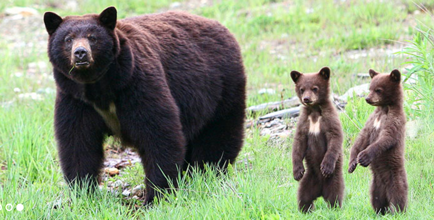
A solo horseback rider surprised a yearling bear on one the Lone Grave area trails north of Nevada City on the Highway 20 corridor. The young bear who upon seeing the rider quickly left the area.  Another rider has seen a mama bear and two cubs in the Skillman Camp area. Do be aware that bears are active at that elevation. If trail users talk or use bear bells, the bears normally leave the area. 

Tahoe National Forest UPDATE on openings: June 26 - July 2

6/28/2020

 
Picture
Nevada City, Calif. June 26, 2020 – The Tahoe National Forest is increasing access to the public by providing additional developed recreational opportunities. We encourage visitors to check our website and social media pages for the most up-to-date information on what is open so that you can plan your visit.
All visitors are encouraged to recreate responsibly and to practice self-sufficiency during while visiting the Tahoe National Forest. This includes:
• Maintaining at least six feet distancing from others
• Do not gather in groups and please follow the latest guidance from officials
• Communicate with others as you pass. Alert trail users of your presence and step aside to let others pass
• Pack out your trash and leave with everything you bring in and use.
• All services may not be available, so please plan accordingly.
The Tahoe National Forest will continue to phase in opening of facilities and services as county policies and facility preparations allow. For complete list of current updates, please see below.

Campgrounds

The following campgrounds are open. All campgrounds are 90% reserved unless indicated:
  • Highway 89, South
    • Goose Meadow Campground
    • Granite Flat Campground
    • Silver Creek
  • Foresthill Divide Road
    • Giant Gap Campground
    • Shirttail Campground
    • Mumford Bar (First Come First Served only)
  • Gold Lake Road
    • Berger
    • Diablo
    • Packsaddle (Water systems under repair, campers must pack in water)
    • Salmon Creek 
    • Sardine 
    • Snag Lake
  • Marysville Road
    • Dark Day Campground
    • Garden Point Campground (boat in)
    • Madrone Cove Campground (boat in)
    • Schoolhouse Campground
  • Mosquito Ridge Road
    • Ahart
    • French Meadows
    • Lewis
    • Talbot (First Come First Served only)
  • Interstate 80
    • North Fork  
    • Onion Valley (First Come First Served only)
    • Hampshire Rocks (some sites closed due to hazard trees)
  • Highway 49
    • Loganville 
    • Rocky Rest
    • Carlton Flat
    • Cal Ida
    • Union Flat
  • Highway 89, North 
    • Bear Valley
    • Cold Creek
    • Cottonwood
    • Little Lasier Meadow Horse
    • Lakeside (Water systems under repair, campers must pack in water)
    • Lower Little Truckee
    • Prosser Family (Water systems under repair, campers must pack in water)
    • Upper Little Truckee
  • Boca / Stampede Reservoirs
    • Boca
    • Boca Rest
    • Boca Springs
    • Boyington Mill
    • Logger – Dump station open
  • Bowman Lake Road
    • Carr-Feeley – PG&E managed site, first-come first-serve only
    • Lindsey – PG&E managed site, first-come first-serve only
    • Grouse Ridge – Open, first-come first-serve only NO FIRES ALLOWED

The following campgrounds are closed for the upcoming weekend, June 26-28, 2020. Closing any site for any reason is not an action we take lightly, but protecting our visitors and employees remains our highest priority.
In addition, reservations have been temporarily canceled for the following closed campgrounds. If you previously made a reservation for one of the following closed campgrounds, and the campground opens before your current reservation date, your reservation will be honored. If a closed campground does not open before your reservation date, you will be refunded. Please check back in for weekly campground opening updates.
  • Interstate 80
    • Indian Springs – tentative open date August 1
  • Highway 20
    • White Cloud – tentative open date July 2
    • Skillman – tentative open date July 2
  • Highway 49
    • Chapman Creek – Closed for the season, hazard tree and road work
    • Fiddle Creek – tentative open date July 17
    • Indian Valley – tentative open date July 2
    • Ramshorn – tentative open date August 1
    • Sierra – tentative open date August 1
    • Wild Plum – tentative open date August 1
    • Yuba Pass – Closed for the season, hazard trees
  • Highway 89, North
    • Lake of the Woods – Closed due to hazard trees
  • Marysville Road
    • Frenchy Point
All group campgrounds are closed at this time. Please check back July 2 for tentative group campground opening date information:
  • Big Bend
  • Cottonwood Creek
  • Coyote – Reservations cancelled at least through July 9
  • Emigrant Gap
  • Forbes – Reservations cancelled at least through July 9
  • Gates– Reservations cancelled at least through July 9
  • Hornswoggle
  • Prosser Ranch
  • Tunnel Mills
Reservations are not available for the following campgrounds and they are currently closed:
  • Robinsons Flat (hazard trees)
  • Sterling Lake – PG&E managed site, closed for hazard tree removal
  • Meadow Lake – PG&E manages site, closed for hazard tree removal, est. opening July 3
  • Sagehen Creek
  • White Rock Lake (unreachable due to snow)

​Day Use Sites, Trailheads, Boat Ramps, and Staging Areas

All developed recreation sites on the Tahoe National Forest are now open. Trash removal services remain limited – please pack out all trash and waste. Toilet facilities remain limited, please plan accordingly.
  • Gold Lake Road
    • Sierra Buttes Trailhead – Rough conditions may exist
  • Highway 20
    • Gold Country Equestrian Trailhead – Open
    • Golden Quartz – Open
  • Highway 49
    • Oregon Creek Day Use Area – Open
  • Highway 89, North
    • Pass Creek – Open
    • Woodcamp Boat Ramp – Opens July 1
    • Donner Picnic Area – Open
  • Interstate 80
    • Indian Springs Staging Area – Open
    • Castle Valley – Inaccessible due to snow
  • Boca / Stampede Reservoirs
    • Prosser Boat Ramp – Open
    • Boca Boat Ramp – Closed due to water level
    • Stampede Boat Ramp – Open
    • Boca Town Site – Open
    • Prosser OHV – Open
    • Vista Overlook – Open
  • Marysville Road
    • Dark Day Boat ramp/picnic area – Open
    • Emerald Cove Boat ramp – Open
  • Mosquito Ridge Road
    • French Meadow Boat Ramp – Open
    • Big Trees Nature Trail – Accessible, windfall on access road and trail
  • Foresthill Divide Road
    • Manzanita – Open – $5.00 day use fee now in effect.
    • Sugar Pine Boat Launch – Open, limited parking, $5.00 day use fee now in effect.
    • Brimstone staging area – Open
    • Parker Flat OHV staging area – Open
    • Sugar Pine OHV staging area – Open
  • Bowman Lake Road
    • Carr-Feeley – accessible, free trailhead parking
    • Lindsay – accessible, free trailhead parking
    • Loney Meadows – accessible, free trailhead parking

Motorized Routes and Trails

Trash removal services remain limited at many motorized trailheads – please pack out all trash and waste. Thank you for helping to keep the Tahoe National Forest safe and clean. Happy riding!
Westside of the Tahoe National Forest
  • Sugar Pine OHV system is open. Loop 6, of the Foresthill OHV system, is closed at the “lower bridge” due to major storm damage. The trail is open on both sides but the bridge is impassable.
  •  The Downieville multiple-use trail is mostly open.  Some of the highest elevation trails may still have snow drifts blocking access (i.e., Chimney Rock, top of Gold Valley 4×4 and top of Lavezzola)
  • Fordyce Jeep Trail – Open, all snow should be melted out
  • Burlington Motorcycle Trail system – Open
  • Gold Valley OHV system  –  Log blocking 4×4 entrance, still some snow drifts on highest elevation trails
  • Excelsior – Rough conditions
  • Pendola – Open
  • Chalk Bluff – Rough conditions
  • Omega – Rough conditions
  • Alpha  – Rough conditions
  • Burlington – Rough conditions
  • Bowman  – Clear to Bowman Lake
  • Lindsey (FS 17 RD) – Clear to lake
  • Grouse Ridge (FS 14 RD) – Rough conditions from Bowman (FS 17 RD) patched of snow may exist on road near campground, proceed with caution
  • Cal-Ida – Fully accessible, rough conditions
  • Fiddle Creek – Fully accessible, rough conditions
  • Texas Hill – From Emigrant Gap clear to MP 8.5, rough conditions thereafter, 4×4 high clearance recommended. From Yuba Gap clear to MP 4.6, then rough condition thereafter.
  • Eureka  – Fully accessible, rough conditions
  • Long Point Access – Rough conditions
  • Jouberts  – Poor road condition, snow and tree limbs in road
  • Madrone Spring – Good condition
  • Washington Ridge – Good condition
  • Packer Lake Road – Clear

Eastside of the Tahoe National Forest

  • Fiberboard (07 Road) – Open  
  • Prosser Hill Moto (Animal/Animal Crackers) – open, cleared
  • Bald Mountain Moto (Happy Face) – sections of the trail and area will be closed during the summer to accommodate the Big Jack East Vegetation Project – see Big Jack East Project Story Map for project updates and closure info
  • Lloyd’s Moto – Open, cleared
  • Meadow Lake – Open and snow free
  • The Bear Valley OHV system – Open, actively being cleared of down winter trees
  • Yuba Weber  – Open and snow free
  • Carmen Valley – Road is snow free and in good condition and passable
  • Nichols Mill – Open to Jones Valley, snow beyond that
  • Verdi Peak – Open, rough conditions
  • Haskel Peak – Passable
  • Babbit – Rough Road. Road maintenance activities, watch out for heavy equipment.
  • Sawtooth (06 Road) – Open, watch out for large trucks/heavy equipment
  • Bear Valley Road – Snow free, good condition and passable
  • Sardine Road- Snow Free, clear to Sardine Lake
  • Rubicon – Snow melted out
  • Mosquito Ridge – Clear to Hell Hole
Local County Roads within the Tahoe National Forest
  • Boca/Stampede – Clear
  • Foresthill Road – Clear to Robinson Flat
  • Indian Springs Road – Clear to OHV Trail Head. Signal Peak still snowed in.
  • Gold Lake Highway – Open
  • Sierra County has closed Mountain House Road between Goodyears Bar and Henness Pass Road due to road repair work for storm damage culvert replacements.

Non-motorized Trails

Generally non-motorized trails are open, but high elevation trails may be inaccessible due to late season snow and other factors:

Below 5000’: Trails may not have been cleared. Potential for down trees and rough conditions on trails below in this elevation. This applies to:
  • Pioneer Trail
  • Bullards Bar Trail Complex
  • Joshua M. Hardt Memorial Trail – Trails have been cleared and fully accessible
  • North and South Yuba Trail – Reports of some downed trees, actively being cleared
  • Dascombe Trail Complex
  • Western States Trail – Trails have been cleared and fully accessible
5,000’ -6,000’: Trails may not have been cleared. Potential for down trees and rough conditions on trails below in this elevation. This applies to:
  • The Lone Grave area trail system has been cleared.
  • Blue Lake Trail
  • Spaulding Lake Trail
  • Forest City Trail Complex
6,000’ to 7,000’: Trails may not have been cleared. Potential for down trees and rough conditions on trails below in this elevation. This applies to:
  • Hole in the Ground Trail – not cleared, many snow patches still exist
  • Western States – open, clear east of Hwy 89 and 3 miles west of 89; still snow near the crest
  • Commemorative Overland Emigrant – open, cleared
  • Sawtooth – cleared, sections of the trail and area will be closed during the summer to accommodate the Big Jack East Vegetation Project – see Big Jack East Project Story Map for project updates and closure info
  • Big Chief – open, clear of snow, not affected by the Big Jack East Vegetation Project
  • Donkey Town/Burro (formerly Jackass Ridge/A1) – open, heavy use
  • 5 Lakes – clear to lakes, patches of snow may still exist around 5 Lakes
  • Loch Leven Trail
  • Castle Valley Loop Trail
  • Loyalton/Boca Railroad Trail
  • Deer Creek Trail – cleared
Above 7,000’: Any trails along the crest at high elevation still have snow patches, making the trails difficult to follow. Snow is melting, but many these high elevation trails will likely not be clear of snow until the beginning of July or later.
  • Mt. Lola Trail – not cleared
  • Mount Judah Loop – cleared, large snow patches
  • Granite Chief Trail – partially cleared, snow patches near PCT
  • Pacific Crest Trail – snow patches, not cleared
  • French Lake Trail
  • Granite Chief Wilderness Trails – not cleared, many trees down on trails

Tahoe National Forest and Virtual Services

The Tahoe National Forest has closed all offices to in-person visits and is implementing virtual services to protect the health and safety of employees and members of the public during the COVID-19 outbreak in accordance with guidance from federal and state authorities.  
Many services traditionally offered in our public offices are available online. To access these virtual services, please visit our website at https://www.fs.usda.gov/tahoe/.  We will continue to update our website with current virtual service information as conditions change. To email the Tahoe National Forest, please use the ‘Contact Us’ function on our website: https://www.fs.usda.gov/contactus/tahoe/about-forest/contactus.
Firewood Cutting Permits
The Tahoe National Forest Firewood Cutting permit process has changed. Please refer to our ‘permits’ page for more information:
https://www.fs.usda.gov/detail/tahoe/passes-permits/?cid=stelprdb5212195

Final Environmental Documents on Future of Auburn State Recreation Area Now Available - Auburn SRA General Plan/Resource Management Plan

6/27/2020

 
Picture
PRESS RELEASE - AUBURN, Calif.— California State Parks and the U.S. Bureau of Reclamation (Reclamation) today released the final environmental impact report/environmental impact statement (EIR/EIS) for the general plan/resource management plan (GP/RMP) that will guide the future development and management of Auburn State Recreation Area (Auburn SRA) and Auburn Project Lands (APL).

CLICK HERE to access the Plan.

Auburn SRA/APL is located in the Sierra Nevada foothills, northeast of Sacramento. It includes about 30,000 acres of public land situated along nearly 40 linear miles of the north and middle forks of the American River. State Parks currently manages the Auburn SRA through a managing partner agreement with Reclamation. The GP/RMP alternatives include resource protection and land use strategies that will serve the communities and recreating public in the long term.
The two agencies released a preliminary GP/RMP and draft EIR/EIS in July 2019 for public review and comment. More than 350 letters and comments were received during the comment period. State Parks and Reclamation have carefully considered all of the comments in preparing the Final EIR/EIS. Reponses to all comments received are included in the final EIR/EIS. These responses include comprehensive master responses addressing common elements among comments including: purpose of GP/RMP, public engagement, wildfire risk, traffic circulation, parking and access.
As part of the evaluation of the public comments, State Parks and Reclamation have made some changes to the proposed action for the GP/RMP that are also documented in the Final EIR/EIS including:
  • Reduced the additional camping capacity proposed in the plan from 235 sites to 142 campsites.
  • Clarified and added measures to address wildfire risk prior to any new facility development, including providing fuel clearance around proposed facilities, developing evacuation plans, providing any needed access improvements and coordinating/ consulting with local fire agencies.
  • Clarified the process and added measures to address wildfire risk, trail impacts and other concerns prior to opening new public vehicle access to the river at Rocky Point.
  • Added measures to communicate river hazard risks and changeable river flows to ASRA visitors.
  • Added and strengthened guidelines to work with Caltrans and other agencies to address traffic circulation and parking issues at the Confluence of the North and Middle Forks of the American River, and other locations within ASRA/APL to ensure that vehicles and pedestrians can access areas safely, including developing shuttle services.
The final environmental documents were prepared in accordance with the California Environmental Quality Act and National Environmental Policy Act, which can be found at www.parks.ca.gov/PlanASRA and Reclamation Webpage .
The next steps in the process are for each lead agency to follow its decision process regarding the GP/RMP and EIR/EIS. For the state, the California State Park and Recreation Commission (Commission) is responsible for the review of the GP and certification of the EIR. The Commission is required to hold a public hearing when considering the approval of a GP and EIR. Following certification of the EIR and approval of the GP by the Commission, State Parks would file a notice of determination with the State Clearinghouse. In the federal decision process, Reclamation will complete a record of decision (ROD), which will document Reclamation’s decision to choose one of the alternatives as its preferred alternative and the final EIR/EIS will be used to support this decision. The California Great Basin Regional Director will approve the ROD.

Contacts:
Jim Micheaels I CA State Parks
(916) 988-0205
Mary Lee Knecht I Reclamation
(916) 978-5100
Plan.General@parks.ca.gov 


--
The Bureau of Reclamation is a federal agency under the U.S. Department of the Interior and is the nation's largest wholesale water supplier and second largest producer of hydroelectric power. Its facilities also provide substantial flood control, recreation opportunities, and environmental benefits. Visit us at www.usbr.gov and follow us on Twitter @USBR and @ReclamationCVP.

Magnolia Trailhead, tree blocking Gerle Loop trail

6/24/2020

 
Picture
Reported on June 23, large tree blocking Gerle Loop at Magnolia Trailhead, Pilot Hill. Hikers will have a difficult time going around because the area is surrounded by poison oak. Trail was hiked the day before and was clear, so the tree must have come down June 22.

To find out more about this BLM public land, CLICK HERE.

Tahoe National Forest UPDATE on openings: June 19 - June 25

6/20/2020

 
Picture
Nevada City, Calif. — The Tahoe National Forest is increasing access to the public by providing additional developed recreational opportunities. We encourage visitors to check our website and social media pages for the most up-to-date information on what is open so that you can plan your visit. You can also call your local ranger station during normal business hours Monday-Friday 8 a.m. to 4:30 p.m.

We continue to recommend that you recreate locally. All visitors should practice self-sufficiency during your visits to national forests. Recreating responsibly will help ensure that expanded access to recreational facilities, services, and opportunities continues. Responsible recreation practices should be maintained at all times, including:
• Maintaining at least six feet distancing from others
• Do not gather in groups and please follow the latest guidance from officials
• Communicate with others as you pass. Alert trail users of your presence and step aside to let others pass
• Pack out your trash and leave with everything you bring in and use.
• All services may not be available, so please plan accordingly.
The Tahoe National Forest will continue to phase in opening of facilities and services as county policies and facility preparations allow. For complete list of current updates, please see below:     
     
Campgrounds
The following campgrounds are open
All campgrounds are 90% reserved unless indicated
  • Highway 89, South
    • Goose Meadow Campground
    • Granite Flat Campground
    • Silver Creek
  • Foresthill Divide Road
    • Giant Gap Campground
    • Shirttail Campground
    • Mumford Bar (First Come First Served only)
  • Gold Lake Road – Opening June 19
    • Berger
    • Diablo
    • Packsaddle
    • Salmon Creek - Open June 19 without water
    • Sardine - Open June 19 without water
  • Marysville Road
    • Dark Day Campground 
    • Garden Point Campground (boat in)
    • Madrone Cove Campground (boat in)
    • Schoolhouse Campground
  • Mosquito Ridge Road
    • Ahart
    • French Meadows—All sites are open, only vault toilets. Water system repairs in progress. No potable water, campers should plan ahead and bring drinking water
    • Lewis
    • Talbot (First Come First Served only)
    • Poppy  (boat in)
  • Interstate 80
    • North Fork  
    • Onion Valley (First Come First Served only)
    • Hampshire Rocks (some sites closed due to hazard trees)
  • Highway 49
    • Loganville – (water available across the road)
    • Carlton Flat
    • Rocky Rest
    • Cal Ida
    • Union Flat
  • Highway 89, North  
    • Bear Valley
    • Cold Creek
    • Cottonwood
    • Little Lasier Meadow Horse
    • Lakeside
    • Lower Little Truckee
    • Prosser Family
    • Upper Little Truckee
  • Boca / Stampede Reservoirs
    • Boca
    • Boca Rest
    • Boca Springs
    • Boyington Mill
    • Logger

The following campgrounds are closed for the upcoming weekend, June 19 - 25, 2020. Closing any site for any reason is not an action we take lightly, but protecting our visitors and employees remains our highest priority. We are working with our state and local partners to determine the best path forward to safely reopen all campgrounds.
Reservations have been temporarily canceled for these campgrounds through June 19. If these campgrounds open before June 19, your reservation will be honored and camping will be available. If these campgrounds do not open before your reservation date, you will be refunded. Please check back in for weekly campground opening updates.
  • Interstate 80
    • Indian Springs - Tentative Open August 1
  • Highway 20
    • White Cloud - Tentative Open July 2
    • Skillman - Tentative Open July 2
  • Highway 49
    • Chapman Creek - Closed for the season, hazard tree and road work
    • Fiddle Creek - Tentative Open July 17
    • Indian Valley - Tentative Open July 2
    • Ramshorn - Tentative Open August 1
    • Sierra - Tentative Open August 1
    • Wild Plum - Tentative Open August 1
    • Yuba Pass - Closed for the season, hazard trees
  • Highway 89, North
    • Lake of the Woods - Closed due to hazard trees
  • Marysville Road
    • Frenchy Point - Closed for the season

All group campground reservations have been canceled through June 30, this includes:
  • Big Bend
  • Cottonwood Creek
  • Coyote
  • Emigrant Gap
  • Gates
  • Hornswoggle
  • Prosser Ranch
  • Tunnel Mills

Reservations are not available for the following campgrounds and they are currently closed:
  • Grouse Ridge
  • Meadow Lake (unreachable due to snow)
  • Robinsons Flat
  • Sagehen Creek
  • Snag Lake
  • White Rock Lake (unreachable due to snow)
  • Woodchuck

Day Use Sites, Trailheads, Boat Ramps, and Staging Areas
All developed recreation sites on the Tahoe National Forest are now open. Trash removal services remain limited – please pack out all trash and waste. Toilet facilities remain limited, please plan accordingly.
  • Gold Lake Road
    • Sierra Buttes Trailhead – Rough conditions may exist
  • Highway 20
    • Gold Country Equestrian Trailhead – Open
    • Golden Quartz – Open
  • Highway 49
    • Oregon Creek Day Use Area – Open
  • Highway 89, North
    • Pass Creek – Open
    • Woodcamp Boat Ramp – Open
    • Donner Picnic Area - Open
  • Interstate 80
    • Castle Valley – Inaccessible due to snow
  • Boca / Stampede Reservoirs
    • Prosser Boat Ramp – Open
    • Boca Boat Ramp – Closed due to water level
    • Stampede Boat Ramp – Open
    • Boca Town Site – Open
    • Prosser OHV – Open
    • Vista Overlook – Open
  • Marysville Road
    • Dark Day Boat ramp/picnic area – Open
  • Mosquito Ridge Road
    • French Meadow Boat Ramp – Open
    • Big Trees Nature Trail – Accessible, windfall on access road and trail
  • Foresthill Divide Road
    • Manzanita – Open - $5.00 day use fee now in effect.
    • Sugar Pine Boat Launch – Open, limited parking, $5.00 day use fee now in effect.
    • Parker Flat OHV staging area – Open
    • Sugar Pine OHV staging area – Open
  • Bowman Road
    • Carr-Feeley – accessible
    • Lindsay – accessible
    • Loney Meadows – accessible

Motorized Routes and Trails
All motorized roads and trails across the Tahoe National Forest opened May 1, 2020.  Trash removal services remain limited – please pack out all trash and waste. Toilet facilities remain limited, please plan accordingly. Remember to tread lightly on north-facing trails and in higher elevations. Thank you for helping to keep the Tahoe National Forest safe and clean, and for preventing further restrictions by recreating responsibly. Happy riding!
Please be aware that conditions are subject to change due to weather. Snow at higher elevations may be possible and not always reflected in updates.
Westside of the Tahoe National Forest
  • Sugar Pine OHV system is open. Loop 6, of the Foresthill OHV system, is closed at the “lower bridge” due to major storm damage. The trail is open on both sides but the bridge is impassable.
  •  The Downieville multiple-use trail system will still have moderate to heavy snow in higher elevations (much like every year) and connection routes to higher elevations will be impassable
  • Fordyce Jeep Trail – snow at winch hill 4
  • Burlington Motorcycle Trail system – Westside Open
  • Gold Valley OHV system  -  Log blocking 4x4 entrance, still snow on trails
  • Excelsior – Rough conditions
  • Pendola - Open
  • Chalk Bluff – Rough conditions
  • Omega – Rough conditions
  • Alpha  – Rough conditions
  • Burlington – Rough conditions
  • Bowman  – Clear to Bowman Lake
  • Lindsey (FS 17 RD) – Clear to lake
  • Grouse Ridge (FS 14 RD) – Rough conditions from Bowman (FS 17 RD) to MP 3.80, the blocked by snow
  • Cal-Ida – Fully accessible, rough conditions
  • Fiddle Creek – Fully accessible, rough conditions
  • Texas Hill – From Emigrant Gap clear to MP 8.5, rough conditions thereafter, 4x4 high clearance recommended. From Yuba Gap clear to MP 4.6, then blocked by snow drift.
  • Eureka  – Fully accessible, rough conditions
  • Long Point Access – Rough conditions
  • Jouberts  – Poor road condition, snow and tree limbs in road
  • Madrone Spring – Good condition
  • Washington Ridge – Good condition
  • Packer Lake Road – Clear to Packer Lake, snow on road after

Eastside of the Tahoe National Forest
  • Fiberboard (07 Road) – Open  
  • Prosser Hill Moto (Animal/Animal Crackers) – open
  • Bald Mountain Moto (Happy Face) – clear of snow, sections of the trail and area will be closed during the summer/fall to accommodate the Big Jack East Vegetation Project
  • Lloyd’s Moto – open
  • Meadow Lake – Rough conditions, snow may be present
  • The Bear Valley OHV system – Open, actively being cleared of down winter trees
  • Yuba Weber  - Open and snow free
  • Carmen Valley - Road is snow free and in good condition and passable
  • Nichols Mill – Open to Jones Valley, snow beyond that
  • Verdi Peak – Open, rough conditions
  • Haskel Peak – Passable
  • Babbit – Rough Road. Road maintenance activities, watch out for heavy equipment.
  • Sawtooth (06 Road) – Reasonable condition
  • Bear Valley Road – Snow free, good condition and passable
  • Sardine Road- Snow Free, clear to Sardine Lake
  • Rubicon – Snow melted out, mud holes and flooded spots
  • Mosquito Ridge – Clear to Hell Hole
               
Local County Roads within the Tahoe National Forest
  • Boca/Stampede - Clear
  • Foresthill Road – Clear to Robinson Flat
  • Indian Springs Road – Clear to OHV Trail Head. Signal Peak still snowed in.
  • Gold Lake Highway – Open
  • Sierra County has closed Mountain House Road between Goodyears Bar and Henness Pass Road due to road repair work for storm damage culvert replacements.

Non-motorized Trails
Please be aware that conditions are subject to change due to weather. Snow at higher elevations may be possible and not always reflected in updates. Generally non-motorized trails are open, but may be inaccessible due to late season snow and other factors:

Below 5000’: Trails may not have been cleared. Potential for down trees and rough conditions on trails below in this elevation. This applies to:
  • Pioneer Trail
  • Bullards Bar Trail Complex
  • Joshua M. Hardt Memorial Trail
  • North and South Yuba Trail
  • Dascombe Trail Complex
  • Western States Trail
5,000’ -6,000’: Trails may not have been cleared. Potential for down trees and rough conditions on trails below in this elevation. This applies to:
  • The Lone Grave area trail system has been cleared.
  • Blue Lake Trail
  • Spaulding Lake Trail
  • Forest City Trail Complex
6,000’ to 7,000’: Trails may not have been cleared. Potential for down trees and rough conditions on trails below in this elevation. This applies to:
  • Hole in the Ground Trail
  • Western States – open, clear east of Hwy 89; likely snow west of 89 over the crest
  • Commemorative Overland Emigrant – open
  • Sawtooth – clear of snow, sections of the trail and area will be closed during the summer/fall to accommodate the Big Jack East Vegetation Project
  • Big Chief – open, clear of snow; access roads 06 and 73 open and clear of snow
  • A1 (Jackass Ridge) – open, heavy use
  • 5 Lakes – clear to lakes, then large patches of snow around 5 Lakes
  • Loch Leven Trail – Wet and sloppy. With scattered snow patches.
  • Castle Valley Loop Trail
  • Commemorative Overland Emigrant Trail
  • Loyalton/Boca Railroad Trail
  • Deer Creek Trail
Above 7,000’: Any trails along the crest at high elevation still have snow patches, making the trails difficult to follow. Snow is melting, but many these high elevation trails will likely not be clear of snow until the beginning of July or later.
  • Mt. Lola Trail
  • Mount Judah Loop
  • Granite Chief Trail
  • Pacific Crest Trail
  • French Lake Trail

Tahoe National Forest and Virtual Services
The Tahoe National Forest has closed all offices to in-person visits and is implementing virtual services to protect the health and safety of employees and members of the public during the COVID-19 outbreak in accordance with guidance from federal and state authorities.  

Many services traditionally offered in our public offices are available online. To access these virtual services, please visit our website at https://www.fs.usda.gov/tahoe/.  We will continue to update our website with current virtual service information as conditions change. To email the Tahoe National Forest, please use the ‘Contact Us’ function on our website: https://www.fs.usda.gov/contactus/tahoe/about-forest/contactus.

To see complete release of updated openings, CLICK HERE.


C-130 Training Overflights on the Tahoe National Forest: June 15-19, 2020

6/16/2020

 
Picture
From June 15 through June 19, visitors to the Tahoe National Forest near French Meadows, Foresthill, and/or Rocky Peak may see a large, low-flying, military C-130 aircraft performing water drops. But this isn’t an early-season wildfire –it’s a Modular Airborne Fire Fighting System (MAFFS) training flight.

MAFFS are portable fire retardant delivery systems that can be inserted into military C-130 aircraft to convert them into firefighting air-tankers when needed. These systems are capable of dropping up to 3,000 gallons of fire retardant in six seconds. The system slides into the back of the aircraft and retardant is released through a nozzle on the rear left side. The MAFFS program is a joint effort between the US Forest Service and the Department of Defense (DOD). The Forest Service owns the MAFFS equipment and supplies the retardant, while the DOD provides the C-130 aircraft, flight crews, maintenance, and support personnel to fly firefighting missions.
​
Since the program was created in the 1970s, the role of MAFFS has been to provide a “surge” capability that can be used to boost wildfire suppression efforts when commercial air-tankers are fully committed or not readily available.

During the week of June 15-19, 2020, the California Air National Guard’s 146th Airlift Wing, the Nevada National Guard’s 152nd Airlift Wing, the 153rd Airlift Wing from Cheyenne, Wyo. and the 302nd Airlift Wing, Peterson Air Force Base, Colo. along with the USDA Forest Service, the Bureau of Land Management and other state and federal firefighting agencies are convening at CAL FIRE’s McClellan Reload Base in Sacramento for the MAFFS training exercise.  Scheduled overflights will occur on both the Shasta-Trinity National Forest and the Tahoe National Forest. During these training overflights, water will be dropped to simulate retardant in pre-selected locations.

To see more information at YubaNet CLICK HERE.


California State Parks annual passes extended up to six months

6/13/2020

 
Picture
State Parks thanks all who purchased annual passes last past year and have been unable to use them during the last three months due to the unprecedented nature of the pandemic and its statewide impact. The department is extending annual passes for three (3) months to those pass holders meeting the below criteria.

Annual Pass Expired or will Expire:                
Extension through:

Expired March 1, 2020 - June 30, 2020.              September 30, 2020
Expires July 1, 2020 – April 30, 2021                   +3 months

This extension applies to the following annual passes:
  • California Explorer Vehicle Day Use Annual Pass (Hangtag)
  • California Explorer Vehicle Day Use Annual Pass (Hangtag)
  • Centennial Redwood "Golden Poppy" Vehicle Day Use Annual Pass (Hangtag)
  • Tahoe Regional Vehicle Day Use Annual Pass (Hangtag)
  • Historian Passport Day Use Annual Pass (Wallet Card)
  • Boat Use Annual Pass (Hangtag or Sticker)
  • Oversized Vehicle Pass (Hangtag or Sticker)
  • Off Highway Vehicle (OHV) Vehicle Day Use Annual Pass (Hangtag)
  • Limited Use Golden Bear Pass

All other terms and conditions of your will pass remain in effect.
If you have any questions, please contact the Park Pass Sales Office at ParkPassInfo@parks.ca.gov or (800) 777-0369 ext. 2 or (916) 653-8280. You may also contact your nearest State Park District Office. Thank you for your continued patronage to the State Park System.

For more information on other COVID-19 restrictions and extensions, CLICK HERE.

Placer County moves to Stage 3 opening outdoor recreation on Friday, June 12

6/11/2020

 
Picture
Following the release of additional guidance from the California Department of Public Health last Friday, additional businesses and activities from Stages 2 and 3 may reopen in Placer County as soon as June 12, after implementing guidance and developing safety plans to address COVID-19.
Businesses and activities eligible for reopening include:
  • Schools and school-based programs
  • Day camps
  • Hotels, lodging and short-term rentals (for tourism and individual travel)
  • Campgrounds, RV parks and outdoor recreation
  • Professional sports without live audiences
  • Music, film and television production
  • Gyms and fitness centers, including pools
  • Family entertainment centers
  • Zoos, museums, galleries and aquariums
  • Bars and wineries; and
  • Card rooms and racetracks
Businesses in these sectors should carefully read the guidance issued by the state available on the Reopen Placer website and develop corresponding safety plans. Once those safety plans are completed, eligible businesses may reopen on or after June 12 without further approval of the Placer County Health Officer. Guidance was also issued for casinos, which are under the jurisdiction of sovereign nations, and childcare guidance was updated.
“While more businesses will come back online at the end of this week, I implore county residents to continue following practices that can slow the rate of infection, such as regular handwashing, staying six feet apart from others and wearing face coverings in public settings where physical distancing is not possible,” said Placer County Health Officer Dr. Aimee Sisson. “Personal responsibility is a hallmark of Placer County, and our individual actions will go a long way to determining how well we are able to reduce the spread of coronavirus in our community.”
The state has not released guidance for a handful of other businesses still closed, such as nail salons, tattoo parlors and body waxing; indoor playgrounds such as bounce centers, ball pits and laser tag; live theater; saunas and steam rooms; nightclubs; concert venues; festivals; theme parks; and higher education. Nor has guidance been provided for youth sports. If the state has not yet released guidance for a sector, then that sector cannot yet be reopened at the local level. Officials in counties with attestations determine when specific sectors of their economy can reopen if state guidance has been posted. It is up to the local jurisdiction to make decisions regarding reopening specific sectors based upon the epidemiology and readiness of the county.
Placer County’s COVID-19 cases have increased recently, including a 35% rise in the past week. The 7-day average testing positivity rate has increased from 1% to 3% as of the latest reporting period, indicating that increased cases are not merely the result of increased testing, but this rate remains below a threshold of 8% that has been identified by the California Department of Public Health. Placer County hospitals continue to have adequate capacity, including available critical care beds, ventilators and personal protective equipment. Placer County’s other data have not met any of the triggers outlined in the local attestation, nor the state’s new monitoring indicators, as shown in today’s health officer presentation.
The vast majority of new cases have been in people younger than 65. There have been a few clusters of cases – several in one family related to international travel, several in fast-food workers as well as cases in the Auburn Jail. In an environment of community transmission, it is difficult to pinpoint where and how someone became infected with a virus that has an incubation period of up to two weeks and that can be transmitted by people without symptoms. For most cases, a precise infection source cannot be determined.
“We knew before reopening began that cases of COVID-19 would increase as the county reopened. We made clear in our attestation in May that our goals were to avoid overwhelming the health care system and to protect vulnerable populations,” said Sisson. “My team will watch the case rate metric closely in the coming days and weeks, as it is cause for concern. Should Placer County’s data not meet the state-defined cutoff, I will engage our Board of Supervisors and the California Department of Public Health to identify what is driving increases and identify action steps for addressing issues that impact areas of concern.”
While county health officials continue to monitor data, the Board of Supervisors directed County Executive Officer Todd Leopold to prepare a letter to the governor and state health officials requesting guidance be released for the remaining businesses in stage 3 that don’t have permission to open at the end of this week.
“We are hopeful the governor will provide us with the guidance we are requesting,” said District 5 Supervisor Cindy Gustafson. “Our county leadership has demonstrated prudence and wisdom throughout this crisis, and has complied with the state’s guidance throughout the stay-at-home order and reopening.”
Youth sports stirred many members of the community to provide public comment during the board discussion. Most advocated on behalf of allowing the outdoor activity that is currently not permitted by the governor.
“It’s very frustrating to tell our parents their kids cannot go outdoors and play soccer and baseball or participate in organized sports. We are taking precautions to protect our vulnerable populations, but we also need to protect the health of our young people and being cooped up inside all day long is not healthy for anyone,” said Board Chair Bonnie Gore. “Our residents need to contact the governor to let him know our kids need to be playing outside. He needs to hear from all of us.”

Go here to read the original information on the Placer County website:

​https://www.placer.ca.gov/6645/Placer-moves-into-Stage-3

June 12 - June 18 Tahoe National Forest UPDATE on openings

6/11/2020

 
Picture
Nevada City, Calif. June 11, 2020 – The Tahoe National Forest is increasing access to the public by providing additional developed recreational opportunities. We encourage visitors to check our website and social media pages for the most up-to-date information on what is open so that you can plan your visit. You can also call your local ranger station during normal business hours Monday-Friday 8 a.m. to 4:30 p.m.
We continue to recommend that you recreate locally. All visitors should practice self-sufficiency during your visits to national forests. Recreating responsibly will help ensure that expanded access to recreational facilities, services, and opportunities continues. Responsible recreation practices should be maintained at all times, including:
• Maintaining at least six feet distancing from others
• Do not gather in groups and please follow the latest guidance from officials
• Communicate with others as you pass. Alert trail users of your presence and step aside to let others pass
• Pack out your trash and leave with everything you bring in and use.
• All services may not be available, so please plan accordingly.
The Tahoe National Forest will continue to phase in opening of facilities and services as county policies and facility preparations allow. For complete list of current updates, please see below:          
CampgroundsThe following campgrounds are open
All campgrounds are 90%-100% reserved unless indicated
  • Highway 89, South
    • Goose Meadow Campground
    • Granite Flat Campground
    • Silver Creek
  • Foresthill Divide Road
    • Giant Gap Campground
    • Shirttail Campground
    • Parker Flat (First Come First Served only)
  • Marysville Road
    • Dark Day Campground (no group sites)
    • Garden Point Campground (boat in)
    • Madrone Cove Campground (boat in)
    • Schoolhouse Campground
  • Mosquito Ridge Road
    • Ahart
    • French Meadows—Sites 32-75 are open, only vault toilets. Sites 1-31 are closed.
    • Lewis
    • Talbot – Restrooms are not open (First Come First Served only)
  • Interstate 80
    • North Fork  
    • Onion Valley (First Come First Served only)
  • Highway 89, North – The follow sites will open Friday, June 12th.
    • Bear Valley(First-Come First-Served. Reservations will begin June 19th)
    • Cold Creek (First-Come First-Served. Reservations will begin June 19th)
    • Cottonwood (First-Come First-Served. Reservations will begin June 19th)
    • Little Lasier Meadow Horse Camp (First-Come First-Served. Reservations will begin June 19th)
    • Lakeside (First-Come First-Served. Reservations will begin June 19th)
    • Lake of the Woods (First Come First Served only)
    • Lower Little Truckee (First-Come First-Served. Reservations will begin June 19th)
    • Upper Little Truckee (First-Come First-Served. Reservations will begin June 19th)
  • Boca / Stampede Reservoirs
    • Boca (First-Come First-Served. Reservations will begin June 19th)
    • Boca Rest (First-Come First-Served. Reservations will begin June 19th)
    • Boca Springs (First-Come First-Served. Reservations will begin June 19th)
    • Boyington Mill (First-Come First-Served. Reservations will begin June 19th)
The following campgrounds are closed for the upcoming weekend, June 12 – 18, 2020. Closing any site for any reason is not an action we take lightly, but protecting our visitors and employees remains our highest priority. We are working with our state and local partners to determine the best path forward to safely reopen all campgrounds.
Reservations have been temporarily canceled for these campgrounds through June 19. If these campgrounds open before June 19, your reservation will be honored and camping will be available. If these campgrounds do not open before your reservation date, you will be refunded. Please check back in for weekly campground opening updates.
  • Interstate 80
    • Indian Springs
    • Hampshire Rocks
  • Gold Lake Road
    • Berger
    • Diablo
    • Packsaddle
    • Salmon Creek
    • Sardine
  • Highway 20
    • White Cloud
    • Skillman
  • Highway 49
    • Cal Ida
    • Carlton Flat
    • Chapman Creek
    • Fiddle Creek
    • Indian Valley
    • Loganville
    • Ramshorn
    • Rocky Rest
    • Sierra
    • Union Flat
    • Wild Plum
  • Highway 89, North
    • Prosser Family
  • Marysville Road
    • Frenchy Point
  • Boca / Stampede Reservoir
    • Logger
All group campground reservations have been canceled through June 30, this includes:
  • Big Bend
  • Cottonwood Creek
  • Coyote
  • Emigrant Gap
  • Gates
  • Hornswoggle
  • Prosser Ranch
  • Tunnel Mils
Reservations are not available for the following campgrounds and they are currently closed:
  • Grouse Ridge (unreachable due to snow)
  • Meadow Lake (unreachable due to snow)
  • Mumford Bar
  • Poppy
  • Robinson Flat
  • Sagehen Creek
  • Snag Lake
  • White Rock Lake (unreachable due to snow)
  • Woodchuck
Day Use Sites, Trailheads, Boat Ramps, and Staging AreasAll developed recreation sites on the Tahoe National Forest are now open. Trash removal services remain limited – please pack out all trash and waste. Toilet facilities remain limited, please plan accordingly.
  • Gold Lake Road
    • Sierra Buttes Trailhead – Rough conditions may exist, snow just passed Packer Lake
  • Highway 20
    • Gold Country Equestrian Trailhead – Open
    • Golden Quartz – Open
  • Highway 49
    • Oregon Creek Day Use Area – Open
  • Highway 89, North
    • Pass Creek – Open
    • Woodcamp Boat Ramp – Open
    • Donner Picnic Area – Open
  • Interstate 80
    • Castle Valley – Inaccessible due to snow
  • Boca / Stampede Reservoirs
    • Prosser Boat Ramp – Open
    • Boca Boat Ramp – Closed due to water level
    • Stampede Boat Ramp – Open
    • Boca Town Site – Open
    • Prosser OHV – Open
    • Vista Overlook – Open
  • Marysville Road
    • Dark Day Boat ramp/picnic area – Open
  • Mosquito Ridge Road
    • French Meadow Boat Ramp – Open
    • Big Trees Nature Trail – Accessible, windfall on access road and trail
  • Foresthill Divide Road
    • Manzanita – Open
    • Parker Flat OHV staging area – Open
    • Sugar Pine OHV staging area – Open
  • Bowman Road
    • Carr-Feeley – accessible
    • Lindsay – accessible
    • Loney Meadows – accessible
Motorized Routes and TrailsAll motorized roads and trails across the Tahoe National Forest opened May 1, 2020.  Trash removal services remain limited – please pack out all trash and waste. Toilet facilities remain limited, please plan accordingly. Remember to tread lightly on north-facing trails and in higher elevations. Thank you for helping to keep the Tahoe National Forest safe and clean, and for preventing further restrictions by recreating responsibly. Happy riding!
Please be aware that conditions are subject to change due to weather. Snow at higher elevations may be possible and not always reflected in updates.
Westside of the Tahoe National Forest
  • Sugar Pine OHV system is open. Loop 6, of the Foresthill OHV system, is closed at the “lower bridge” due to major storm damage. The trail is open on both sides but the bridge is impassable.
  •  The Downieville multiple-use trail system will still have moderate to heavy snow in higher elevations (much like every year) and connection routes to higher elevations will be impassable
  • Fordyce Jeep Trail – snow at winch hill 4
  • Burlington Motorcycle Trail system – Westside Open
  • Gold Valley OHV system  –  Log blocking 4×4 entrance, still snow on trails
  • Excelsior – Rough conditions
  • Pendola – Open
  • Chalk Bluff – Rough conditions
  • Omega – Rough conditions
  • Alpha  – Rough conditions
  • Burlington – Rough conditions
  • Bowman  – Clear to Bowman Lake
  • Lindsey (FS 17 RD) – Clear to lake
  • Grouse Ridge (FS 14 RD) – Rough conditions from Bowman (FS 17 RD) to MP 3.80, the blocked by snow
  • Cal-Ida – Fully accessible, rough conditions
  • Fiddle Creek – Fully accessible, rough conditions
  • Texas Hill – From Emigrant Gap clear to MP 8.5, rough conditions thereafter, 4×4 high clearance recommended. From Yuba Gap clear to MP 4.6, then blocked by large snow drift.
  • Eureka  – Fully accessible, rough conditions
  • Long Point Access – Rough conditions
  • Jouberts  – Poor road condition, snow and tree limbs in road
  • Madrone Spring – Good condition
  • Washington Ridge – Good condition
  • Packer Lake Road – Clear to Packer Lake, snow on road after
Eastside of the Tahoe National Forest
  • Fiberboard (07 Road) – Open  
  • Prosser Hill Moto (Animal/Animal Crackers) – open
  • Bald Mountain Moto (Happy Face) – clear of snow, sections of the trail and area will be closed during the summer/fall to accommodate the Big Jack East Vegetation Project
  • Lloyd’s Moto – open
  • Meadow Lake – Open for 3.5 miles then blocked by snow
  • The Bear Valley OHV system – Open, actively being cleared of down winter trees
  • Yuba Weber  – Blocked by snow
  • Carmen Valley – Road is snow free and in good condition and passable
  • Nichols Mill – Road is snow free and in good condition until ridgeline/elevation gain.
  • Verdi Peak – Open
  • Haskel Peak – Passable
  • Babbit – Passable to Jones Valley; not much further
  • Sawtooth (06 Road) – Passable to Second Gate
  • Bear Valley Road – Snow free, good condition and passable
  • Sardine Road- Snow Free, clear to Sardine Lake
  • Rubicon – Snow melted out, mud holes and flooded spots
  • Mosquito Ridge – Clear to Hell Hole
Local County Roads within the Tahoe National Forest
  • Boca/Stampede – Clear
  • Foresthill Road – Clear to Sailor Flat, patches of snow on road possible after Sailor Flat
  • Indian Springs Road – Clear to OHV Trail Head. Signal Peak still snowed in.
  • Gold Lake Highway – Open
  • Sierra County has closed Mountain House Road between Goodyears Bar and Henness Pass Road due to road repair work for storm damage culvert replacements.
Non-motorized TrailsPlease be aware that conditions are subject to change due to weather. Snow at higher elevations may be possible and not always reflected in updates. Generally non-motorized trails are open, but may be inaccessible due to late season snow and other factors:

Below 5000’: Trails have not been cleared. Expect down trees and rough conditions on trails below in this elevation. This applies to:
  • Pioneer Trail
  • Bullards Bar Trail Complex
  • Joshua M. Hardt Memorial Trail
  • North and South Yuba Trail
  • Dascombe Trail Complex
  • Western States Trail
5,000’ -6,000’: Trails have not been cleared. Expect down trees and possible muddy conditions on trails below in this elevation. This applies to:
  • The Lone Grave area trail system has been cleared.
  • Blue Lake Trail
  • Spaulding Lake Trail
  • Forest City Trail Complex
6,000’ to 7,000’: Trails have not been cleared. Expect down trees, muddy conditions, and patches of moderate to heavy snow on trails in this elevation. This applies to:
  • Hole in the Ground Trail
  • Western States – open, clear east of Hwy 89; likely snow west of 89 over the crest
  • Commemorative Overland Emigrant – open
  • Sawtooth – clear of snow, sections of the trail and area will be closed during the summer/fall to accommodate the Big Jack East Vegetation Project
  • Big Chief – open, clear of snow; access roads 06 and 73 open and clear of snow
  • A1 (Jackass Ridge) – open, heavy use
  • 5 Lakes – clear to lakes, then large patches of snow around 5 Lakes
  • Loch Leven Trail – Wet and sloppy. With scattered snow patches.
  • Castle Valley Loop Trail
  • Commemorative Overland Emigrant Trail
  • Loyalton/Boca Railroad Trail
  • Deer Creek Trail
Above 7,000’: Any trails along the crest at high elevation still have large snow patches, making the trails difficult to follow. Snow is melting, but many these high elevation trails will likely not be clear of snow until the beginning of July or later.
  • Mt. Lola Trail
  • Mount Judah Loop
  • Granite Chief Trail
  • Pacific Crest Trail
  • French Lake Trail
Tahoe National Forest and Virtual ServicesThe Tahoe National Forest has closed all offices to in-person visits and is implementing virtual services to protect the health and safety of employees and members of the public during the COVID-19 outbreak in accordance with guidance from federal and state authorities.  
Many services traditionally offered in our public offices are available online. To access these virtual services, please visit our website at https://www.fs.usda.gov/tahoe/.  We will continue to update our website with current virtual service information as conditions change. To email the Tahoe National Forest, please use the ‘Contact Us’ function on our website: https://www.fs.usda.gov/contactus/tahoe/about-forest/contactus.
Firewood Cutting PermitsThe Tahoe National Forest Firewood Cutting permit process has changed. Please refer to our ‘permits’ page for more information:
https://www.fs.usda.gov/detail/tahoe/passes-permits/?cid=stelprdb5212195

List of State Park campgrounds to open June 12, 2020

6/11/2020

 
Picture
At this time, 28 state park units (see list below) have limited campground availability until June 21, 2020. 
Those in bold are our local campgrounds.
  1. Bolsa Chica SB
  2. Chino Hills SP
  3. Colusa-Sacramento River SRA
  4. Crystal Cove SP Moro Campground
  5. Cuyamaca Rancho SP
  6. Big Basin Redwoods SP (Little Basin Campgrounds)
  7. D.L. Bliss SP
  8. Doheny SB
  9. Donner Memorial SP
  10. El Capitan SB
  11. Folsom Lake SRA
  12. Grover Hot Springs SP
  13. Half Moon Bay SB
  14. Lake Perris SRA
  15. Leo Carrillo SP
  16. Malakoff Diggins SHP
  17. Mt. San Jacinto SP
  18. Palomar Mountain SP
  19. Point Mugu SP
  20. Refugio SB
  21. Salton Sea SRA
  22. San Clemente SB (Holidays Vintage Trailers)
  23. San Elijo SB
  24. San Onofre SB
  25. Silver Strand SB
  26. Silverwood Lake SRA
  27. South Carlsbad SB
  28. Sugar Pine Point SP
Last updated: June 10, 2020
The State of California recognizes the benefits of the outdoors during this challenging time of COVID-19. As such, State Parks is working with local officials on a phased and regionally-driven approach to increase access at park units where compliance with state and local public health ordinances can be achieved. To date, limited public parking is available at 164 park units and 21 park units remain temporarily fully closed.
Some campgrounds have started to reopen with modifications using this phased and regionally driven approach. State Parks is working with local health agencies across the state to determine when campgrounds may reopen and whether they can open at full or reduced capacity.
At this time, 28 state park units (see list) have limited campground availability until June 21, 2020. Visitors with existing campground reservations for June 22 or later will be notified via email in the case that their reservation must be cancelled in compliance with local and public health orders.
The stay-at-home modifications do not mean things are going back to normal. Governor Newsom’s Stay-at-Home Order asks Californians to stay close to home, maintain physical distancing and avoid congregating with others outside their immediate household. The operations of the park system have been modified to provide an outdoor experience that reduces the risk of exposure to COVID-19 and modifications at each park may vary. Consequently, the public is advised to plan ahead—check the webpage of their local outdoor destination before leaving home to find out if it is open, what new guidelines are in effect and if parking is available.
Guided tours, many campgrounds, and indoor facilities like museums and visitor centers remain closed until further notice to prevent overcrowding and maintain physical distancing.
For more than 150 years, State Parks has provided opportunities for people from all over the world to connect with families, friends and communities in the nation’s largest state park system. This is the first time in the history of State Parks where safety measures such as vehicular access closures, full closures and cancellation of reservations have been implemented at this large of scale and in response to a pandemic.

State Parks thanks visitors for their partnership as we collectively enable responsible recreation that protects the health of visitors and the dedicated parks staff.

For more information on the California State Parks website, CLICK HERE.
<<Previous

    Archives

    March 2023
    February 2023
    January 2023
    December 2022
    November 2022
    October 2022
    September 2022
    August 2022
    July 2022
    June 2022
    May 2022
    April 2022
    March 2022
    February 2022
    January 2022
    December 2021
    November 2021
    October 2021
    September 2021
    August 2021
    July 2021
    June 2021
    May 2021
    April 2021
    March 2021
    February 2021
    January 2021
    December 2020
    November 2020
    October 2020
    September 2020
    August 2020
    July 2020
    June 2020
    May 2020
    April 2020
    March 2020
    February 2020
    January 2020
    December 2019
    November 2019
    October 2019
    September 2019
    August 2019
    July 2019
    June 2019
    May 2019
    April 2019
    March 2019
    February 2019
    January 2019
    December 2018
    November 2018
    October 2018
    September 2018
    August 2018
    July 2018
    June 2018
    May 2018
    April 2018
    March 2018
    February 2018
    January 2018
    December 2017
    November 2017
    October 2017
    September 2017
    August 2017
    July 2017
    June 2017
    May 2017
    April 2017
    March 2017
    February 2017
    January 2017
    December 2016
    November 2016
    October 2016
    September 2016
    August 2016
    July 2016
    June 2016
    May 2016
    April 2016
    March 2016
    February 2016
    January 2016
    December 2015
    November 2015
    October 2015
    September 2015
    August 2015
    July 2015

    Categories

    All

    RSS Feed

Home
Contact
 Mother Lode Trails is YOUR local volunteer-run trail information and resource website. Here you can find
up-to-the minute information on trail alerts, links and trail news for Placer,  Yuba, and Nevada counties.
Mother Lode Trails is trademarked.