MOTHER LODE TRAILS
  • Home
  • About
  • Contact
  • Volunteer
  • Links
    • Law Enforcement Emergency
    • Federal, State, County Districts Parks & Trails
    • Running Clubs
    • Equestrian Clubs
    • Mt. Bike Clubs
    • Hiking Clubs
    • Trail Advocacy Organizations
    • Phone Numbers State & Federal Parks, Trails & Lands
    • Where to Eat on the Trails
  • News
  • Alerts

BLM/UC to use weevil to combat Yellow Star Thistle at Magnolia and Cronan Ranch

4/29/2021

 
Picture
EL DORADO HILLS, Calif. — The Bureau of Land Management, U.S. Department of Agriculture’s Agricultural Research Service and University of California Cooperative Extension have released yellow starthistle rosette weevils to combat the invasive weed, yellow starthistle, at the Magnolia Ranch day-use recreation area in El Dorado County. This is the first time the weevils have been released for biological control on BLM-managed public lands and only the second time the insect has been used in the United States.  

BLM Biocontrol Lead Joey Milan (red shirt) and UC Extension Service Scott Oneto release the yellow starthistle rosette weevil on mature plants at the Magnolia Ranch. Photo courtesy Beth Brenneman, BLM“Collaboration, cooperation and partnership have been key for this ground-breaking weevil release to become a reality,” said BLM Mother Lode Field Manager Elizabeth Meyer-Shields. “Yellow starthistle is an invasive weed that can outcompete native plants, harm wildlife habitat, and block public access to our recreational areas.”  

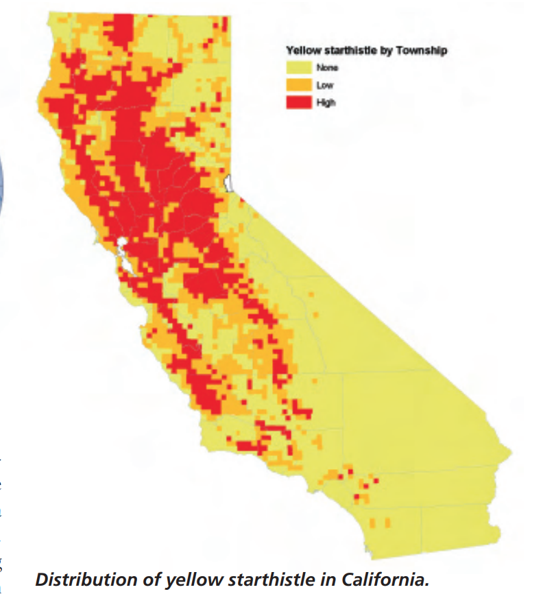
Non-native yellow starthistle is a noxious weed with thorny spines that is poisonous to horses and may damage the eyes of grazing livestock. In California, it can grow to shoulder height, forming massive, thorny patches that can block popular trails. The BLM Mother Lode Field Office uses herbicides, targeted sheep grazing, mowing, mechanical removal and controlled burns to fight yellow starthistle and other invasive weeds at Magnolia and Cronan ranches. However, with roughly half of the 735-acre Magnolia Ranch infested with yellow starthistle, BLM staff are turning to other environmentally responsible remedies.  

In 2019, the yellow starthistle rosette weevil was approved for release to help reduce densities of yellow starthistle in the western U.S. The weevil originated in the Mediterranean region and evolved to specifically eat yellow starthistle.  

The weevils are a cost-effective control method because they are less labor intensive and can treat large infestations of weeds that are difficult to access. They also are a safe option because they do not attack crops or native plants. The USDA Agricultural Research Service (ARS) in Albany, California provided the plant-eating weevils for the Magnolia Ranch release. Once the weevils are established, it is hoped they will reproduce and expand their range in the coming years.   

“These weevils will complement the insects that state and federal partners have previously released in the Pacific west to attack the flowerheads and reduce the seed production of yellow starthistle,” said ARS Entomologist Dr. Lincoln Smith. “It will take several years to see results, since the weevils only have one generation per year. But once established, the populations will grow exponentially.” 
Any good experiment needs a catalyst, and that was provided by the UC Cooperative Extension Service. It was their networking and on-the-ground work that brought the BLM and ARS together to arrange the Magnolia Ranch weevil release.  

“One of the Cooperative Extension Service’s main purposes is to bring the latest research together in the communities where we work,” said UC Cooperative Extension Farm Advisor Scott Oneto. “Yellow starthistle impacts nearly 15 million acres throughout California and causes significant losses to ranchers and land managers alike.” 

Now, the partners will be watching and waiting, instituting an intensive monitoring schedule, measuring vegetation, and pulling up plants to see if the insects are effectively boring holes in the starthistle roots and flowers. The recreating public will not notice any effects, but the BLM will avoid using herbicide application, grazing or prescribed fire which could harm the weevils near the release site.  

The BLM is committed to keeping public landscapes healthy and productive. If monitoring shows the weevils are successful at reducing yellow starthistle, the Mother Lode Field Office plans to release more rosette weevils at nearby Cronan Ranch in the future.  
​

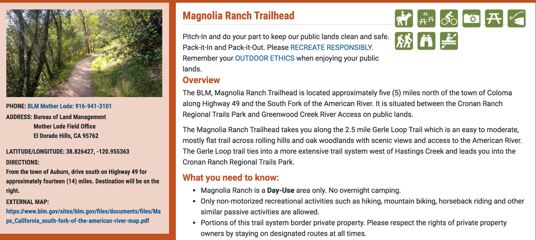
Magnolia Ranch is located along the South Fork of the American River. Opportunities include white-water rafting, kayaking, picnicking, hiking, horseback riding, bicycling, hunting, fishing, gold panning and wildlife viewing. For more information visit www.blm.gov/visit/magnolia-ranch-trailhead or call the Mother Lode Field Office at 916-941-3101. 

To read the original article, CLICK HERE to see YubaNet.com 

Picture
Picture

Lupine super bloom at Folsom Lake SRA, enjoy it now!

4/25/2021

 
Picture
About every four years, the lupines put on an incredible show along the Folsom Lake shore, and this is one of those years. Be sure to hike or ride your horse on the beach trail before the flowers disappear. This photo is of the Folsom Lake SRA Mounted Patrol members enjoying the flowers.

The beach trail is not maintained, but randomly exposed when the lake level is low and can be accessed in a few places. It's below the Pioneer Express Trail (no bikes on that trail, and the beach trail sand is too deep for bikes.)

Walking or riding through these flowers is a total sensory immersion experience - the color, the wonderful smell, hearing the bees. It's unforgettable.

​Enjoy!

Plan Ahead Campsites and Trailheads: What to Expect in 2021 When Visiting the Eldorado National Forest

4/24/2021

 
Picture
Placerville, CA…The Eldorado National Forest is busy getting ready for the upcoming visitor season. Exciting upgrades to many developed recreation sites are underway or have been recently completed by our partners Sacramento Municipal Utility District (SMUD) and El Dorado Irrigation District (EID). These companies manage reservoirs and support recreation facilities throughout the forest which are part of their licensed hydroelectric power generation projects. These projects provide water storage, renewable energy and a vast number of recreational opportunities. Many of these recreation facilities are operated by another partner, Royal Elk Park Management (REPM), a forest concessionaire that oversees and maintains multiple sites under a Special Use Permit. As you can see, along with forest recreation staff, there is a large team working to make your visit safe and enjoyable! Recreation site closures while improvements are being made, changes in user fees, and updates to the reservation system are important things visitors should know prior to their visit in 2021.  

RENOVATION UPDATES
CG = Campground / DU = Day Use / TH = Trailhead
Closures for reconstruction / improvements – Seek an alternative location while renovations are in progress
·      Yellowjacket CG & Boat Launch (all Year)
·      West Point CG including access road from North Union-Valley Rd (all year)
·      West Point Boat Ramp & parking area from NUVR (after Labor Day)
·      Sunset Boat Ramp (after Labor Day)
·      Wolf Creek Group Campground & access Road (all year)
·      Wolf Creek CG from NUVR (after Labor Day)
·      Camino Cove CG from NUVR (all year)
·      Dru Barner CG/DU (partial closures in 2021)

Upgrades completed – Enjoy these new and improved facilities
·      Caples Lake CG
·      Silver Lake East CG (additional improvements planned late 2021/2022)
·      Buck Island Toilet Installation
·      East Slab Creek Hand-launch Boat Access/DU
·      West Slab Creek Whitewater Boating Access/DU
·      Brush Creek Reservoir Boat Ramp/DU
·      Northshore RV CG
·      Loon Lake Boat Ramp/DU/TH

Automated Fee Machines are installed at the following locations – Fees can be paid with credit / debit cards for convenience
·      Pyramid Creek TH/DU
·      Pipi CG/DU
·      Pardoes Point CG/DU
·      Wrights Lake CG/DU
·      Icehouse Boat Ramp/DU/CG
·      Sunset Boat Ramp/DU/CG
·      Wench Creek CG
·      Yellowjacket Boat Ramp/DU/CG
·      Loon Lake CG/Boat Ramp/DU
·      New additions for 2021:
·     Silver Lake CG
·     Carson Pass TH

Recreation.gov – Reservation System Updates
·      Sunset-Union Valley has all the First Come First Serve sites listed in their system now
·      New facilities added to the reservation system in 2021:
·      Dru Barner CG, Northshore CG and Wench Creek CG
·      Adventure Mountain self-contained RV campsites

FEE UPDATES
REPM Operated Sites Fee Leveling / Increase – Maintenance costs vary with distance to services and fees are being made consistent across the forest

·      Day Use Sites – $10
·      Standard sites WITH water- $28
·      Standard sites WITHOUT water- $25
·      Group sites have an adjusted value based on amenities and location – see recreation guide for details


Day Use Fee Waived for 2021 at Several Locations
Wrights Lake Day Use and Trailheads and Kirkwood Lake Day Use will be fee free in 2021 to provide an opportunity for additional public input on the new fees at these sites. The REPM concessionaire fee structure has been modified with these changes:
·      Wrights Lake Day Use – No fees in 2021
·      Rockbound Trailhead – No fees in 2021
·      Twin Lakes Trailhead – No fees in 2021
·      Kirkwood Lake Day Use – No fees in 2021

Our complete 2021 fee schedule can be found online here.


CHECK FOR ONGOING UPDATES
Check the forest website at www.fs.usda.gov/eldorado or call the ranger stations for current information on season opening dates for our facilities. Our virtual offices are staffed to provide visitor information from 8:00 am to 4:30 pm, Monday through Friday: 
·      Forest Supervisor’s Office – 530-303-2412
·      Georgetown Ranger District – 530-334-6477
·      Placerville/Pacific Ranger District – 916-500-4712
·      Amador Ranger District – 209-259-3774

The forest will also be publishing several articles in the coming weeks with important information and updates on recreation operations for 2021. 

OUTDOOR SAFETY IN THE COVID ENVIRONMENT
We are continuing to adhere to COVID safe practices. To support a safe and enjoyable experience for all, the Forest Service encourages visitors to wear a mask on National Forest System (NFS) lands where physical distancing cannot be maintained and, when an individual is likely to interact with others outside their household. These areas include but are not limited to, high-density developed recreation sites, congested trailheads, along popular hiking paths, and around visitor information boards, parking areas and shelters.

It is recommended that a mask that aligns with CDC guidance be carried at all times by everyone over the age of 2 who visits NFS lands, regardless of the purpose.


RECREATE RESPONSIBLY
As always, please recreate responsibly on your National Forests by packing out your trash and not damaging natural or cultural resources. Tread lightly and leave no trace! 
###
The U.S.D.A Forest Service is an equal opportunity employer. The mission of the Forest Service is to sustain the health, diversity, and productivity of the nation’s forests and grasslands to meet the needs of present and future generations.

California Conservation of Trails water trough filled and ready for summer at Granite Bay Equestrian Staging

4/22/2021

 
Picture
Picture
The nonprofit 501c3 California Conservation of Trails, the fund raising arm of the Folsom Lake SRA Mounted Patrol helped fund and design this beautiful horse trough, adorned with commemorative rocks. Individuals donated funds for this project through the California Conservation of Trails. The black holding tank was donated by Douglas Pet Supply.

This beautiful and useful horse trough was installed by Paul Bruhn over a few days in January 2020.

​On the hot days of summer, as horses come in to the staging area from walking the trails, this lovely water trough is waiting for them.

If anyone wishes to donate for future projects to the California Conservation of Trails,

California Conservation of Trails
P.O. Box 2278
Granite Bay, California 95746


Click HERE to email California Conservation of Trails.

Click HERE to visit the California Conservation of Trails website.


Local wildflower guide from Placer Land Trust

4/15/2021

 
Picture


This PLT Wildflower Guide is specific to the Canyon View Preserve, but these flowers grow in almost all our public lands in this area this time of year. You can click to download the two page Guide here.
​


Picture

Woods Riders and Gold Country Trails Council's big rides in Tahoe NF are cancelled because of COVID restrictions in Nevada County

4/14/2021

 
Picture
This update from the President of Gold Country Trails Council, Bernie Molloy:

"Sadly, the GCTC board received information that last night caused us to vote to cancel the June 5, 2021 Poker Ride at Skillman Horse Camp for this year. Because we are still in the restrictive Red Tier, Nevada County is still only allowing 50 people at outdoor gatherings. Because of this, USFS will not issue us a permit for an event with more than 50 people. They will only permit for future events, based on current restrictions.

The Woods Riders were gearing up for their May 22nd Skillman event, which is nearly identical in scope and size to our Poker Ride. The USFS declined to issue them a permit based on the COVID restrictions now in effect. Woods Riders have decided to cancel their event. They, like us, can not plan and implement a complex plan on short notice, should the regulations loosen at a later time.
The GCTC Annual Poker Ride has always been our premier event, and we do not want to damage the ride's reputation by having a last minute event that will not meet GCTC's high standards.

Bernard Molloy, President
Gold Country Trails Council"

​

Rattlesnakes are coming out

4/12/2021

 
Picture
Rattlesnakes are coming out of their dens, basking in the sun, and becoming more active. Today two were spotted on Olmstead Loop, and another on the paved road there.

Keep an eye out on the trails, especially at Cronan Ranch, Folsom Lake, Auburn SRA. In our area, rattlesnakes bite hikers, runners, dogs and horses every year, usually starting in April.


 -  Keep your dogs ON LEASH so they don't get bitten. Rattlesnake avoidance training is available all year round. See trainers online, such as "Get Rattled."
 -  Many horses will alert you to snakes - Equestrians should really listen to their horses who can hear and smell them way before their riders can.
 -  Wear long loose pants and high boots.
 -  STAY on the trails. It's almost impossible to see the snakes in high grass.
 - Mt. bikers slow down so you don't run over them (and get bit in the process).


SNAKE FACTS
Most people bitten by rattlesnakes have inadvertently stepped or ridden over them. Snakes detect movement by sensing vibrations in the ground. Their eyes see well even in low light. Rattlesnake bites can be dangerous but are very rarely fatal to humans. With proper medical treatment, including antivenin, bites are usually not serious. Rattlesnakes can strike 2/3rds their length, and they are wonderfully camouflaged in the same color grass.


NOT ALL RATTLE
Young rattlesnakes do not yet have their rattles, though they are as dangerous as adults, according to the National Park Service at Yosemite. Furthermore, some adults may lose their rattles, so it is a good idea look out for the triangular head.
After the rattle, rattlesnakes’ most distinctive physical feature is their triangular head. Also, they have vertical pupils, like cat’s eyes. (In Folsom Lake, rattlesnakes that rattle get killed, those that don't...don't. Meaning that after several generations, we have many families of silent snakes.)

RATTLESNAKES ARE LOCAL
Generation after generation of rattlesnake will use the same dens, sometimes the same den for more than 100 years. Upon leaving their dens, they like to sun themselves on rocks and other open places. Though they are not nocturnal, in the hot summer months they may be more active at night.
​
CALIFORNIA KING SNAKES ARE GOOD SNAKES!
Despite their venom, rattlesnakes are no match for California King snakes, which are fond of putting them on their dinner menus. DON'T KILL CALIFORNIA KING SNAKES! (pictures below)


Picture
Picture

‘Beautiful timing’: Volunteers prepare Daspah Seyo Trail in Grass Valley for public premiere

4/10/2021

 
Picture
New rustic thoroughfares have been added along Wolf Creek through the combined efforts of the city of Grass Valley, Bear Yuba Land Trust, Wolf Creek Community Alliance and the Nevada City Rancheria.

Locals and visitors alike can participate this month in the land trust’s inaugural NatureFest, a free event dedicated to engaging families in the outdoors.

The Daspah Seyo Trail, named in honor of the Nisenan people, offers the option to get closer to the water along Wolf Creek.

Land trust Trails Coordinator Bill Haire said the paved Wolf Creek Trail, which begins near the wastewater treatment plant, was just opened before the COVID-19 pandemic hit last spring.
“It was just beautiful timing because since that it’s been a place for people to get outdoors and walk and exercise and feel safe and all that,” Haire said.

Haire said the paved project improves everyone’s access to nature, including those who use wheels out of choice or necessity. “That option is excellent for anyone with any disabilities or those pushing a stroller,” Haire said. “This gives people the option of leaving paved trails for dirt trails.”

Haire said because the paved trail is somewhat distant from the creek itself, the land trust approached the city of Grass Valley to ask if it could build a more primitive trail — narrower, rougher — closer to the water’s edge.

“We know how humans behave,” Haire explained. “They’re going to go down to the water and rather than have them make their own trails, let’s make one that takes them down a reasonable path — a sustainable trail.” Haire said city readily approved the idea.
​
The “woodsy” trail, set to premiere April 24, was created by volunteers.
“The city funded the oversight that the BYLT is doing,” Haire said, referring to project oversight and volunteer management.
Haire said his team is wrapping up work on the southern end of the trail as it leaves city and Wolf Creek Lodge property.

“’Daspah’ is the name of Grass Valley, and the people here called themselves ’Daspia,’” said Shelly Covert, spokesperson for the Nevada City Rancheria and executive director of the California Heritage Indigenous Research Project. Covert said “seyo” can refer to any type of waterway. Covert said the Wolf Creek Community Alliance’s decision to name the trail in honor of the Nisenan follows a positive trend in her tribe’s visibility. “People are now curious and are asking,” Covert said. “The really unfortunate piece is much of that knowledge is lost.” Covert said she feels a sense of shame when she can’t answer what her people’s ancestors named certain local spots, but feels empowered and creative when asked for input on nomenclature. Covert said her community has received such little attention over the years that naming a trail inspires gratitude even amid the tribe’s current fight for formal recognition. “There’s been nothing for so long,” Covert said. “They’re like, ’you got a trail with a Nisenan word in it?’ and they’re so happy.”

Josie Crawford, executive director of the Wolf Creek Community Alliance, said her organization is working with Covert to identify and plant botanicals used by the Nisenan people in a shaded patch of grass 100 yards below the wastewater treatment plant along the new dirt trail. Crawford said the alliance is working with a landscape designer to plant the first iteration of the native plant garden before fall 2021. Crawford said she hopes the flowers will both beautify and edify the surrounding area.

Participants in the first annual NatureFest can go to Alan Thiesen Trail at Adam Ryan Wildlife Preserve in Alta Sierra; the Wolf Creek Trail; the Litton Trail near Sierra College; or Banner Mountain’s Cascade Canal Trail on April 24 to explore the region’s flora and fauna.

“When you do get down in there you’re pretty much in a different world,“ Haire said of the Daspah Seyo Trail, adding ”even though there’s a shopping center within a quarter of a mile.“

CLICK HERE to see many more photos and the complete article in The Union newspaper.

​

Class 1 electric motor bikes now allowed on some trails in Tahoe National Forest*

4/9/2021

 
Picture
By Kelsey Marier - Published: Apr. 8, 2021 at 10:35 PM PDT
TRUCKEE, Calif. (KOLO) - For the first time, a new class of electric bicycles is allowed on 35 miles of trails in the Tahoe National Forest. This shift means a new experience is waiting for you and your family.

"I see E-bike use continuing to grow in the region." said Jonathan Cook-Fisher, District Ranger in Truckee Ranger District
Forest officials have opened up 35 miles of existing non-motorized trails to class 1 E-bikes in and near Truckee. It's the first national forest in the Pacific Southwest region to allow these types of bikes on its trails. They were not allowed before because they were put in the same class as motorized vehicles.
"They are particularly popular with families, or with individuals who are maybe reengaging with mountain biking, perhaps recovering from knee surgery, or lost that ability to really get out deeper into the trails and explore the forest," Jonathan Cook-Fisher, District Ranger in the Truckee Ranger District said.

So what is an E-bike?
"it provides a power-assist that's most useful on flat or uphill terrain. You have to be pedaling for that motor to be engaged and it does shut off at 20 miles an hour, Cook-Fisher said. Class 2 E-bikes have a throttle and max assisted speed of 20 mph. Class 3 E-bikes are pedal-assisted only, with a max assisted speed of 28 mph. According to Cook-Fisher, class 1's have most of the same components as a traditional mountain bike and are safe when it comes to speed.

Cook-Fisher added, "The class 1 E-bike is very quiet, you may not even notice that the person who just rode by you is on a class 1 E-bike. A standard mountain bike rider going downhill was actually able to achieve higher speeds than a class 1."
(MLT: This statement is disputed and speed depend on the trails traveled.  Basic physics would tell us since the e-bikes are considerably heavier, they can achieve higher speeds going downhill. Because they have a motor, they can travel much faster and farther uphill than standard mt. bikes.)


Class 1 E-bikers can now ride on the Emigrant Trail, Big Chief Trail, and Sawtooth Trail. Cook-Fisher says this mode of transportation won't leave a negative imprint on our planet and provides inclusive access to what the Tahoe National Forest has to offer.
(MLT: This statement is disputed by environmental, hikers and equestrian groups. Tahoe National Forest has been sued by several groups for adding motorized e-bikes on non-motorized trails without proper science and process.)

"The environmental impacts from E-bikes are indistinguishable from standard mountain bikes," Cook-Fisher said. 
(MLT: This statement is disputed by environmental, hikers and equestrian groups. Tahoe National Forest has been sued by several groups for adding motorized e-bikes on non-motorized trails without proper science and process.)

In addition to the 35 miles of non-motorized trails in the Tahoe National Forest, the Town of Truckee allows all three classes of E-bikes on 22 miles of scenic paved paths, bringing the total to 57 miles of paved and dirt trails open for riding. To view a map of the multi-use paved trails and bike paths, click here. 

CLICK HERE to see the article and view the television news on KOLO-TV


E-bikes are surging in popularity. What does that mean for Tahoe trails?

4/7/2021

 
Picture
A proposal to allow certain electronic bikes access to nearly 150 miles of trails in the Tahoe-area basin is a step in the right direction but still has a long way to go, according to area riders.
The U.S. Forest Service’s Lake Tahoe Basin Management Unit allows certain classes of e-bikes on 25 of its 385 miles of trails.

​Under the management unit’s proposed plan, an additional 120 miles of new and existing trails would open to e-bikes, bringing the total number of e-bike accessible miles to 145, not counting dirt roads.

“This project is our effort at being proactive and managing e-bikes,” according to Jacob Quinn, engineering technician for the LTMBU. “We’re not trying to only open difficult and longer trails, but a variety.”

But Collins said the forest service is a little behind the ball and keeping e-bikes off non-designated trails will be a challenge.

​One reason e-bikes are being pushed onto public trails - money:
"The first year, e-bikes accounted for 1 percent of dollar sales at the shop. But by the third year, they accounted for 5 percent of dollar sales; by the fifth year, they accounted for 35 percent; and last year, they accounted for 75 percent of total dollar sales at College Cyclery.  (An entry-level mountain e-bike is about $5,500...)"

But “the general sentiment with e-bikes is pretty polarized,” according to Amanda Wentz, a board member with the Biggest Little Trail Stewardship, a nonprofit group that builds and maintains trails throughout the Reno area. “From a management perspective, it makes sense why they are so tricky – it’s a grey area.”

The Lake Tahoe Basin Management Unit spans Alpine, El Dorado and Placer counties in California, plus Douglas and Washoe counties and Carson City in Nevada.
Nevada has not adopted a tiered e-bike classification system, but California has, depending on the speed the bike can travel and how much assistance riders must provide the vehicle.
  • A class 1 e-bike is equipped with a motor that assists the rider when he/she is pedaling and stops assisting when the bicycle reaches the speed of 20 miles per hour. This is the only class of e-bike the LTBMU is considering allowing on trails.
  • A class 2 e-bike is equipped with a motor that may be used exclusively to propel the bicycle and stops assisting when the bicycle reaches the speed of 20 miles per hour.
  • A class 3 e-bike is equipped with a speedometer and a motor that assists only when the rider is pedaling and ceases to assist when the bicycle reaches the speed of 28 miles per hour.
For comparison, Google Maps uses an average speed of 10 mph for bicycle directions and the average person typically cycles at about 13 mph, according to the Rails to Trails Conservancy, a nonprofit group that converts old railroad grades to multi-user trails. The average speed of a Tour de France bicycle racer is 25 mph.
Wentz, who has only ridden an e-bike for a few weeks, said she hears many misconceptions about them, such as the bikes chewing up trails.“There’s just not enough power with an e-bike to actually do that,” she said. “I think there’s misconceptions about the amount of damage they can do.”
According to the Rails to Trails Conservancy, “User conflicts caused by speed are more about behavior than technology. Both traditional cyclists – especially fit cyclists or racers – and e-bike users have the potential to cause speed-related user conflicts.”
“From a trail-builder standpoint, between a regular and class one e-bike, there’s really no difference in wear on the trail. It’s just a philosophical problem that needs to be resolved,” said Randy Collins, owner of College Cyclery in Reno.
Wentz has also observed traditional riders exhibit jealousy toward e-bike riders who are ascending hills faster without working as hard and possessiveness over area trails.
“I think of it differently,” she said. “Great. Let’s get people on more trails, and then let’s get more trails.”
Under the proposed plan, new and enhanced trailheads including Elks Point and Pine Drop Trailhead in the Kings Beach area will be open to e-bikes, as would the Incline Flume, the Angora Ridge trail system and a new trail to be built in the Emerald Bay area.
No trails that access the Desolation Wilderness will be open to e-bikes, nor will the Tahoe Rim Trail.
South Lake Tahoe’s Pope Baldwin Bike Path, the highest-use trail in the Tahoe Basin, will also remain closed to e-bikes.
“On a summer weekend, there will be thousands of users on it every day. You’ll see hikers, runners, road bikers, people riding beach cruisers, people pushing strollers, everybody uses that trail in the summer. Our intent was to not introduce another use to a trail that is already at capacity,” Quinn said.

When Collins started selling e-bikes seven years ago, he didn’t know what to expect.  
The first year, e-bikes accounted for 1 percent of dollar sales at the shop. But by the third year, they accounted for 5 percent of dollar sales; by the fifth year, they accounted for 35 percent; and last year, they accounted for 75 percent of total dollar sales at College Cyclery.
An entry-level mountain e-bike is about $5,500, about the equivalent price of a good mountain bike without a motor, Collins said.
Collins switched to riding an e-bike several years ago. It’s now his only bike. “That’s what people generally find when they get an e-bike,” he said. “The old bike becomes an obsolete item.” Collins said more than half of his sales are to regular customers. “Demand is so high with e-bikes,” he said. “When you ride them, your enjoyment factor doubles. It’s intangible. Once you do it, you’ll never go back.”

A decision on the proposed Tahoe-area e-bike plan should be made by the end of the year, Quinn said.
But Collins said the forest service is a little behind the ball and keeping e-bikes off non-designated trails will be a challenge.
“The train left the station a couple years ago. You have to get ahead of this,” he said. “They are making moves to accommodate e-bikes, but they are on trails everywhere right now. They don’t have a way to enforce it.
“I don’t think it will make much difference because people are using them now. But from a legal standpoint, it’s a great move forward.”
Wentz said she supports the Forest Service’s efforts to catch up to e-bike usage on trails.
“I think that e-bikes are only going to increase in popularity, and just mountain biking in general. And if we can all figure out how to play along and play together, that’s pretty good.”
CLICK HERE to see the original article and photos in the Reno Gazette Journal newspaper.
​

    Archives

    March 2023
    February 2023
    January 2023
    December 2022
    November 2022
    October 2022
    September 2022
    August 2022
    July 2022
    June 2022
    May 2022
    April 2022
    March 2022
    February 2022
    January 2022
    December 2021
    November 2021
    October 2021
    September 2021
    August 2021
    July 2021
    June 2021
    May 2021
    April 2021
    March 2021
    February 2021
    January 2021
    December 2020
    November 2020
    October 2020
    September 2020
    August 2020
    July 2020
    June 2020
    May 2020
    April 2020
    March 2020
    February 2020
    January 2020
    December 2019
    November 2019
    October 2019
    September 2019
    August 2019
    July 2019
    June 2019
    May 2019
    April 2019
    March 2019
    February 2019
    January 2019
    December 2018
    November 2018
    October 2018
    September 2018
    August 2018
    July 2018
    June 2018
    May 2018
    April 2018
    March 2018
    February 2018
    January 2018
    December 2017
    November 2017
    October 2017
    September 2017
    August 2017
    July 2017
    June 2017
    May 2017
    April 2017
    March 2017
    February 2017
    January 2017
    December 2016
    November 2016
    October 2016
    September 2016
    August 2016
    July 2016
    June 2016
    May 2016
    April 2016
    March 2016
    February 2016
    January 2016
    December 2015
    November 2015
    October 2015
    September 2015
    August 2015
    July 2015

    Categories

    All

    RSS Feed

Home
Contact
 Mother Lode Trails is YOUR local volunteer-run trail information and resource website. Here you can find
up-to-the minute information on trail alerts, links and trail news for Placer,  Yuba, and Nevada counties.
Mother Lode Trails is trademarked.