U.S. Forest Service- Tahoe National Forest
Campgrounds update for Tahoe National Forest, May 28-June 4
The following campgrounds opened Friday, May 22, 2020
• Highway 89, South
o Goose Meadow Campground
o Granite Flat Campground
• Foresthill Divide Road
o Giant Gap Campground
o Shirttail Campground
• Marysville Road
o Dark Day Campground (no group sites)
o Garden Point Campground (boat in)
o Madrone Cove Campground (boat in)
o Schoolhouse Campground
The following campgrounds are closed for the upcoming weekend, May 29-31, 2020. Closing any site for any reason is not an action we take lightly, but protecting our visitors and employees remains our highest priority. We are working with our state and local partners to determine the best path forward to safely reopen all campgrounds.
Reservation cancellations vary for individual campgrounds. Please see the list below for specific reservation information.
Reservations have been canceled through May 31 for the following campgrounds:
• Interstate 80
o Hampshire Rocks
o North Fork
• Foresthill Divide Road
o Ahart
o French Meadows
o Lewis
Reservations have been temporarily canceled for these campgrounds through June 5. If these campgrounds open before June 5, your reservation will be honored and camping will be available. If these campgrounds do not open before your reservation date, you will be refunded. Please check back in for weekly campground opening updates.
• Boca Stampede Road
o Boca
o Boca Rest
o Boca Springs
o Boyington Mill
o Logger
• Highway 89, North
o Cold Creek
o Lakeside
o Lower Little Truckee
o Prosser Family
o Upper Little Truckee
Reservations have been temporarily canceled for these campgrounds through June 18. If these campgrounds opens before June 18, your reservation will be honored and camping will be available. If these campgrounds do not open before your reservation date, you will be refunded. Please check back in for weekly campground opening updates.
• Interstate 80
o Indian Springs
• Gold Lake Road
o Berger
o Diablo
o Packsaddle
o Salmon Creek
o Sardine
• Highway 20
o White Cloud
• Highway 49
o Cal Ida
o Carlton Flat
o Chapman Creek
o Fiddle Creek
o Indian Valley
o Loganville
o Ramshorn
o Rocky Rest
o Sierra
o Union Flat
o Wild Plum
• Marysville Road
o Frenchy Point
All group campground reservations have been canceled through June 30, this includes:
o Bear Valley
o Big Bend
o Cottonwood Creek
o Coyote
o Emigrant Gap
o Gates
o Hornswoggle
o Prosser Ranch
o Skillman
o Tunnel Mils
Reservations are not available for the following campgrounds and they are currently closed:
o Grouse Ridge
o Lake of the Woods
o Mumford Bar
o Onion Valley
o Parker Flat
o Poppy
o Robinson Flat
o Sagehen Creek
o Snag Lake
o Talbot
o White Rock Lake
o Woodchuck
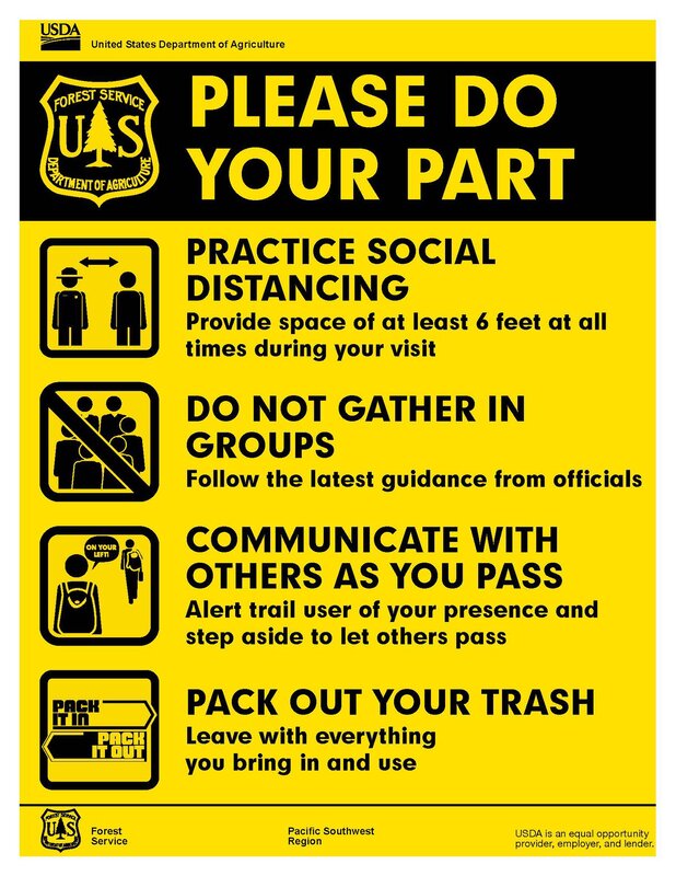
We continue to recommend that you recreate locally. All visitors should practice self-sufficiency during your visits to national forests. Recreating responsibly will help ensure that expanded access to recreational facilities, services, and opportunities continues. Responsible recreation practices should be maintained at all times, including:
• Maintaining at least six feet distancing from others
• Do not gather in groups and please follow the latest guidance from officials
• Communicate with others as you pass. Alert trail users of your presence and step aside to let others pass
• Pack out your trash and leave with everything you bring in and use.
• All services may not be available, so please plan accordingly.
The Tahoe National Forest will continue to phase in opening of facilities and services as county policies and facility preparations allow.
Campgrounds update for Tahoe National Forest, May 28-June 4
The following campgrounds opened Friday, May 22, 2020
• Highway 89, South
o Goose Meadow Campground
o Granite Flat Campground
• Foresthill Divide Road
o Giant Gap Campground
o Shirttail Campground
• Marysville Road
o Dark Day Campground (no group sites)
o Garden Point Campground (boat in)
o Madrone Cove Campground (boat in)
o Schoolhouse Campground
The following campgrounds are closed for the upcoming weekend, May 29-31, 2020. Closing any site for any reason is not an action we take lightly, but protecting our visitors and employees remains our highest priority. We are working with our state and local partners to determine the best path forward to safely reopen all campgrounds.
Reservation cancellations vary for individual campgrounds. Please see the list below for specific reservation information.
Reservations have been canceled through May 31 for the following campgrounds:
• Interstate 80
o Hampshire Rocks
o North Fork
• Foresthill Divide Road
o Ahart
o French Meadows
o Lewis
Reservations have been temporarily canceled for these campgrounds through June 5. If these campgrounds open before June 5, your reservation will be honored and camping will be available. If these campgrounds do not open before your reservation date, you will be refunded. Please check back in for weekly campground opening updates.
• Boca Stampede Road
o Boca
o Boca Rest
o Boca Springs
o Boyington Mill
o Logger
• Highway 89, North
o Cold Creek
o Lakeside
o Lower Little Truckee
o Prosser Family
o Upper Little Truckee
Reservations have been temporarily canceled for these campgrounds through June 18. If these campgrounds opens before June 18, your reservation will be honored and camping will be available. If these campgrounds do not open before your reservation date, you will be refunded. Please check back in for weekly campground opening updates.
• Interstate 80
o Indian Springs
• Gold Lake Road
o Berger
o Diablo
o Packsaddle
o Salmon Creek
o Sardine
• Highway 20
o White Cloud
• Highway 49
o Cal Ida
o Carlton Flat
o Chapman Creek
o Fiddle Creek
o Indian Valley
o Loganville
o Ramshorn
o Rocky Rest
o Sierra
o Union Flat
o Wild Plum
• Marysville Road
o Frenchy Point
All group campground reservations have been canceled through June 30, this includes:
o Bear Valley
o Big Bend
o Cottonwood Creek
o Coyote
o Emigrant Gap
o Gates
o Hornswoggle
o Prosser Ranch
o Skillman
o Tunnel Mils
Reservations are not available for the following campgrounds and they are currently closed:
o Grouse Ridge
o Lake of the Woods
o Mumford Bar
o Onion Valley
o Parker Flat
o Poppy
o Robinson Flat
o Sagehen Creek
o Snag Lake
o Talbot
o White Rock Lake
o Woodchuck
We continue to recommend that you recreate locally. All visitors should practice self-sufficiency during your visits to national forests. Recreating responsibly will help ensure that expanded access to recreational facilities, services, and opportunities continues. Responsible recreation practices should be maintained at all times, including:
• Maintaining at least six feet distancing from others
• Do not gather in groups and please follow the latest guidance from officials
• Communicate with others as you pass. Alert trail users of your presence and step aside to let others pass
• Pack out your trash and leave with everything you bring in and use.
• All services may not be available, so please plan accordingly.
The Tahoe National Forest will continue to phase in opening of facilities and services as county policies and facility preparations allow.
 RSS Feed