MOTHER LODE TRAILS
  • Home
  • About
  • Contact
  • Volunteer
  • Links
    • Law Enforcement Emergency
    • Federal, State, County Districts Parks & Trails
    • Running Clubs
    • Equestrian Clubs
    • Mt. Bike Clubs
    • Hiking Clubs
    • Trail Advocacy Organizations
    • Phone Numbers State & Federal Parks, Trails & Lands
    • Where to Eat on the Trails
  • News
  • Alerts

Impassable tree on the Cal Loop - Dardanelles Creek

7/27/2019

 
Picture
Report from the Tevis Cup 100 Mile One Day Ride - Western States Trail Foundation: 
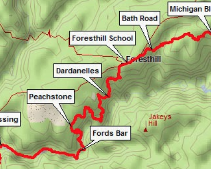
​An impassable tree has been reported down near Dardanelles creek so if planning to ride on Cal Loop this weekend you will need to choose another route or plan on turning around at this spot. Trail maintenance crews will advise as soon as it’s cleared. Thank you!  - WSTF Trails Team

Tahoe National Forest changes policy on E-bikes and adds them on some non-motorized trails

7/24/2019

 
Picture
Three years ago the USFS officially decided to manage e-bikes as motorized vehicles on Forest Service land, which effectively shut eMTBs (bikes with electric motors) out of non-motorized trails. However, the USFS recently decided to allow Class 1 e-bike usage at Mammoth Mountain in California on land the USFS leases to the resort. And now Tahoe National Forest is following their lead.

The Tahoe National Forest is quick to state that they haven’t made a “decision” or “changed their policy” on electric bikes within the forest service unit. With that said, electric mountain bikers now have a recommended list of trails to ride within the Tahoe Nat’l Forest as of last month. A PDF on the website dated June 24, 2019 lists 32 trails on five different networks that are now eMTB-accessible, ranging in both difficulty and terrain. The list of trails that allow Class 1 e-bikes includes favorites like the Pioneer Trail,  Hole in the Ground and Bullards, among others.

Allowing eMTBs on select non-motorized trails within the Tahoe National Forest is notable in light of a 2015 USFS briefing paper stating that e-bikes are considered “motor vehicles” and subject to Travel Management Plan restrictions.

Public Affairs Officer Joe Flannery elaborated on the “non-change in policy. There really was no decision, and I’m saying decision with a capital D,” says Flannery. For official policy changes within the National Forest, the Forest Service must follow the National Environmental Policy Act (NEPA) and conduct environmental impact statements or assessments.
“We didn’t trigger NEPA and NEPA didn’t need to be triggered.”
(Mother Lode Trails disagrees with Mr. Flannery. Adding USFS-designated motorized vehicles to non-motorized trails is a trail policy change and should trigger NEPA and their oversight.)

But, the Lake Tahoe Basin Management Unit (LTBMU) which surrounds the perimeter of the lake holds the stance that eMTBs “are motorized vehicles. Use of motor-assisted bicycles is only allowed on motorized trails.”

Other states are passing their own laws
Earlier this year in the states of Colorado and Washington e-bike usage was discussed in new trails plans. In Colorado, land managers seem split on whether the new law opens trails to eMTBs. In Washington, the law more clearly prohibits e-bike access on natural surface trails.

For the original article, CLICK HERE in Singletracks magazine.

If you would like to call or comment on this change of trail usage:
Tahoe National Forest
631 Coyote Street
Nevada City, CA 95959
Supervisors Office (530) 265-4531

TNF Trails Manager
Paul Hart 
<pdhart@fs.fed.us>
530-478-6253 x 243

Comment and call 
​Joe Chavez, TNF Trails Program Coordinator
joetchavez@fs.fed.us
530-478-6158 


UPDATE: Bees! No, ground wasps! First reports of the season

7/21/2019

 
Picture
UPDATE JULY 20, 2019
Spenceville ground wasps at the second gate. From a reporter: Rode at Spenceville yesterday and my horse got stung by wasps on one of the gates. Didn't notice them till we got too close. I reported it to Park Watch Report and it should get to CA Fish and Game. Location: if you park at the cattle pen area, go across the street, through new little gate, turn left parallel road, then right to go to the creek. It's the second gate after the creek.


UPDATE JULY 18, 2019,  7:30PM
A reporter saw yellow jackets setting up house in the post with the sign next to the big rock a lot of the equestrians use for a mounting rock at Magnolia Ranch trailhead yesterday afternoon.

JULY 18, 2019,  10:10 AM
A reporter encountered some ground wasps yesterday on the new bridge out of the Magnolia Ranch trailhead. 

All trail users, beware! You can upset these territorial wasps by just sauntering by their ground nests. Wasps can sting repeatedly and cause serious, even life threatening, allergic reactions on people and their pets. If you encounter them, quickly (run!) leave the area they are protecting. If you would like to help reduce their populations around trails, contact the land manager and ask if you can hang and GPS wasp traps near their nests. GPS helps you remove them in the late fall.
Picture

45 day countdown begins for public response to Auburn SRA's future

7/20/2019

 
Picture
PRESS RELEASE: PRELIMINARY PLAN AND DRAFT ENVIRONMENTAL DOCUMENTS ON THE
FUTURE OF AUBURN STATE RECREATION AREA ARE NOW AVAILABLE
The Press Release is here:  <http://www.parks.ca.gov/NewsRelease/897>

You only have 45 days in which to respond. As usual, they give the public only 45 days in which to read hundreds of pages of dense documents, attend the open house to ask questions, and then compose and write a response, whereas Auburn SRA Planners have been working on this plan for over ten years. 

SEPTEMBER 3, 2019 IS THE DATE
"Written comments on the environmental documents may be submitted at the open house or emailed by close of business Tuesday, September 3, 2019, to plan.general@parks.ca.gov; regular mail to Bonnie Van Pelt, Bureau of Reclamation, 7794 Folsom Dam Road, Folsom, CA 95630; or faxed to (916) 537-7035. Hard copies of the documents can be reviewed at the Auburn SRA Sector Office, 501 El Dorado Street in Auburn."

OPEN HOUSE
California State Parks and the U.S. Bureau of Reclamation invite the public to attend its upcoming open house to get the latest update on the future of Auburn State Recreation Area (Auburn SRA). The public will be able to study exhibits, ask questions and leave written comments on the joint Auburn SRA Preliminary General Plan/Auburn Project Lands Resource Management Plan (Plan) and a Draft Environmental Impact Report/Environmental Impact Statement (EIR/EIS).
The open house will be held on:

Thursday, August 15, 2019 from 5 p.m. to 8 p.m.
Northside Elementary School Cafeteria
860 Cave Valley Road
Cool, CA 95614
No scheduled presentation
Children are welcome

CLICK HERE FOR MORE INFORMATION
<
http://www.parks.ca.gov/?page_id=24325#20190716Updates>

On this page will be the background, EIR-EIS document, and the plans.


Mountain bike Meetup rides every other Friday at Hidden Falls

7/9/2019

 
Picture
Auburn Cycling is hosting mt. bike rides every other Friday at Hidden Falls starting Friday, July 12
The ride will be about 2-3 hours and vary from week to week, the pace will be strong beginner/intermediate-i depending on the group. We will try and ride 10-15 miles depending on the group.
Please bring HELMET, bike in good working order, water, spare tube, CO2 cartridge/pump, snacks for the halfway point and anything else you might need. Look for the RED Scion in the parking lot. 
Meet in the parking lot at Hidden Falls. Any questions/problems/running behind call or text me @916-539-0386
First ride:

Friday, July 12, 2019
9:00 AM to 12:00 PM

And then, every 2 weeks on Friday
CLICK HERE to join.


BYLT and GCTC invite you to the Grand Opening of Trabucco Trail on July 20

7/3/2019

 
Picture
​Join Bear Yuba Land Trust (BYLT) for the Grand Opening of Trabucco Trail on Saturday, July 20 at 8:30am. Overlooking the confluence of the Middle and North Yuba Rivers, the Trabucco Trail is a three-quarter mile extension off of the Yuba Rim Trail that is located on Rice’s Crossing North Preserve below Bullard’s Bar Reservoir. The event begins in the morning with a trail dedication, followed by a moderate three-mile hike on the Yuba Rim and Trabucco Trail out to the scenic overlook and back. Bring a bagged lunch and everyone can meet to enjoy a picnic in the meadow.

Located along a six-mile span on both sides of the Yuba River in the counties of Yuba and Nevada, Bear Yuba Land Trust’s newest and largest property, Rice’s Crossing Preserve comprises 2,707 acres extended from New Bullard’s Bar Reservoir to the north and South Yuba River State Park and Englebright Reservoir bordering the southern end.Trabucco Trail is named for Bill and Anna Trabucco, owners of Linden Lea Ranch Conservation Easement and long time supporters of BYLT.
Designated a multi-use trail, Trabucco Trail was built with equestrian use in mind. Gold Country Trails Council has partnered with BYLT to create improved equestrian parking areas, signage and gates.
​

BYLT was awarded a grant from the California Department of Natural Resources to improve the recreation on both the north and south end of Rice’s Crossing Preserve. These improvements include over 5 miles of trails, shade ramadas with picnic tables, interpretive panels, kiosks and improved parking areas.

DIRECTIONS: From Nevada City, take Highway 49 towards Downieville, turn left on Marysville Road and cross over the Bullards Bar Dam. Rice’s Crossing Preserve is located 1.3 miles from the dam. Park in the rock quarry on the right and cross the road to the North Meadow where you will find the Yuba Rim Trailhead.

INFO: Call (530) 272-5994 x 207, email Felicia@BYLT.org or sign up at www.bylt.org

UPDATE: July 7 - "California Dirt MTB Series" Mt. Bike Race on Pioneer, Dascombe, Rock Creek areas - signs will be up

7/1/2019

 
Picture
California Dirt MTB Series and USA Cycling State MTB XC Championship Series, will be held in the Rock Creek/Lone Grave Area. This nationally sanctioned mt. bike race on July 7, 2019, will be ran on the Pioneer, Hoot, Dascomb Loop, Harmony Ridge trails, with preparation for this race the two days before. The race will be staging out of the Gold Country Equestrian Trail Head off Highway 20.
Preparation will be July 6, 2019.
Registration opens July 7 at 7:00 am, and there will be 16 races. For race times see below.There will be 8 large posters (see below) in the Rock Creek Area for our upcoming event, and at entrances for equestrian drivers pulling trailers.
This is a reminder of our upcoming event on 7/7/19 in the Rock Creek Area, and connector trails besides Pioneer Trail.
Jet Lowe
YBONC Fdn., Founder
(530)513-7852
http://ybonc.org/ 
​
If you are not a participant in this race, please don't use these trails on race day. Even though other users have access to these trails during this event, for your safety it would be a good day to hike and ride other trails.

For more information CLICK HERE.

For the Map Course CLICK HERE.


Picture
Picture

    Archives

    March 2023
    February 2023
    January 2023
    December 2022
    November 2022
    October 2022
    September 2022
    August 2022
    July 2022
    June 2022
    May 2022
    April 2022
    March 2022
    February 2022
    January 2022
    December 2021
    November 2021
    October 2021
    September 2021
    August 2021
    July 2021
    June 2021
    May 2021
    April 2021
    March 2021
    February 2021
    January 2021
    December 2020
    November 2020
    October 2020
    September 2020
    August 2020
    July 2020
    June 2020
    May 2020
    April 2020
    March 2020
    February 2020
    January 2020
    December 2019
    November 2019
    October 2019
    September 2019
    August 2019
    July 2019
    June 2019
    May 2019
    April 2019
    March 2019
    February 2019
    January 2019
    December 2018
    November 2018
    October 2018
    September 2018
    August 2018
    July 2018
    June 2018
    May 2018
    April 2018
    March 2018
    February 2018
    January 2018
    December 2017
    November 2017
    October 2017
    September 2017
    August 2017
    July 2017
    June 2017
    May 2017
    April 2017
    March 2017
    February 2017
    January 2017
    December 2016
    November 2016
    October 2016
    September 2016
    August 2016
    July 2016
    June 2016
    May 2016
    April 2016
    March 2016
    February 2016
    January 2016
    December 2015
    November 2015
    October 2015
    September 2015
    August 2015
    July 2015

    Categories

    All

    RSS Feed

Home
Contact
 Mother Lode Trails is YOUR local volunteer-run trail information and resource website. Here you can find
up-to-the minute information on trail alerts, links and trail news for Placer,  Yuba, and Nevada counties.
Mother Lode Trails is trademarked.