MOTHER LODE TRAILS
  • Home
  • About
  • Contact
  • Volunteer
  • Links
    • Law Enforcement Emergency
    • Federal, State, County Districts Parks & Trails
    • Running Clubs
    • Equestrian Clubs
    • Mt. Bike Clubs
    • Hiking Clubs
    • Trail Advocacy Organizations
    • Phone Numbers State & Federal Parks, Trails & Lands
    • Where to Eat on the Trails
  • News
  • Alerts

For the next three years, dispersed camping restrictions along HWY 20 on Tahoe National Forest lands

4/29/2022

 
Picture
NEVADA CITY, Calif. – April 29, 2022
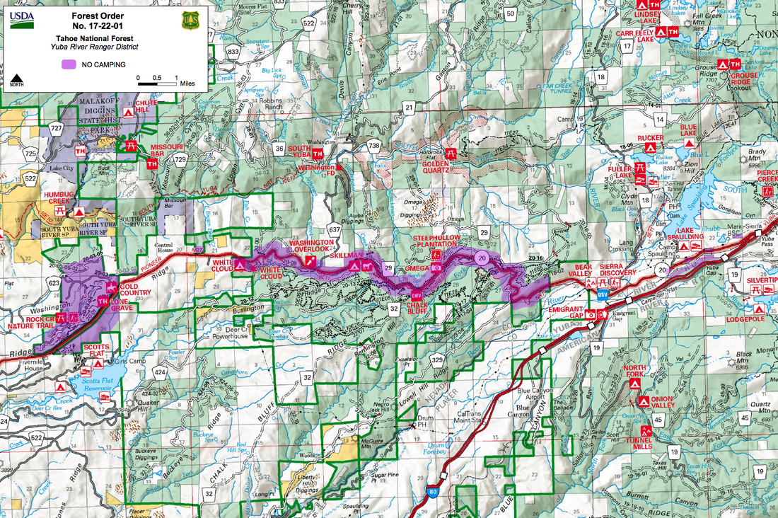
To protect natural and cultural resources, and to provide for public safety, dispersed camping will be restricted on Tahoe National Forests lands along Highway 20 from May 2nd, 2022 – May 2nd, 2025. The restrictions are for dispersed camping only and do not apply to developed campgrounds.

“The recent increase in dispersed camping along Highway 20 has created significant public safety risks, including hazardous waste that threatens human health and water quality,” said Gerald Parker, Patrol Captain on the Tahoe National Forest. “There have also been multiple instances of illegal campfires associated with dispersed camping, which increase the risk of a human-caused wildfire.”

The restrictions prohibit the following acts:
  1. Camping within 1/2 mile of the centerline of California Highway 20 between Nevada County milepost 23 and milepost 26 on lands administered by the Tahoe National Forest.
  1. Camping within 1/2 mile from the centerline of Forest Road No. 20-003 (Conservation Camp Road or Marsh Tract Road), on lands administered by the Tahoe National Forest. The Closure begins at the junction of Forest Road No. 20-003 (Conservation Camp Road or Marsh Tract Road) and California Highway 20 and continues west to the terminus of the road at the Washington Ridge Camp.
  1. Camping within 1/4 mile of the centerline of California Highway 20 between Nevada County milepost 26 and the junction of Interstate 80 on lands administered by the Tahoe National Forest.
The following persons are exempt from this Order:
  1. Any Federal, State or local officer, or member of an organization rescue or fire fighting force in the performance of an official duty.
  1. Persons with Forest Service Permit No. FS-7700-48 (Permit for Use of Roads, Trails, or Areas Restricted by Regulation or Order), specifically exempting them from this Order.
  1. Fee paying campers at the White Cloud Developed Campground or the Skillman Developed Campground while the facilities are open to the public.
A violation of these prohibitions is punishable by a fine of not more than $5,000 for an individual or $10,000 for an organization, or imprisonment for not more than six months, or both.

“Tents and vehicles in dispersed camping areas crush vegetation, compact soil, disturb wildlife, threaten sensitive cultural sites, and interfere with the use of designated trails,” said Lon Henderson, Yuba River District Ranger. “These new camping restrictions will help us protect the resources the public comes to enjoy on the Tahoe National Forest.”
​

The Forest Order and map of the areas indicated above can be viewed HERE.

https://www.fs.usda.gov/detail/tahoe/news-events/?cid=FSEPRD1016532

Sheep arrive at Cronan Ranch to reduce fire fuel load and invasive species

4/15/2022

 
Picture
  EL DORADO HILLS, Calif. – A flock of nearly 900 sheep have arrived at the Bureau of Land Management’s Cronan Ranch to start their summer of reducing wildfire threat by grazing on troublesome yellow starthistle and medusahead plants. A sheep herder will manage the flock, moving them across 1,000 acres with assistance from herding dogs and a livestock protection dog. The sheep will be removed at the end of August. “This is the seventh year that we have used sheep to control yellow starthistle and medusahead, both invasive weeds, that crowd out native plants and reduce the diversity of vegetation,” said Elizabeth Meyer-Shields, manager of the BLM Mother Lode Field Office. “Our monitoring has shown that carefully managed sheep grazing has dramatically reduced weed thatch and yellow starthistle.”  

The sheep help the Bureau of Land Management accomplish two important goals: ensure the health and safety of public lands through hazardous fuels reduction; and improve rangeland health by removing or preventing the spread of invasive plants species.

After six years of grazing, vegetation monitoring has shown a marked decrease in yellow starthistle and a notable decrease in medusahead. These invasive weeds leave behind dense patches of thatch, or dead vegetation, which can contribute to wildfire spread. Grazing has also dramatically decreased the thatch, reducing fuel loading and the risk of wildfire. In addition, native species diversity has increased, and wildflowers are blooming across the recreation area this spring, including some that have not been seen on the ranch before.

Know Before You Go:
The Cronan Ranch Trailhead provides access to 12 miles of trails for non-motorized uses including hiking, biking, horseback riding, fishing, bird watching and other recreation. There is a wide variety of terrain to explore including gentle slopes, challenging hill climbs, oak woodlands and gentle riverfront trails. Cronan Ranch connects to the American River Trail Corridor. More information is available at www.blm.gov/visit/cronan-ranch-trailhead. 

Recreate Responsibly:
The BLM encourages the public to recreate responsibly on public lands and take precautions by adhering to posted grazing signs. Specifically, when sheep are present, please avoid conflict with sheep and dog(s) by stopping and dismounting if mountain biking, put your bike between you and the sheep and/or dog(s), walk your bike until you are well past the sheep, keep your distance from the flock, keep your dog(s) leashed at all times, watch for the protection dog(s) and the herder, and remain calm and quiet if dog(s) or sheep approach. 

CLICK HERE to see the original Press Release from BLM.

April 23 American River Classic Endurance Ride rescheduled to Aug. 27, 2022

4/15/2022

 
Picture
Letter from Ride Management:

"We want to announce we are sadly going to move our ride date. This was not an easy decision, but this was the best plan for the safety of horse and rider. We had a lot of rain in a short period plus more coming next week. We were going to send riders another way to get them off of certain sections, but now that alternate is completely under water. Parts of this trail will be too slick with this rain and we want to avoid any problems at all costs. The new ride date is August 27th. 

Please let us know if you want a refund or have us hold your entry fee for the new date. While we always take risks with our horses, we need to always keep safety of horse and rider a top priority. Thank you for your understanding and we wish all of you a safe, fun spring riding season and we hope to see all of you in August." 

Joby S. <manager@americanriverclassic.com>
Website: <https://www.americanriverclassic.com/>


Gold Country Trails Council Annual Fundraiser Poker Ride

4/13/2022

 
Picture
After two years of uncertainty, the members of Gold Country Trails Council (GCTC) are happy to announce their 31st Annual Gold Country Trails Council Poker Ride registration is OPEN!
See old friends and meet new friends while enjoying awesome prizes, BBQ, raffles, silent auction, and best of all, riding and camping at a cool 4,000 feet, Skillman Horse Camp situated under large cedars, and dogwoods in the beautiful Tahoe National Forest. 

Your entry fees fund trail access, non-motorized trail advocacy, building and maintenance of our local trails, several trail heads, and Little Lasier Meadow and Skillman Horse Camps.

WHEN: June 4, 2022
WHERE: Skillman Horse Camp (14 miles above Nevada City)


This ride is in honor of Carl and Penny Avery, the original and first GCTC Poker Ride Managers.

CLICK HERE here for the online registration form.
GCTC members $30 Non members: $35 non-members) includes ride, BBQ, and 2 raffle tickets
Juniors, 16 and under, FREE, includes BBQ and ride
Non-riders/hikers $10, includes BBQ and 2 raffle tickets

***ENTRY DEADLINE MAY 30, 2022***

NEW AND IMPROVED POKER RIDE!
On Saturday, our ride will be with easier and simpler poker rules than in the past, but with great prizes and fun for everyone. All members, including hikers, are invited. Come up for the day,  you don't have to be a camper to enjoy the ride.

PRIZES, RAFFLE, SILENT AUCTION!
Support our fundraiser efforts and get some great horsey items!

GOOD FOOD AND BBQ!
Saturday we will be serving a delish BBQ lunch, planned by Camp Cook Debbie Molloy, and pot luck desserts. 

GUIDED RIDES!
On Sunday, June 5, there will be a free guided ride for GCTC MEMBERS and CAMPERS only. 

QUESTIONS OR WANT TO VOLUNTEER?
Email Ride Manager Laura Duncan <PokerRideGCTC@gmail.com>

Update 4/15/22 - CAMPING - all campsites are sold out.
Email Camp Manager Jaede <info@GoldCountryTrailsCouncil.org>

CLICK HERE here for the online Poker Ride registration form.

CLICK HERE for the Poker Ride Facebook Event page


USFS creating e-bike plan for Lake Tahoe Basin by changing 87 miles of non-motorized trails to motorized.

4/10/2022

 
Picture
"Proposed actions for the project includes changing 87 miles from non-motorized trails to motorized trails open to class 1 e-bikes only."
Access the new map HERE.


SOUTH LAKE TAHOE, Calif. – As snow is melting off the trails and the days are getting warmer, for the most part, many recreationists are ready to get outside on foot and on bikes. One of those ways to enjoy the outside at Lake Tahoe that is gaining in popularity is on an electric bicycle, also known as an e-bike. Where one can take an e-bike is often confusing.

E-bikes are seen on both motorized and non-motorized trails around Lake Tahoe, and the US Forest Service is creating the rules for the lands they manage.

Currently, e-bikes are only allowed on Forest Service trails in the Lake Tahoe Basin that allows motorized vehicles except for a few exceptions. They are not allowed on the Tahoe Rim Trail (TRT) with the exception of the TRT in Lake Tahoe Nevada State Parks. Although some California State Parks do allow class 1 and class 2 e-bikes on trails, e-bikes are not allowed on the Ocelot Trail near Tahoe City, according to the Tahoe Area Mountain Bike Association (TAMBA).

The USDA Forest Service Lake Tahoe Basin Management Unit (LTBMU) is developing a plan to improve e-bike access and trail system sustainability on National Forest System lands in the Lake Tahoe Basin. The Forest Service's office in Washington, D.C. said this week its internal guidance on how future e-bike use is managed on national forests and grasslands has been finalized. The updated guidance clarifies existing policy and provides guidelines to LTBMU.

According to the LTBMU Planning Staff Officer Ashley Sibr, this information from Washington directs them to identify minimum road system needs for safe and efficient travel and for administration, utilization, and protection of NFS lands under the travel management rule (https://www.fs.usda.gov/science-technology/travel-management), which is what is currently underway with the LTBMU’s Basin-Wide Trails Project.

The Basin-Wide project would alter the trail system map to allow Class 1 e-bikes on specific trails and clarify trails where motorized access is permitted. It would also upgrade road/trail crossings over streams and wet areas, and upgrade trailhead parking areas.

Class 1 e-bikes are low-speed pedal-assisted electric bicycles, that are equipped with a motor that provides assistance only when the rider is pedaling and that stops providing assistance when the bicycle reaches 20 mph.

Class 2 e-bikes are low-speed throttle-assisted electric bicycles that are equipped with motors that can exclusively propel the bicycle, but that cannot provide assistance when the bike reaches 20 mph.
Around Lake Tahoe, LTBMU currently allows all e-bikes on all Forest Service roads that are already open to motorized vehicles. The new finalized guidance allows e-bikes to continue to operate on currently-authorized roads and trails and laid out a process to evaluate future requests for expanded access.

In February 2021, the LTBMU released a Proposed Action for the Basin-Wide Trails Project, which included a public comment period. Currently, the LTBMU is analyzing which trails are appropriate for e-bike use and after the decision is made, we will have a new motor vehicle use map with new designations for trails that allow e-bike use.

Proposed actions for the project:
- Change 87 miles from non-motorized trails to motorized trails open to class 1 e-bikes only
- Change 1 mile from motorized use to motorized trails open to class 1 e-bikes only (this action is associated with reroute of motorized use from E12 to E7/E5)
- Designate 4 miles of existing non-motorized trails as motorized, trails open to motorcycles only, seasonal
- Decommission approximately 3 miles of existing trails (These actions are associated with proposed trail reroutes)
- Construct 23 miles of multi-use trails that are designated as motorized trails open to class 1 e-bikes only (6 of these total miles are associated with trail reroutes)
- Construct 1 mile of trail designated as non-motorized
- Construct 5 miles of new trails designated as motorized trails open to motorcycles only, seasonal
- Construct 3 new trailhead facilities•Comply with USDA Forest Service, Tahoe Regional Planning Authority, and Lahontan Water Board Best Management Practices (BMPs) and Resource Protection Measures (RPMs) for trail and road maintenance, construction, and decommissioning activities.


The final plan is expected to be approved and released by the end of summer, 2022.

Trails and dates open to e-bikes in the Lake Tahoe Basin - Motor Vehicle Use Maps (MVUM):
18E14 Corral Trail – Open dates in the MVUM are 05/25 to 11/15
18E14B Incense Cedar - Open dates in the MVUM are 05/25 to 11/15
18E14A Sidewinder - Open dates in the MVUM are 05/25 to 11/15
18E33A High Meadow OHV - name is Power Line Connector, Open dates in the MVUM are 05/25 to 11/15
18E40 Stinger – Open date in the MVUM 05/01
18E18, 18E18B, 18E18C, 18E18D, 18E18E, 18E18F Beaver Tail Network - Open dates in the MVUM May 25 – Nov 14, accessed by Beaver Street open May 25 – Nov 14
Flume Trail – National Forest lands are not open to motorized travel (e-bikes are designated motorized) however, NV State Parks does allow eBikes on their land.

Tahoe Rim Trail (Hobart Rd to Tunnel Creek Rd only) National Forest lands are not open to motorized travel (e-bikes are designated motorized) however, NV State Parks does allow eBikes on their land.
​
All fire roads that allow motorized vehicles – only if shown in the MVUM
12N28 and 12N28A Sand Pit Access and the Sand Pit- Open dates in the MVUM are 05/10 to 11/15

For the MVUM map, visit https://usfs-public.app.box.com/v/ltbmu-mvum-south

CLICK HERE to view the original article and photos in SouthTahoeNow.com

Heads Up! 15 days of mountain bike racing on Folsom Lake SRA multi-use trails

4/9/2022

 
TBF Racing's mt. bike race schedule is up on their website and links are posted in text below the photo here. Be aware there are races on several weekends this year with hundreds of participants. Many of these bike racers practice at very fast speeds on Folsom Lake trails during the week in preparation for the races. The Folsom Lake SRA trail speed limit is posted: 15 MPH, and 5 MPH when approaching other trail users or blind corners or hills. Many of the bike racers are exceeding those limits. If you are a foot trail user, walker, hiker, dog walker, equestrian, HEADS UP. If you feel a bike racer is endangering others by reckless riding, call State Parks dispatch (916) 358-1300.
Picture
TBF Racing - 2022 Mt. bike races at Folsom Lake SRA
https://totalbodyfitness.com/site/races/

  SCHEDULE

Sunday, April 10, 2022  MTB Mayhem 2022–Cross-Country Mountain Bike Racing - Granite Beach, Folsom Lake SRA
Saturday, April 23, 2022. The ICE Breaker Triathlon and Super Sprint Triathlon - Granite Beach, Folsom Lake SRA
Sunday, April 24, 2022. MTB Championship–Cross-Country Mountain Bike Racing - Granite Beach, Folsom Lake SRA
Saturday, May 14, 2022. The Folsom Lake International Triathlon - Granite Beach, Folsom Lake SRA
Sunday, May 15, 2022. Folsom Lake Triathlons - Granite Beach, Folsom Lake SRA
Sunday, June 12, 2022. TRI for Kids Triathlon #1 - Granite Beach, Folsom Lake SRA
Saturday, August 13, 2022. The Tri for Real Triathlon #3 - Granite Beach, Folsom Lake SRA
Saturday, August 13, 2022. REAL Super Sprint Triathlon #3 - Granite Beach, Folsom Lake SRA
Sunday, August 14, 2022. TRI for FUN Triathlon #3 - Granite Beach, Folsom Lake SRA
Sunday, August 14, 2022. Tri for Kids Triathlon #3 - Granite Beach, Folsom Lake SRA
Saturday, August 27, 2022. The 24th Annual Granite Bay Triathlon - Granite Beach, Folsom Lake SRA
Sunday, August 28, 2022. The Good Dog-Dirty Dog 5K/10K - Granite Beach, Folsom Lake SRA
Saturday, September 10, 2022. The Gravel X Triathlon - Granite Beach, Folsom Lake SRA
Saturday, September 24, 2022. Gold Rush Growler 10 Mile & 5K Trail Runs - Granite Beach, Folsom Lake SRA
Saturday, September 24, 2022. Gold Rush Growler MTB - Granite Beach, Folsom Lake SRA
Picture

State Parks' extensive work on El Dorado Hills trail sparks trail advocates

4/8/2022

 
Picture
Resident and trail advocates cite activity is beyond ‘routine maintenance’
Apr 07, 2022 7:41 AM
Active construction equipment on a popular hiking and equestrian trail in El Dorado Hills has kicked up a cloud of concern from area residents and other trail users who have been in opposition to a proposed change in use (CIU) of the trail to allow mountain biking in the future.

The trail in question is an 11-mile trail that stretches from Brown’s Ravine near Folsom Lake Marina into the Salmon Falls area of El Dorado Hills. Currently the trail’s designated use is that of foot traffic and equestrians.

El Dorado Hills resident Mike Finta,
spokesperson from of a group of concerned trail users, has been an outspoken opponent of the proposed change in use. In recent weeks, Finta has reached out to state parks for answers but reports he has had little response in regard to the recent construction activity that he says violates a 2012 agreement between the United States Department of Interior Bureau of Reclamation and the state of California.

“Environmental documentation is needed if a maintenance or other project includes one or more of the following: Ground disturbance, change in capacity, change in purpose, new construction,” Finta wrote in his complaint to state parks. “No such environmental documentation has been prepared by or submitted by Folsom Lake State Parks to the State CEQA ClearingHouse, even though the Browns Ravine Trail Change-In-Use Project involves all 4 of the above specified activities.”

Residents and recreationists both spoke up in the matter as cyclists want the changes in use to take place, while residents and other trail users oppose it, citing safety as their biggest concern. Park officials then opened up an opportunity for the public to submit their comments or suggestions after they held a virtual public meeting about moving ahead with the project.

“What is so very disturbing is that the proposed modifications are already underway, before State Parks has even responded to public comments about the project, or announced any decision to proceed with the project,” Finta said.

The Folsom Telegraph reached out to Folsom Lake State Parks in search of answers regarding the current construction activity and the status of the public input on the project.

Richard Preston-LeMay is the Folsom Sector Superintendent of California State Parks, Gold Fields District. Preston-LeMay responded and referred the inquiry to Adeline Yee, public information officer for California State Parks.

Yee shared that officials have received more than 700 comments on the Brown’s Ravine Trail change in use from “a variety of individuals and stakeholders,” that are still being reviewed.

“The input is mixed, as you might imagine, between those fully in support of the change in use and those who oppose it,” said Yee.“Currently, Gold Fields District staff is in the process of compiling the comments, drafting a summary and producing master responses to the comments.’

According to Yee, the district expects to have the summary process completed and will make all of the information public later this month on its official website.

“At the same time, the department’s natural and cultural resources staff are conducting their California Environmental Quality Act (CEQA) review of the proposed trail modifications necessary to implement the change in use,” said Yee. “We expect the cultural review to be completed in the next two weeks and the natural resources review to be completed in early May.”

Following the natural resources review, Yee said that the “District Superintendent will carefully review and consider all of the comments and other information and will then make a decision to approve or deny the change in use.”

Yee added that they will be sending their CEQA package for the proposed modifications to the U.S. Bureau of Reclamation for review and completion under the National Environmental Policy Act (NEPA), because the trail is also on Bureau of Reclamation property.

“This will need to be completed prior to implementing the trail modifications if the change in use is approved. We do not have a definitive time frame for the NEPA process, but this generally takes several months to complete,” said Yee.

With all of the steps required prior to any change of use of the trail that are expected to take weeks or months, residents are asking why there is already construction activity on the trail. According to Yee, it is, “routine maintenance.”

“The work that is currently being conducted on the Browns Ravine Trail is part of our routine and deferred trail maintenance that our district trail crew has been performing on several trails throughout the district,” said Yee. “This ‘trio’ maintenance work includes: (1) brushing the trail back to its original construction limits; (2) removing slough and berm built up on the trail tread; and (3) reshaping the trail tread to its designed standard and construction specifications.”

Finta has since called on Tina Somenek, Realty Specialist for the Central California Area Office Bureau of Reclamation to address the concerns.

“Any attempt by State Parks to claim this is merely ‘trail maintenance’ is beyond misrepresentation, it is downright fraud, considering no such trail grading, widening or construction work has occurred on the Browns Ravine Trail in the past 30 years,” stated Finta.

According to Yee, the current construction is permitted under a CEQA exemption and the state has followed the proper protocol.

“Trail maintenance is one of the activities included in the Department’s list of categorical exemptions under CEQA. The District has filed a specific Notice of Exemption for this type of work at Folsom Lake State Recreation Area,” said Yee. “The specific trail reconstruction, reroutes or other trail modifications necessary to implement the change in use on the Brown’s Ravine Trail will not take place until the change in use is approved, and CEQA and NEPA environmental reviews are completed for those trail modifications.”

Somenek was unavailable for comment in regard to the matter. She did, however, share in previous correspondence that State Parks can manage the area, with the exception of a major project, under an agreement in place.

“Reclamation and State Parks already have an agreement where State Parks administer, operate and maintain the land and lake at Folsom Lake, Lake Natoma, and Auburn Dam and Reservoir,” said Somenek.” If State Parks decide to approve any projects, that would trigger Reclamation to complete a NEPA only.”

Finta cites the activity is beyond a level of routine maintenance.

"This work is major construction and trail modifications, with brush and trees being cut and debris piles accumulated in various places. With significant grading and earthwork being done using a tracked, motorized trail grader, this work is not merely trail maintenance,” said Finta.

According to Yee, if the change in use does get approval after review of the public comments, construction or improvements will likely not be underway until the end of 2022 or into 2023.

“If approved, we do not anticipate any trail work being initiated for the change in use until late 2022 or spring of 2023,” Yee said.

​CLICK HERE to see the original article in Gold Country Media
(photo credit: Gold Country Media)


Picture

Hidden Falls Park to require parking reservations April 9-22

4/7/2022

 
Picture
Placer County has increased the days at Hidden Falls Regional Park where parking reservations will be needed. Because of the popularity of the park they will require visitors to obtain a parking permit between April 9-22, 2022. 

Historically, the number of visitors traveling to the park outnumbers available parking spaces during this time period. Parking reservations are required year-round on weekends, holidays and peak-use days.

The Placer County Department of Parks and Open Space staff extend their appreciation for the community’s understanding of the temporary reservation requirement.

“While we don’t charge day-use fees to enjoy most of our parks, because of the extraordinary popularity of Hidden Falls on weekends and holiday periods, we require folks to get a reservation online before they leave home, so they know they have a place in the parking lot when they want to visit on busy days,” said Placer County Parks and Open Space Administrator Andy Fisher. “We want the visitor’s experience to be enjoyable from start to finish. Spreading the word about the temporary peak-use reservation requirement will help ensure that fewer cars are turned away because they don’t have a reservation.”

Located in the rolling foothills in North Auburn, the park offers 30 miles of multiple-use trails for hiking, running, biking, and equestrian riding. Hidden Falls is open from a half hour before sunrise to a half hour after sunset every day of the year.

Be prepared for your trip to Hidden Falls with plenty of drinking water and good hiking shoes. Insect repellent and sunscreen are also recommended.

Visit the Placer County website to view this year’s peak-use days and obtain a parking permit, which is only available for purchase online, here Hidden Falls Park to require parking reservations April 9-22.

On weekdays, other than the peak days listed on our website, the park is available free of charge without a reservation.

CLICK HERE for more information from Placer County.


Free California State Parks pass with your library card!

4/5/2022

 
Picture
Calling all Californians! You can now check out a FREE vehicle day-use pass at your local public library.
What?
In partnership with the First Partner’s Office and the California State Library, State Parks is providing free vehicle day-use entry to over 200 participating state park units operated by State Parks to library-card holders. The California State Library Parks Pass is valid for entry of one passenger vehicle with capacity of nine people or less or one highway licensed motorcycle.

Who?
California public library-card holders can check out the State Library Parks Pass via their local public library. If you don’t have a library card, visit your local library to get one. The library card and park pass are free!

How?
Each library location will receive passes, including mobile libraries, for checkout by library patrons. Library patrons will be able to check out the pass for the allotted number of days allowed by the local library. Check with your library for guidelines and policies for returning your pass. Find your local public library at library.ca.gov/branches.

Where?
The pass entitles the user to a free vehicle day-use entry for one passenger vehicle with capacity of nine people or less or one highway licensed motorcycle at over 200 participating state park units.
The pass will not be honored at state park units operated by federal or local government and private agencies or concessionaires. Also, the pass is not valid for per-person entry or tour fees (such as museums), boat use, camping, group use or sites, special events, additional/extra vehicle fees, sanitation disposal use or for supplemental fees. To see a list of ineligible parks click here, and read full terms and conditions here

Recreate Responsibly
Getting into the outdoors is the perfect way to connect with nature, family and friends but it is important to do so responsibly. Please protect yourself and your family by learning about the park you are visiting before heading out, wearing appropriate clothing, staying prepared by bringing the essentials like enough food and water, and knowing your comfort level to avoid injuries. For additional safety tips, click here.

CLICK HERE to see information on this State Parks program


Empire Mine Osborn Hill Loop Trail closed dates in April

4/5/2022

 
Picture
Osborn Hill Loop Trail in Empire Mine SHP will be closed on these dates for PG&E work in the park:
​
April 4 - 7, 2022 CLOSED
April 8 -10 OPEN
April 11 - 14, 2022 CLOSED
April 14 - 31 OPEN


Picture
Picture
<<Previous

    Archives

    March 2023
    February 2023
    January 2023
    December 2022
    November 2022
    October 2022
    September 2022
    August 2022
    July 2022
    June 2022
    May 2022
    April 2022
    March 2022
    February 2022
    January 2022
    December 2021
    November 2021
    October 2021
    September 2021
    August 2021
    July 2021
    June 2021
    May 2021
    April 2021
    March 2021
    February 2021
    January 2021
    December 2020
    November 2020
    October 2020
    September 2020
    August 2020
    July 2020
    June 2020
    May 2020
    April 2020
    March 2020
    February 2020
    January 2020
    December 2019
    November 2019
    October 2019
    September 2019
    August 2019
    July 2019
    June 2019
    May 2019
    April 2019
    March 2019
    February 2019
    January 2019
    December 2018
    November 2018
    October 2018
    September 2018
    August 2018
    July 2018
    June 2018
    May 2018
    April 2018
    March 2018
    February 2018
    January 2018
    December 2017
    November 2017
    October 2017
    September 2017
    August 2017
    July 2017
    June 2017
    May 2017
    April 2017
    March 2017
    February 2017
    January 2017
    December 2016
    November 2016
    October 2016
    September 2016
    August 2016
    July 2016
    June 2016
    May 2016
    April 2016
    March 2016
    February 2016
    January 2016
    December 2015
    November 2015
    October 2015
    September 2015
    August 2015
    July 2015

    Categories

    All

    RSS Feed

Home
Contact
 Mother Lode Trails is YOUR local volunteer-run trail information and resource website. Here you can find
up-to-the minute information on trail alerts, links and trail news for Placer,  Yuba, and Nevada counties.
Mother Lode Trails is trademarked.