MOTHER LODE TRAILS
  • Home
  • About
  • Contact
  • Volunteer
  • Links
    • Law Enforcement Emergency
    • Federal, State, County Districts Parks & Trails
    • Running Clubs
    • Equestrian Clubs
    • Mt. Bike Clubs
    • Hiking Clubs
    • Trail Advocacy Organizations
    • Phone Numbers State & Federal Parks, Trails & Lands
    • Where to Eat on the Trails
  • News
  • Alerts

Total Body Fitness (TBF Racing) events in January at FLSRA - Granite Bay multi use trails

12/30/2019

 
Picture
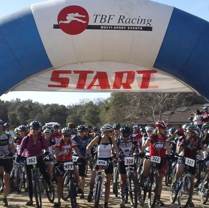
TBF RACING holds several MTB and combo race events on Granite Bay multi use trails this month. Heads up.
For the full calendar of their race events, CLICK HERE.

--Jan. 4th
Total Body Fitness New Year’s Duathlon
Duathlon and 5k event at Granite Bay. Run uses Oak Beach, Granite Main, Mooney Ridge. Road bike course uses Granite Beach, Oak Beach, Doton’s Point, Beeks Bight.
North Granite closure until noon.

--Jan. 5th
Woodcreek Mountain Bike Team Simulated Race Event
Simulated race with start and finish at Granite Main. Granite Bay multi-use trail.

--Jan. 11th
Total Body Fitness IPA Trail Run
12 miler and 5k event at Granite Bay. Uses Granite Main, Mooney Ridge, Old County, Beek’s Bight and Doton’s Point.

--Jan. 12th
Total Body Fitness MTB Kickstart
Mountain biking event at Granite Bay. Course uses multi use trails from Granite Main to Old County, Oak Point, Beek’s Bight and Doton’s Point.

--Jan. 25th
Total Body Fitness Gumby 10k/5k/Duathlon Granite Bay. Run uses Granite Main, Oak Point, Old County, Beek’s Bight and Doton’s Point. Mountain biking on the multi-use trail.
​
--Jan. 26th
Total Body Fitness MTB Classic Granite Bay
Mountain biking event at Granite Bay. Course uses multi use trails from Granite Main to Old County, Oak Point, Beek’s Bight and Doton’s Point.

For more information all all TBF Racing events, call Mark Shaw 916-995-6676 or email  Mark@totalbodyfitness.com


   ​

Perfect hike for the holidays, then enjoy Nevada City

12/21/2019

 
Picture
Cascade Canal Trail is close to home, by Mary West.  

Temperatures are cool. The leaves changed color and fallen at our feet. We day hikers can come down out of the High Sierra and smell the earth closer to home. Nevada County has a few hidden gems for day hikers and one of them is the Cascade Canal Trail. This is actually several trails in one.
​
This 4.5-mile trail begins in Nevada City off Gracie Road near Banner Lava Cap Road. Parking is limited. From Interstate 80 east, take the exit for Highway 49 toward Grass Valley. Follow CA-49 N to Gold Flat Road. Take exit 185A from CA-49 N. Turn Right onto Gracie. The trail head is maybe 700 feet from the intersection with Banner Lava Cap Road. 

Dogs on leash are welcome. I love how a trail keeps my memories, much like a song. When I return to a trail I am reminded of who I was with, and what I was thinking on my last visit. Maybe it’s just me, but winter hikes excite me as much as flowers in spring. Fall leaves, thick moss, tiny mushrooms and watch out for banana slugs under foot. It's like a complete makeover of our outside world.

​Photo credit: Mary WestBack to the trail.
Much of the distance on this trail follows an NID canal, providing a level flat surface of native soil. You can extend this trek another three-quarters of a mile or so by adding the Orene Wetherall Trail. The sign is on the left of the canal trail. This side trail is a series of switchbacks down to a nice bench with a great spot for bird watching. The Noel Carter Loop Trail is located near the bench as well. Another nice diversion is Woodpecker Way Access Trail. Orene Wetherall Trail is an easy trail headed down but I would call it moderate on the way up. I enjoy the many trail dedications, and other trail notes along the way. It tells me someone cares about these places as much as I do.

Returning back to the Canal Trail you can turn right to the trail head or you can make a left and enjoy a nice view of the Nevada City area through the pines. The variety of conifers is delightful. If I had anything critical to say about this trail it would be the noise of a nearby outdoor shooting range, and this trail must be in the flight path of the airport. If you can tune those out, this is a fine trail to stroll on a winter day.
-------------------------------------------------------------

Mary West is author of the book series "Day Hiker: Gold Country Trail Guide." The books are a collection of the Day Hiker columns where West shares her longtime love of the outdoors, and favorite hikes in Northern California’s Gold Country and beyond (available on Amazon). West was a recipient of a 2017 and 2019 CRAFT Award for Best Outdoor Column by the Outdoor Writers of California. Follow West on Facebook and Instagram.

CLICK here to see the original article and photos.


Eldorado NF Renovation closing some camps and day use areas

12/20/2019

 
Picture
From Eldorado National Forest administration: Recreation Facility Renovation Project and Recreation Area Facility Upgrades Are Coming Soon. Please pardon our dust while we make some exciting improvements to recreation sites associated with the Sacramento Municipal Utility District’s Upper American River Project in El Dorado County. Over the next few years, many of the facilities will be upgraded, and several new features added for your future enjoyment. The work will require some sites to be temporarily or completely closed during construction within the timeframes below. We apologize for any inconvenience and thank you for your patience.
Schedule of improvements and temporary closures:
  • Schedule and Map (pdf)
2019 Renovations (Reopen in 2020)
  • Camino Cove Campground 
  • North Union Valley Road 
  • Wolf Creek Campground 
  • Lakeshore Drive (Ice House northshore past Strawberry Campground)
  • Northshore RV Campground
  • Slab Creek Reservoir (Not on map)
2020Pacific Ranger District, Crystal Basin Recreation Area
  • Construction of the Union Valley Bike Trail Phase 1- this will be an extension of the trail from Wench Creek to Yellowjacket.  Partial closures/controlled traffic are anticipated for Wench Creek CG and Yellowjacket CG & Boat Launch
  • New toilets will be installed at Buck Island Reservoir off of the Rubicon 4x4 Trail.  No closures are anticipated at this time.
Placerville Ranger District
  • Construction of Slab Creek boating run take out
  • Brush Creek Reservoir Boat Launch Development
Notes
  • Closures are subject to change.
  • Please check with the U.S. Forest Service for updates.


CLICK HERE for original press release from Eldorado National Forest.

CLICK HERE to access PDF of map and closures

Truckee Dirt Fondo, a MTB and e-bike race on Tahoe National Forest roads

12/19/2019

 
Picture
"The Truckee Dirt Fondo is a wild ride into the gravel and dirt roads of majestic Tahoe National Forest." - Bike Monkey

Truckee will host the third Truckee Dirt Fondo with Bike Monkey on June 13, 2020. The race will consist of three routes, taking participants as high as 8,006 feet over Sardine Peak through Tahoe National Forest.

The medium route will consist of 58.15 miles with 4,117 feet of elevation gain. The long route will take riders on a 65.12 mile adventure with 5,148 feet of elevation gain. It will also feature a new e-bike category, kids ride and a post-race festival.

E-bikes are officially permitted to compete in their own rank.
​
Photos courtesy Bike Monkey
CLICK HERE for the original article and photos in the Tahoe Weekly newspaper.

For more information, CLICK HERE for more information on the race.
Picture

Widespread Pile Burning today through Thursday on the Tahoe National Forest

12/4/2019

 
Picture
Nevada City, Calif. – The US Forest Service will conduct several prescribed hand, grapple, and machine pile burns across the Tahoe National Forest this Tuesday through Thursday, 12/3/19-12/5/19, and possibly continuing into the weekend.  
The locations of these prescribed pile burns on the Tahoe National Forest include:

West Side (Highway 20 and 49 corridor; Foresthill, French Meadows; Downieville; Camptonville)
Sugar Pine Reservoir
Forks House Nature Trail
Mitchell Mine Road
Foresthill administrative sites
Big Trees day use area
North Bloomfield/Graniteville rd. east of Malakoff diggings
Marysville Road/Pendola (possible)
East Side (Highway 89 corridor; Donner Summit; Truckee; Sierraville)
Lake of the Woods
North-east of Independence Lake North-east Alder Creek Road

The overall goal of all prescribed fires within the Tahoe National Forest is to decrease the amount of fuels available to burn during a future wildfire. Other benefits include enhancing wildlife habitat and natural systems by reintroducing fire into a fire-dependent ecosystem.  Reducing hazardous fuels through prescribed fire activities is the most effective and cost-efficient treatment that influences future fire behavior and suppression success while also increasing forest health.


Fall, winter, and spring bring cooler temperatures and precipitation, which favor prescribed burning. Each prescribed fire operation follows a prescribed fire burn plan that considers temperature, humidity, wind, moisture of the vegetation, available personal, and conditions for the dispersal of smoke. This information is used to decide when and where to burn.  The Tahoe national Forest strives to provide as much advance notice as possible before prescribed fire activities, but some operations may be conducted on short notice.  Fire personnel closely patrol prescribed fire areas during ignition and for several days after.
 Smoke from prescribed fire operations is normal and may continue for several days after an ignition depending on the project size and environmental conditions. Smoke may settle into the valleys in the evening and lift in the morning. The Tahoe National Forest coordinates with state and local county air pollution control districts and monitors weather conditions closely before prescribed fire ignition. Crews also conduct test burns before igniting a larger area to verify how effectively fuels are consumed and how smoke will travel. 

To see complete article in YUBANET.NET, click here.


    Archives

    March 2023
    February 2023
    January 2023
    December 2022
    November 2022
    October 2022
    September 2022
    August 2022
    July 2022
    June 2022
    May 2022
    April 2022
    March 2022
    February 2022
    January 2022
    December 2021
    November 2021
    October 2021
    September 2021
    August 2021
    July 2021
    June 2021
    May 2021
    April 2021
    March 2021
    February 2021
    January 2021
    December 2020
    November 2020
    October 2020
    September 2020
    August 2020
    July 2020
    June 2020
    May 2020
    April 2020
    March 2020
    February 2020
    January 2020
    December 2019
    November 2019
    October 2019
    September 2019
    August 2019
    July 2019
    June 2019
    May 2019
    April 2019
    March 2019
    February 2019
    January 2019
    December 2018
    November 2018
    October 2018
    September 2018
    August 2018
    July 2018
    June 2018
    May 2018
    April 2018
    March 2018
    February 2018
    January 2018
    December 2017
    November 2017
    October 2017
    September 2017
    August 2017
    July 2017
    June 2017
    May 2017
    April 2017
    March 2017
    February 2017
    January 2017
    December 2016
    November 2016
    October 2016
    September 2016
    August 2016
    July 2016
    June 2016
    May 2016
    April 2016
    March 2016
    February 2016
    January 2016
    December 2015
    November 2015
    October 2015
    September 2015
    August 2015
    July 2015

    Categories

    All

    RSS Feed

Home
Contact
 Mother Lode Trails is YOUR local volunteer-run trail information and resource website. Here you can find
up-to-the minute information on trail alerts, links and trail news for Placer,  Yuba, and Nevada counties.
Mother Lode Trails is trademarked.