MOTHER LODE TRAILS
  • Home
  • About
  • Contact
  • Volunteer
  • Links
    • Law Enforcement Emergency
    • Federal, State, County Districts Parks & Trails
    • Running Clubs
    • Equestrian Clubs
    • Mt. Bike Clubs
    • Hiking Clubs
    • Trail Advocacy Organizations
    • Phone Numbers State & Federal Parks, Trails & Lands
    • Lost & Found on the Trails
    • Where to Eat on the Trails
  • News
  • Alerts

American River and Sacramento park Labor Day restrictions, increased fees

8/30/2017

 
Picture
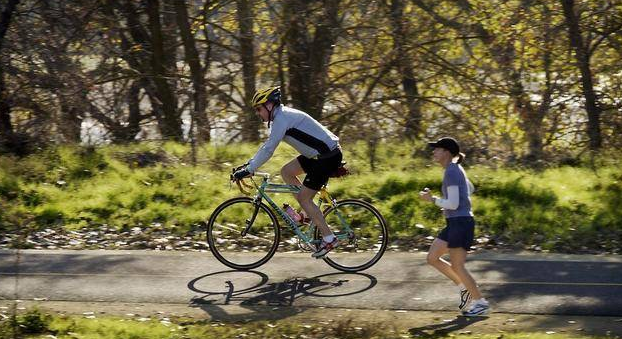
Alcohol Prohibited for the Holiday Weekend:
  • ​ Beginning Saturday, Sept. 2 through Monday, Sept. 4, possession of alcohol is prohibited on the shore and river of the American River within Sacramento County Regional Parks’ jurisdiction. The prohibition includes open or closed alcoholic beverages.
  • County Rangers will also continue to enforce the year-round alcohol restrictions from Paradise Beach to Discovery Park.
Prevent Wildfires:
  • ​All fireworks are prohibited in Regional Parks.
  • Smoking is only allowed in developed picnic areas, asphalt surfaces, golf courses and on levee tops in the American River Parkway.
  • Open flame fires are not allowed, and barbequing is only permitted in designated picnic areas.

Be Safe in the Water
  • ​Life Looks Good On You​—and so does a life vest! Before you dive in, put on a life vest. There are borrowing stations along Sacramento’s waterways and at local fire stations. Remember, even the strongest swimmer can be pulled under by the strong river currents.
  • Kids Don’t Float—but life vests do. Make sure your child wears a life vest. Sacramento County ordinance requires any child under 13 to wear a life vest before accessing any public waters (Sacramento County Ordinance 13.08.301). Bring a life vest for each of your children to the river.
  • Rivers are running especially fast and cold this weekend. Sacramento County recommends that people of all ages and abilities use caution when swimming or boating. Visit the Sacramento County’s Department of Regional Parks website about water safety tips.

Parking Fee Increase:
The number of visits to Regional Parks increases dramatically during holiday weekends, which increases the cost to staff and maintain the parks. In order to offset these costs and provide maximum staffing and enforcement, the vehicle entrance fee will increase to $8 for single vehicles and $13 for oversized vehicles and vehicles towing watercraft.

These increases will not affect annual pass holders. Visitors who regularly enjoy County Parks are encouraged to purchase an Annual Parks Pass, not only to save money but to help keep our parks safe and clean.

Visit the Sacramento County Regional Parks website for more information. For emergencies, 
​call 9-1-1.

American River Parkway: Dirt Trail Cycling Pilot Program Launches

8/29/2017

 
Picture
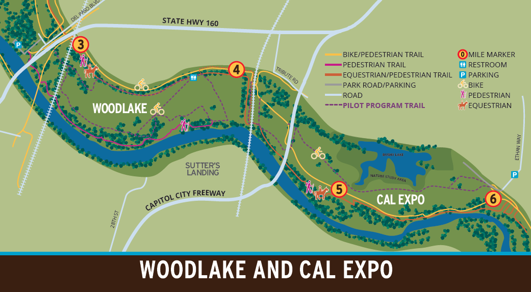
On September 8th, the Sacramento County Department of Regional Parks will open the Off-Paved Trail Cycling Pilot Program in the ​Woodlake and Cal Expo areas of the American River Parkway. Mountain bikers will be allowed to ride six miles of unpaved maintenance and fire roads in these areas during a trial period from September 2017 to 2020.

Mountain biking remains prohibited throughout the American River Parkway outside of the Woodlake and Cal Expo areas. 
The planning for the pilot program began with a public workshop with the American Ri​ver Parkway Advisory Committee that received public comment and discussion in February 2016.

The purpose of the pilot is to determine whether Off-Paved Trail Cycling can be an appropriate permanent use in the American River Parkway. After the three year trial period and evaluation, this pilot program may be made a permanent use with an Area Plan Map Amendment approved by the Board of Supervisors. 

Pilot trail map:​
  • ​Woodlake and Cal Expo Trails​ 

​Trail Rules:
  • ​Communicate your presence
  • Cyclists and hikers yield to equestrians
  • Stay on designated trails
  • Building features on​ trails is prohibited
  • No riding on wet trails
  • Obey all signs and barriers
  • Off-paved cycling is prohibited in the Parkway outside of the Woodlake and Cal Expo areas

Trail Surface:
  • ​Skill level: Easy
  • Average grade: </=5%
  • Obstacles: infrequent and insubstantial​

Join us for Opening Day at 9:00 a.m. on September 8th at the Cal Expo Overflow Parking Lot.

To see the original press release from Sacramento County, CLICK HERE.

Loney Meadow trails intermittent closures during September and October due to habitat restoration

8/25/2017

 
Picture
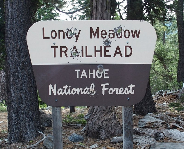
If you are planning to visit Loney Meadow during September and October, please expect to encounter limited parking and intermittent trail closures for specific sections of the trail around Loney Meadow.

Starting in late August and continuing through October, the South Yuba River Citizens League (SYRCL) and Tahoe National Forest (TNF) will be working to restore stream and wetland habitat across the 50-acre Loney Meadow. This project is part of a joint effort by SYRCL and the TNF to restore meadows within the Yuba River watershed to protect headwater streams that support water quality and supply, as well as wildlife and plant habitat throughout the region.

The Loney Meadow Restoration Project has three main goals:  (1) improve plant and wildlife habitat; (2) recharge groundwater; and (3) reduce stream erosion.

“This is a great opportunity to restore our important and rare alpine meadows,” said Karen Hayden, District Ranger for the Yuba River Ranger District. “While it will look messy during this restoration work, the end result will be a better, healthier meadow.”

This project is being completed in partnership with the U.S. Forest Service, SYRCL, National Fish and Wildlife Foundation, National Forest Foundation, Sierra Nevada Conservancy, California Department of Fish and Wildlife, Earthwatch, Nevada County, and UC Davis.

Located in the Grouse Ridge area, Loney Meadow is part of a larger meadow complex that drains into the Canyon Creek sub-watershed. Road building, fire suppression, and historic grazing and logging activities have heavily impacted meadows in the Sierra Nevada. In Loney Meadow, these activities have resulted in a downcut stream channel, destabilized stream banks, loss of habitat, lowered water table, and encroachment by non-native species. According to Rachel Hutchinson, River Science Director at SYRCL, “The benefit of restoring this meadow will allow us to reinstate resiliency to one of our most treasured ecosystems, while protecting our headwater resources.”

If you are planning to visit the area during September and October, please expect to encounter limited parking and intermittent trail closures for specific sections of the trail around Loney Meadow. Aslo, Bowman Road may be closed for repairs this fall; please check the Tahoe National Forest website for more information (www.fs.usda.gov/tahoe).

For more information on the Loney Meadow Restoration Project, please visit www.yubariver.org or contact:  Rachel Hutchinson, Science Director, SYRCL, rachel@syrcl.org or Luke Rutton, Hydrologist, Tahoe National Forest, lrutten@fs.fed.us.

To read the original press release from Tahoe National Forest CLICK HERE.


Everything you ever wanted to know about the new Hidden Falls reservation system and fees

8/24/2017

 
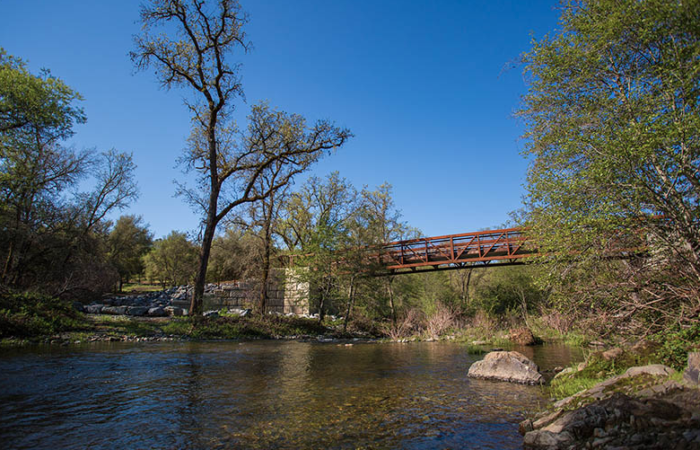
Picture
This complete Hidden Falls information comes from Lisa Carnahan, Placer County Parks Division, Senior Planner:

"During high volume days (weekends, holidays, and some Fridays) during  mild weather seasons (spring, early summer and fall) users will be required to pay $8.00 per vehicle for a full day reservation.  Except  for some holiday times, there will not be a charge Mondays through Thursdays.

You will get those reservations *before* arriving at the  park via an online calendar linked to our web site.  The calendar will  allow you to see which days require a reservation fee and secure  reservations up to 60 days in advance.

With a full day reservation,  you can arrive and leave any time you please within normal operating  hours (1/2 hour before sunrise to 1/2 hour after sunset).  From  experience, we know that the parking lot tends to thin out after about  2:30 in the afternoon even during days that experience overcrowded  conditions earlier in the day.  So, in order to allow people to take  advantage of space left after the parking lot naturally thins out, we  are prepared to issue a set number of partial day passes for $4.00 to  people wishing to arrive later in the day.  

We will adjust the number  of passes available as we observe parking trends once the new system is  up and running, trying to allow as many visitors as the parking lot can  comfortably hold.  However, we will also save a portion of the gravel  overflow area as a buffer in case there is more overlap between early  and late visitors than we expected, so that nobody with a reservation gets turned away.

The horse trailer area will be reserved in the same way as the automobile area (same prices during the same peak days), but it will  have its own separate quota of reservations to make sure the full  gravel horse trailer area is kept just for trailered vehicles. Equestrians will be able to reserve up to 10 parking stalls, either for a full day or for just the afternoon.  The 10 spots include mainly the equestrian gravel area but also is intended for a couple of spots in the overflow area.  

We have  high expectations that the net result of the new system will be a  happier experience for everyone who comes to the park, as well as those  who live around the entrance to the park, and that the overcrowding  problems will become the exception, few and far between.

We will be implementing the reservation system starting September 1st,  but will be giving the public a month's time to become familiarized  with using the reservation system with no fees associated.  Then on  October 15th, we will begin collecting fees during the peak times.  

The  fee/reservation system is not intended in any way to be a money-maker.   In fact, the revenues expected from parking fees is expected to be  under half of what it will cost to administer the program.  With the  popularity of this park, it is simply the most effective way to assure visitors of a parking space when they arrive and limit the traffic impact on park neighbors.  

I will be placing some information on our website for Hidden Falls, and on the FB  and Twitter pages that the Rangers keep current.

This reservation system is new to all of us, so we will be monitoring it closely during its break-in period in order to respond to necessary changes.  Once everyone has been accustomed to using the system, we hope to add other features such as monthly or annual passes, discounts for senior citizens, etc.  

Lastly, the hours for full days will be dawn  to sunset, and the afternoon, partial-day pass will be 2:30 - sunset.  The exact hours will change, depending on the length of day (longer hours in the summer and shorter hours in the winter)  but will be posted on the reservation paperwork.

Please feel free to contact me with any further questions, and to  forward the above information as well as my contact information to  anyone who may be interested.

Lisa Carnahan
Placer County Parks Division, Senior Planner
lcarnaha@placer.ca.gov
(530) 889-6837

Parking fees for Hidden Falls Park during peak times, new online reservation system coming in September

8/16/2017

 
Picture
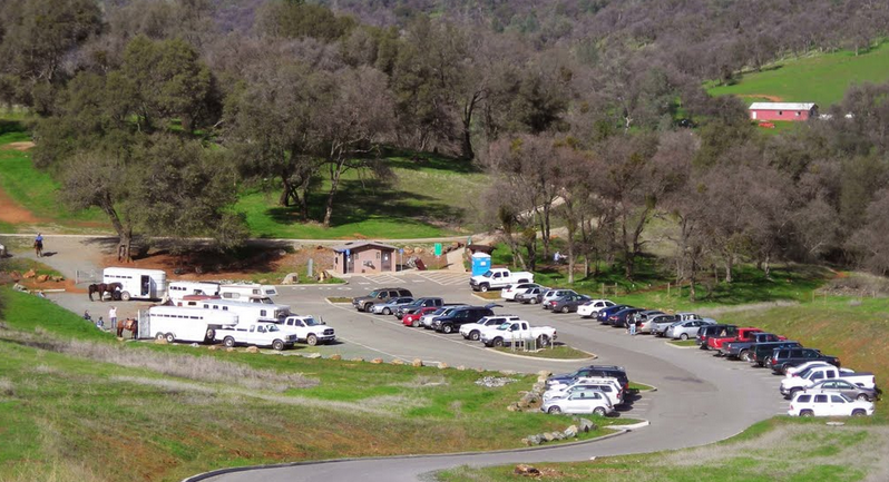
Placer County’s Hidden Falls Regional Park in North Auburn is a gem of a park. Unfortunately, parking can be hard to find, especially during weekends, holidays and times of mild weather, which is often.

To help avoid would-be park visitors from being turned away, the Placer County Board of Supervisors today approved a new parking fee during times of peak visitation.

Beginning in September, Hidden Falls visitors will be able to reserve a parking spot and pay the fee, when it’s required, using a new online reservation system. Reservations for all other county park facilities will also be managed through the system.

Hidden Falls parking fees will be $8 per vehicle per day for peak times (8:30 a.m. - 2:30 p.m.),  when visitors to the park are often unable to find parking and are forced to change plans and leave; the fee will be $4 for partial days, outside peak hours. No fee will be required during off-peak times when the parking lot does not normally fill up.

“It is our hope that the new reservation system will help increase the number of visitors enjoying the park and avoid the frustration of being turned away,” said Placer County Parks and Recreation Director Andy Fisher.

The proposed fee is comparable to the current $10 per day fee for use of the nearby Auburn State Recreation Area that is managed by California Department of Parks and Recreation.

The board’s approval also authorizes the county to enforce parking violation fines of $25 for first time infractions and $100 for repeat offenders.

The fees and fines, in combination with the parking restrictions implemented in the areas bordering the park, are also intended to reduce traffic impacts to surrounding neighborhoods.

County staff will return to the board at a later date to reevaluate the parking fee program and further explore the possibility of discounts for members of our military community.

CLICK HERE to see the original article on the Placer County website.

Forest thinning to close Pope-Baldwin bike path near South Lake Tahoe

8/6/2017

 
Picture
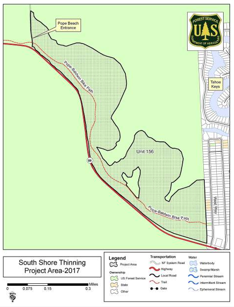
Efforts to reduce vegetation are slated to continue on National Forest lands near South Lake Tahoe, according to the U.S. Forest Service.
The mechanical cut-to-length (CTL) tree removal started this week and will continue on approximately 100 acres near the Pope-Baldwin Bike Path bike path. It is expected to continue through mid-October, weather permitting.
Thinning will take place in Unit 156, which is located adjacent to Highway 89 and the path.
USFS expects to issue a forest order temporarily closing the bike path for approximately two weeks.
The Forest Service will post closure signs in the area and the forest order will be posted online at http://bit.ly/2tvaaPB when it becomes available.
CTL thinning involves using a harvester to cut the tree down, remove the limbs and cut the tree into sections in the cutting area. For public safety, USFS advises people to avoid these areas due to the hazards posed by heavy equipment and falling trees. Hazards may be present even when operations have ceased for the day.
--
To see the original article and photos in the Tahoe Daily Tribune Newspaper, CLICK HERE.

The oldest and most famous 100 mile endurance ride, the Tevis Cup, on the Western States Trail this weekend

8/4/2017

 
Picture
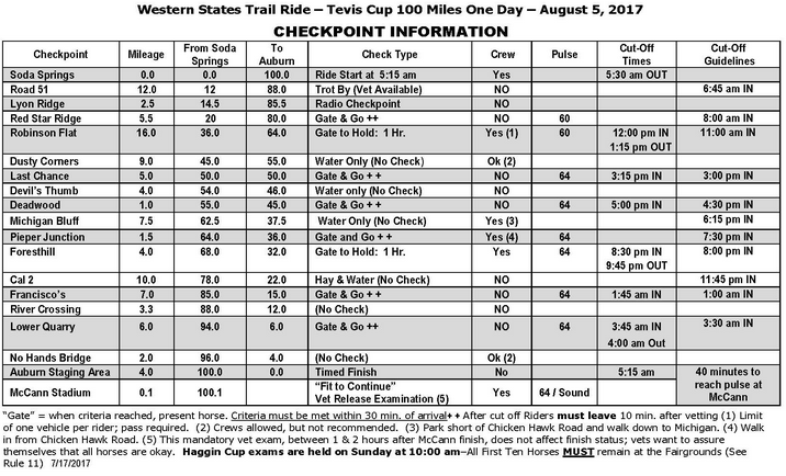
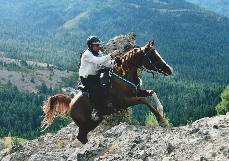
The Western States Trail Ride, popularly called the Tevis Cup Ride, is the oldest modern day equestrian endurance ride, having been held annually since 1955. As such, it has been the inspiration and model for the most challenging endurance rides worldwide.

The Tevis Cup Ride follows a rugged portion of the Western States Trail which stretches from Salt Lake City, Utah, to Sacramento, California. Normally, the ride starts at the Robie Equestrian Park (elevation 7,000 feet), south of Truckee, California, This year because of late snow, they will start at Soda Springs. For the exact route, go HERE. The trail descends gradually approximately nine miles to the Truckee River at the Midway Crossing on Highway 89. The trail takes a route through Squaw Valley, the U.S. Olympic training facility and site of the 1960 Winter Olympics, and ascends from the valley floor (elevation 6,200 feet) to Emigrant Pass near Watson's Monument (elevation 8,750 feet), a climb of 2,550 vertical feet in 4½ miles. From the pass, following the trail once used by gold and silver miners during the 1850s and rediscovered by Robert Montgomery Watson in 1929, riders will travel west, ascending another 15,540 feet and descending approximately 22,970 feet before reaching the century-old town of Auburn via the traditional route through Robinson Flat, Last Chance, Deadwood, Michigan Bluff, Foresthill, and Francisco's.

Much of this historic route passes along narrow mountain trails through remote and rugged wilderness territory. Participants who are unfamiliar with this area should use caution, especially in the high country and the route out of Foresthill to Francisco's. MUCH OF THIS TERRITORY IS ACCESSIBLE ONLY ON FOOT, ON HORSEBACK, OR BY HELICOPTER. 

Due to the remoteness and inaccessibility of the trail, the Tevis Cup Ride differs substantially from other organized endurance riding events. Adequate physical training and preparation for both horse and rider are of the utmost importance. The mountains, although beautiful, are relentless in their challenge and unforgiving to the ill-prepared.

The ride starts at in Soda Springs 5:00 AM Saturday, August 5, and continues through 5:00 AM Sunday where the riders finish in Auburn Fairgrounds. But, riders and their support crews are are traveling up to Soda Springs this week and today, Friday, August 4.

PLEASE, anyone who is not a participant or support crew for this ride, STAY OFF THIS TRAIL THIS WEEKEND. If you would like to know more and where you can see the brave riders and horses compete, go to the website HERE.
Picture

Starting August 4 - hundreds of grazing goats at Hidden Falls

8/3/2017

 
Picture
On Friday, August 4th, Hidden Falls Regional Park will be visited by hundreds of grazing goats for weed control within the park and will be staying for a few weeks. The Hidden Falls personnel is asking trail users not to touch the goats or the temporary fence lines.

To find out more information about Hidden Falls Regional Park, to see the webcam and and to sign up for their updates, CLICK HERE.

Two big run events in Tahoe-Truckee this weekend

8/3/2017

 
Picture
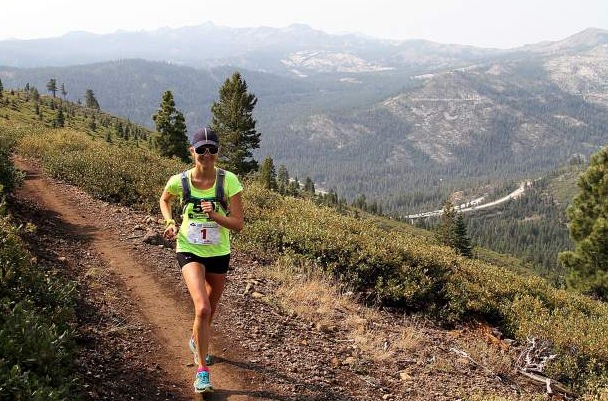
Runners in the Truckee-Tahoe region will have plenty of options for competing this weekend with a pair of events slated for Saturday, Aug. 5, ranging from a 5,000-foot ascent to a 50-kilometer ultra marathon.

Ascent Runs will host the finale of the three-part Tahoe Dirt & Vert Series with a race featuring more than 5,000 feet of climbing from Carson City, Nevada, up to Snow Valley Peak above Lake Tahoe, and then back to the finish line at Carson City; while in Truckee, Tahoe Mountain Sports will host the third annual Sierra Crest 50K and 30K Ultra Run and 15K Fun Run.

The Sierra Crest Ultra Run will benefit the Auburn Ski Club's Training Center Biathlon Programs.
The 30-kilometer and 50-kilometer races start at Tahoe Donner's Alder Creek Adventure Center end at the Auburn Ski Club Training Center at Boreal Mountain Resort.
The 50-kilometer course features 4,660 feet of elevation gain and 4,125 feet of loss; while the 30-kilometer route has 3,493 feet of gain and 2,948 feet of loss.

The course will take runners on single-track trails between Truckee and Donner Summit.

If you are not a participant in these events, please take care on these trails.

Upcoming races:

Capital Climb — Saturday, Aug. 5
Marlette 50K — Sunday, Aug. 13
XTERRA Lake Tahoe Triathlon — Saturday, Aug. 19
Castle Peak 100 ­— Saturday, Aug. 26
Lake Tahoe Triathlon — Aug. 26-27
-----------
Photo Courtesy of Auburn Ski Club. To see the original article and photos in the Tahoe Daily Tribune newspaper, CLICK HERE

    Archives

    January 2023
    December 2022
    November 2022
    October 2022
    September 2022
    August 2022
    July 2022
    June 2022
    May 2022
    April 2022
    March 2022
    February 2022
    January 2022
    December 2021
    November 2021
    October 2021
    September 2021
    August 2021
    July 2021
    June 2021
    May 2021
    April 2021
    March 2021
    February 2021
    January 2021
    December 2020
    November 2020
    October 2020
    September 2020
    August 2020
    July 2020
    June 2020
    May 2020
    April 2020
    March 2020
    February 2020
    January 2020
    December 2019
    November 2019
    October 2019
    September 2019
    August 2019
    July 2019
    June 2019
    May 2019
    April 2019
    March 2019
    February 2019
    January 2019
    December 2018
    November 2018
    October 2018
    September 2018
    August 2018
    July 2018
    June 2018
    May 2018
    April 2018
    March 2018
    February 2018
    January 2018
    December 2017
    November 2017
    October 2017
    September 2017
    August 2017
    July 2017
    June 2017
    May 2017
    April 2017
    March 2017
    February 2017
    January 2017
    December 2016
    November 2016
    October 2016
    September 2016
    August 2016
    July 2016
    June 2016
    May 2016
    April 2016
    March 2016
    February 2016
    January 2016
    December 2015
    November 2015
    October 2015
    September 2015
    August 2015
    July 2015

    Categories

    All

    RSS Feed

Home
Contact
 Mother Lode Trails is YOUR local volunteer-run trail information and resource website. Here you can find
up-to-the minute information on trail alerts, links and trail news for Placer,  Yuba, and Nevada counties.
Mother Lode Trails is trademarked.