MOTHER LODE TRAILS
  • Home
  • About
  • Contact
  • Volunteer
  • Links
    • Law Enforcement Emergency
    • Federal, State, County Districts Parks & Trails
    • Running Clubs
    • Equestrian Clubs
    • Mt. Bike Clubs
    • Hiking Clubs
    • Trail Advocacy Organizations
    • Phone Numbers State & Federal Parks, Trails & Lands
    • Where to Eat on the Trails
  • News
  • Alerts

Californians can use new iPhone SOS emergency service without cell reception

11/25/2022

 
Picture
Picture
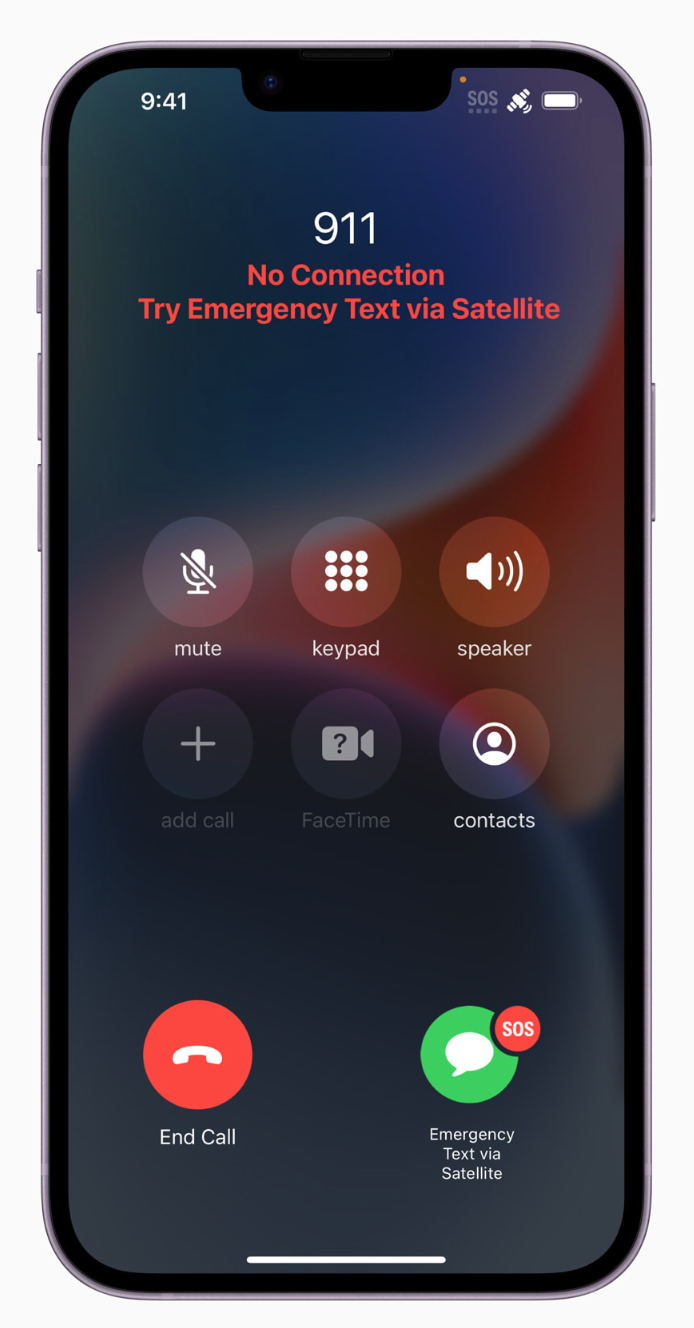
Especially important to trail users, iPhone 14 users can now connect with emergency services when cellular and Wi-Fi coverage are not available,

“Providing Emergency SOS via satellite is an important breakthrough that will save lives. The critical work being done by Apple to create innovative new solutions to support 911 providers and first responders is a huge step forward in protecting Californians and the broader public during an emergency situation,” said Mark Ghilarducci, the California Governor’s Office of Emergency Services’ director.

Apple announced its groundbreaking safety service Emergency SOS via satellite is now available to customers in the US and Canada. Available on all iPhone 14 models, the innovative technology enables users to message with emergency services while outside of cellular and Wi-Fi coverage. Additionally, if users want to reassure friends and family of their whereabouts while traveling off the grid, they can now open the Find My app and share their location via satellite. Emergency SOS via satellite is available in the US and Canada starting November 15.

"Emergency SOS via satellite is a breakthrough service available only on the iPhone 14 lineup, and a new innovation that we hope will provide our customers some peace of mind.”

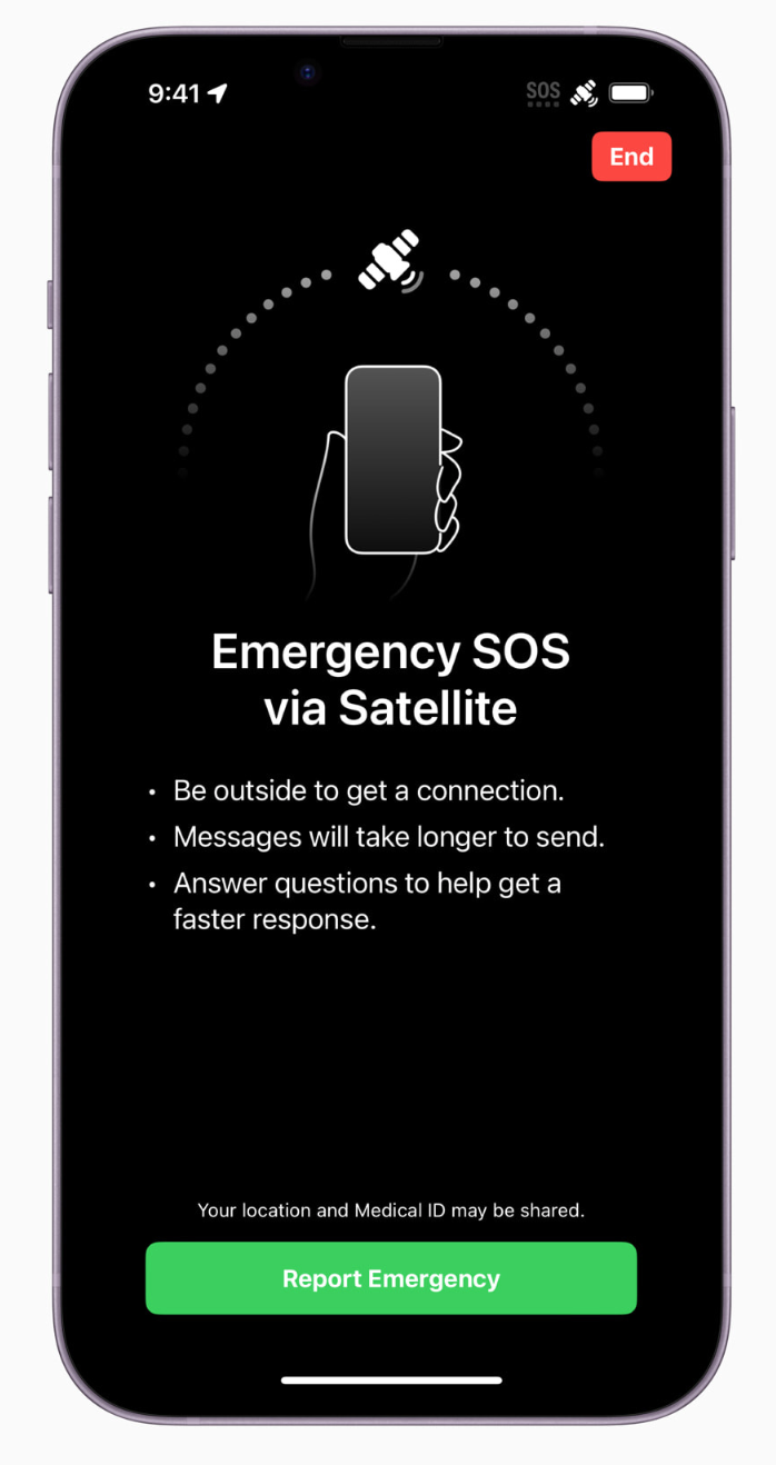
Every model in the iPhone 14 lineup — iPhone 14, iPhone 14 Plus, iPhone 14 Pro, and iPhone 14 Pro Max — can connect directly to a satellite through a combination of custom-designed components and deeply integrated software. Emergency SOS via satellite builds on existing features vital to iPhone users, including Emergency SOS, Medical ID, emergency contacts, and Find My location sharing, offering the ability to connect to a satellite for a more 360-degree approach to sharing critical information with emergency services, family, and friends. This game-changing service allows Public Safety Answering Points (PSAPs) — or emergency services call centers — to connect to even more users in emergency situations, and requires no additional software or protocols to enable communications. Users will be connected directly to emergency services that are equipped to receive text messages, or to relay centers with Apple-trained emergency specialists who are ready to contact PSAPs that cannot receive text messages on the user’s behalf.
​
To read more in Apple News, how this technology works and to see more images, CLICK HERE. 


Bear River Campground change to day use only

11/24/2022

 
Picture
- by Stacey Adams, Auburn Journal
  The California Department of Fish and Wildlife and Placer County Parks and Open Space hosted a town hall Monday to provide the public with an update on a possible memorandum of understanding (MOU) for the Bear River Campground.

Discussions regarding the campground’s future began after the county advised at the July 20 Weimar Applegate Colfax Municipal Advisory Council meeting it was considering not renewing the contract with Fish and Wildlife in order to focus resources on county-owned properties. The previous contract, which authorized the county to manage the campground, expired Nov. 12.

According to Placer County Parks Administrator Andy Fisher, the proposed MOU would be a one-year agreement - with a possible extension for a second year - for management of day use at the property, as the “loudest and clearest” comment received about the future of the campground was to not let service drop off at the contract’s end.

“What we wanted to do, not knowing the answer to a lot of the long-term questions about this property, we put together an MOU that will continue patrol, will continue restroom cleaning, will continue trash pickup, it’ll continue the ranger patrol service we’ve had over the past years with the intent that over the next two years, there will not be camping but day use only,” Fisher said.

Fisher confirmed patrols conducted by the Placer County Sheriff’s Office should remain unaffected, rangers onsite will have radio and cell contact with the Sheriff’s Office and wardens will have a presence to the extent of Fish and Wildlife availability. The MOU also includes Fish and Wildlife assuming responsibility in land and vegetation management, which Fisher said has begun.

Following the contract expiration, the county removed signage related to camping, picnic tables, fire pits and barbecues from the campground. Fisher and Kevin Thomas, regional manager for the Fish and Wildlife Region 2 office, confirmed the removals were conditions included in the prior agreement in the event Placer did not renew the contract.

“Whatever the future long-term decision about camping is, is not predetermined and it’s not going to be determined by our actions taking those things out,” Fisher said. “That was a compliance issue. If somebody comes along and there is camping in the future, they can be put back. Just want to emphasize that was not a statement of predetermination of what’s going to happen on that property going into the future.”

Thomas confirmed that while camping is “not in the Department of Fish and Wildlife’s wheelhouse for how we operate,” it will continue to work over the next couple of years with groups who may be able to host that function due to the public’s desire for camping, as well as general management of the property.

The town hall allowed the public to ask questions about what has taken place at the property and the MOU, as well as provide input.

Questions included whether the trails would be maintained and remain open, what area of the property will be open to the public for day use and if in-stream mining practices will be upheld or revert to “hands and pans only” requirements. Fisher confirmed trails are user-maintained and would remain open for day use, and mining would continue under current rules and regulations. Fisher also confirmed the only current change is the implementation of no camping.

Public input included returning the picnic tables for groups who utilized the tables for home study and looking into having a host live on the property to deter potential problems.

Fisher said the MOU will be presented to the Board of Supervisors on Tuesday, Nov. 29, and included in the meeting agenda, once posted, for the public to review. According to the calendar details for the meeting, the agenda is typically posted by 5 p.m. on the Wednesday before a board meeting.
​

The public can email placercountyparks@placer.ca.gov to be placed on the notification list for information or to submit comments and questions, Fisher said.

To see original article and photos in Gold Country Media:
https://goldcountrymedia.com/news/260470/short-term-plan-for-bear-river-campground-outlined-at-town-hall/

Thanks for our public Trails

11/24/2022

 
Picture

Fires from exploding e-bike batteries multiply — sometimes fatally

11/6/2022

 
Picture
Four times a week on average, an e-bike or e-scooter battery catches fire in New York City.

Sometimes, it does so on the street, or when the owner is recharging the lithium ion battery. The highly flammable electrolyte inside the battery's cells leaks out of its casing and ignites, setting off a chain reaction.

"These bikes when they fail, they fail like a blowtorch," said Dan Flynn, the chief fire marshal at the New York Fire Department. 

And these fires are getting more frequent.
As of Friday, the FDNY investigated 174 battery fires, putting 2022 on track to double the number of fires that occurred last year (104) and quadruple the number from 2020 (44). So far this year, six people have died in e-bike-related fires and 93 people were injured, up from four deaths and 79 injuries last year.

E-bike batteries are made up of numerous "cells," each a bit larger than a AA battery. If they are damaged and leak fluid, they can easily combust.
​
The FDNY says most batteries are so destroyed by fire when they inspect them that they can make no conclusions about which brand is safer than another.
The FDNY has begun posting videos on social media warning about the dangers of recharging lithium ion batteries.

This summer, the New York City Housing Authority proposed banning e-bikes and batteries from its 2,600 buildings. 

To see the original article and photos at NPR.org, CLICK HERE.
https://www.npr.org/2022/10/30/1130239008/fires-from-exploding-e-bike-batteries-multiply-in-nyc-sometimes-fatally

Tahoe National Forest resumes prescribed burning program

11/4/2022

 
Picture
NEVADA CITY, Calif. Nov. 4, 2022 — Tahoe National Forest plans to resume prescribed burning operations starting Nov. 4 across various locations on the forest as conditions allow. Recent storm activity has provided the moisture necessary to burn and resume critical fuels treatment work. Each planned burn project duration may vary on conditions and smoke dispersion could last several days.  
Upcoming prescribed burns include: 
  • Nov. 4, 2022 – Truckee near Glenshire and Greater Juniper Hills subdivisions. The project will pile burn 204 acres and reduce wildfire threat for over 1,400 homes in the area.  
  • Nov. 4, 2022 – Talbot Campground near French Meadows Reservoir. This project will pile burn 100 acres as part of the French Meadows Forest Restoration Project undertaken with several partners and consists of over 22,000 acres of identified fuels treatment activities. 
  • Nov. 5, 2022 – Burlington Ridge Road, south of White Cloud, which will pile burn 90 acres. 

Fall and winter typically bring cooler temperatures and precipitation, which can be ideal for conducting prescribed fires. With that, each operation follows a specialized burn plan, wherein temperature, humidity, wind, vegetation moisture and smoke dispersal conditions are considered daily before a prescribed fire is implemented. All this information is used to decide if and when to burn.   

“Prescribed fire plays a critical role in reducing the risk of catastrophic wildfire impacting our communities that interface with the Tahoe National Forest,” said Tahoe National Forest Acting Forest Fire Management Officer Kyle Jacobson. “We are fully committed to safely using this important tool to reduce wildfire risk, while simultaneously working towards creating healthy and resilient landscapes for the public to enjoy.” 

Smoke from prescribed fire operations is normal and may continue for several days after an ignition depending on the project size, conditions and weather. Prescribed fire smoke is generally less intense and of much shorter duration than smoke produced by unwanted wildfires, as fire managers consider optimal conditions for dispersal and duration of smoke impacts when considering prescribed burns. 
Prescribed fires are part of vital fuels reduction efforts aiming to reduce the severity of future wildfires, restore forest health and diversity, and provide added protection for surrounding communities. Fuels treatments help promote a more ecologically balanced and resilient forest and improve habitat for wildlife.   
​

Prescribed burns are resuming on the Tahoe National Forest following a 90-day national pause. The pause, necessitated by recent escaped prescribed fires, was enacted by Forest Service Chief Randy Moore on May 12, 2022. The pause was conditionally lifted on September 8, 2022 after a thorough national program review. Prior to burning, units on all National Forest System lands must implement a series of recommendations to ensure the safety and success of the prescribed burn. The Tahoe National Forest has successfully implemented these recommendations and will conduct prescribed burns as conditions permit. 

To see the original article in Yubanet.com, CLICK HERE.

    Archives

    May 2023
    April 2023
    March 2023
    February 2023
    January 2023
    December 2022
    November 2022
    October 2022
    September 2022
    August 2022
    July 2022
    June 2022
    May 2022
    April 2022
    March 2022
    February 2022
    January 2022
    December 2021
    November 2021
    October 2021
    September 2021
    August 2021
    July 2021
    June 2021
    May 2021
    April 2021
    March 2021
    February 2021
    January 2021
    December 2020
    November 2020
    October 2020
    September 2020
    August 2020
    July 2020
    June 2020
    May 2020
    April 2020
    March 2020
    February 2020
    January 2020
    December 2019
    November 2019
    October 2019
    September 2019
    August 2019
    July 2019
    June 2019
    May 2019
    April 2019
    March 2019
    February 2019
    January 2019
    December 2018
    November 2018
    October 2018
    September 2018
    August 2018
    July 2018
    June 2018
    May 2018
    April 2018
    March 2018
    February 2018
    January 2018
    December 2017
    November 2017
    October 2017
    September 2017
    August 2017
    July 2017
    June 2017
    May 2017
    April 2017
    March 2017
    February 2017
    January 2017
    December 2016
    November 2016
    October 2016
    September 2016
    August 2016
    July 2016
    June 2016
    May 2016
    April 2016
    March 2016
    February 2016
    January 2016
    December 2015
    November 2015
    October 2015
    September 2015
    August 2015
    July 2015

    Categories

    All

    RSS Feed

Home
Contact
 Mother Lode Trails is YOUR local volunteer-run trail information and resource website. Here you can find
up-to-the minute information on trail alerts, links and trail news for Placer,  Yuba, and Nevada counties.
Mother Lode Trails is trademarked.