MOTHER LODE TRAILS
  • Home
  • About
  • Contact
  • Volunteer
  • Links
    • Law Enforcement Emergency
    • Federal, State, County Districts Parks & Trails
    • Running Clubs
    • Equestrian Clubs
    • Mt. Bike Clubs
    • Hiking Clubs
    • Trail Advocacy Organizations
    • Phone Numbers State & Federal Parks, Trails & Lands
    • Lost & Found on the Trails
    • Where to Eat on the Trails
  • News
  • Alerts

USDA Forest Service closing ALL California National Forests through Sept. 17

8/31/2021

 
Picture
USDA Forest Service Temporarily Closing All California National Forests for Public Safety Release Date: Aug 30, 2021

VALLEJO, Calif., — August 30, 2021.  To better provide public and firefighter safety due to the ongoing California wildfire crisis, USDA Forest Service Pacific Southwest Region is announcing a temporary closure of all National Forests in California. This closure will be in effect from Aug. 31, 2021 at 11:59 p.m. through September 17, 2021 at 11:59 p.m. This order does not affect the Humboldt-Toiyabe National Forest, which is not in the Pacific Southwest Region.

“We do not take this decision lightly but this is the best choice for public safety,” said Regional Forester Jennifer Eberlien. “It is especially hard with the approaching Labor Day weekend, when so many people enjoy our national forests.”

Factors that led to this decision include:

1. By temporarily reducing the numbers of people on national forests, we hope to minimize the likelihood that visitors could become entrapped on National Forest System lands during emergency circumstances.

2. The closure order will also decrease the potential for new fire starts at a time of extremely limited firefighting resources, and enhance firefighter and community safety by limiting exposure that occurs in public evacuation situations, especially as COVID-19 continues to impact human health and strain hospital resources.

3. Due to state-wide conditions, any new fire starts have the potential for large and rapid fire growth with a high risk to life and property. The Forest Service and our partners are absolutely doing all we can to fight these fires and will continue to do so, but the conditions dictate the need for this region-wide closure order.

4. Forecasts show that conditions this season are trending the same or worse as we move into late summer and fall.

5. Although the potential for large fires and risk to life and property is not new, what is different is that we are facing: (a) record level fuel and fire conditions; (b) fire behavior that is beyond the norm of our experience and models such as large, quick runs in the night; (c) significantly limited initial attack resources, suppression resources, and Incident Command Teams to combat new fire starts and new large fires; and (d) no predicted weather relief for an extended period of time into the late fall.

The following persons are exempt from this Order:

1. Persons with Forest Service Permit No. FS-7700-48 (Permit for Use of Roads, Trails, or Areas Restricted by Regulation or Order), specifically exempting them from this Order.

2. Any Federal, State, or local officer, or member of an organized rescue or fire fighting force in the performance of an official duty.

3. Persons with a Forest Service special use authorization for an electric transmission line, an oil or gas pipeline, communications site, or any other non-recreation special use.

4. Commercial recreational special-use permit holders and their customers are not exempt from this Order. However, commercial recreational special-use permit holders, under the terms and conditions of their permit, may access their permit areas to conduct administrative functions and to protect property and related assets. Recreation residence permit holders are not exempt from this Order.

5. Persons with a Forest Service non-special-use written authorization to conduct non-recreational activities, such as harvesting timber or forest products, or grazing livestock.

6. Owners or lessees of land, and residents of such private landholdings, to the extent necessary to access their land.

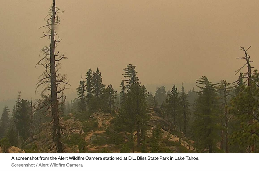
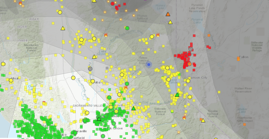
7. Persons engaged in a business, trade, or occupation are not exempt from the prohibitions listed above, but may use National Forest System roads to the extent necessary to carry out their business, trade, or occupation. More than 6,800 wildfires have burned 1.7 million acres across all jurisdictions in California, and the National Wildfire Preparedness Level (PL) has been at PL5 since July 14, 2021, only the third time in the past 20 years that the nation has reached PL 5 by mid-July – indicating the highest level of wildland fire activity.


The Forest Service thanks our partners and the public for their cooperation and understanding of this extreme public safety and fire threat. Citizens with specific questions within their area should consult their local forest website or social media pages for more information.

https://www.fs.usda.gov/detail/r5/news-events/?cid=FSEPRD949139

NID closes campgrounds and recreational facilities due to wildfire threat

8/25/2021

 
Picture
Due to fire risk and drought, the United States Forest Service has announced a temporary closure of the Tahoe National Forest (TNF). This closure will be effective at August 22, 2021 at 11:59 p.m. through September 6, 2021 at 11:59 p.m.

As a result, all NID campgrounds and recreational facilities in the TNF will be closed during this period. They will re-open on Sept. 7, 2021.

“Due to an unprecedented fire season and extreme drought, the U.S. Forest Service has placed a temporary closure order on the Tahoe National Forest. This will affect NID’s facilities,” said NID Recreation Manager Monica Reyes.

NID’s closed recreational facilities include campgrounds at the following locations: 
  • East Meadows
  • Pass Creek
  • Pass Creek Overflow
  • Aspen Group
  • Findley
  • Fir Tip
  • Woodcamp
  • Silvertip
  • Faucherie
  • Bowman
  • Jackson Creek
  • Canyon Creek
  • Milton
Additional closures include:
  • All boat launches and day use areas in the TNF
  • All dispersed camp area throughout the Bowman Corridor​
Faucherie photo from the NID website.

CLICK HERE to see the original article at Yubanet.com

Hidden Falls to close on days of extreme fire weather

8/21/2021

 
Picture
As part of our land stewardship and commitment to reducing wildfire risk, Hidden Falls Regional Park will be closed to public access during days that are determined to be extreme fire weather.

Notice will be given as far in advance of closure days as possible but may be as short as 12 hours’ notice before closure the following day.  Please check the status by clicking this webpage immediately before leaving on your visit to Hidden Falls this summer, or by calling (530) 886-4901 or by checking our Facebook page and other social media sites.

Visitors with reservations during closure days will be given credit for the purchase price of their reservation to be used for a future visit.  Thank you for your understanding in helping to keep Hidden Falls and its neighbors safe from wildfire.

USDA Forest Service Temporarily CLOSING Nine Northern California National Forests for Public Safety

8/20/2021

 
Picture
To better provide public and firefighter safety due to extreme fire conditions throughout northern California, and strained firefighting resources throughout the country, the USDA Forest Service Pacific Southwest Region is announcing a temporary closure of nine National Forests. This closure will be effective at August 22, 2021 at 11:59 p.m. through September 6, 2021 at 11:59 p.m.
​

“Fires are running very quickly due to the drought conditions, dry fuels, and winds. This makes initial attack and containment very difficult and is even more challenging with strained resources who are battling more than 100 large fires across the country,” said Regional Forester Jennifer Eberlien. “We do not take this decision lightly and understand how this impacts people who enjoy recreating on the National Forests. These temporary closures are necessary to ensure public and firefighter safety, as well as reduce the potential for new fire starts. I want to thank the public for your patience during this challenging situation.”

The closure order can be found at https://go.usa.gov/xF7EM. Affected forests include:
•Klamath National Forest
•Lake Tahoe Basin Management Unit
•Lassen National Forest
•Mendocino National Forest
•Modoc National Forest
•Plumas National Forest
•Shasta-Trinity National Forest
•Six Rivers National Forest
•Tahoe National Forest


The following persons are exempt from this Order:
  1. Persons with Forest Service Permit No. FS-7700-48 (Permit for Use of Roads, Trails, or Areas Restricted by Regulation or Order), specifically exempting them from this Order
  2. Any Federal, State, or local officer, or member of an organized rescue or fire fighting force in the Performance of an official duty.
  3. Persons with a Forest Service non-special-use written authorization to conduct non-recreational activities, such as harvesting timber or forest products, or grazing livestock.
  4. Owners or lessees of land, to the extent necessary to access their land.
  5. Residents, to the extent necessary to access their residences.
  6. Persons engaged in a business, trade, or occupation are not exempt from the prohibitions listed above but may use National Forest System roads to the extent necessary to carry out their business, trade, or occupation.

Additionally, the Eldorado National Forest is currently closed due to the Caldor Fire until Sept. 30 and has a separate list of exemptions. You can find more info here: https://www.fs.usda.gov/eldorado.

More than 6,500 wildfires have burned 1.2 million acres across all jurisdictions in California, and the Northern California Geographic Area has been at Preparedness Level 5 since Aug. 5, 2021 – indicating the highest level of wildland fire activity.

The Forest Service thanks our partners and the public for their cooperation and understanding of this extreme fire threat. Citizens with specific questions within their area should consult their local forest website or social media pages for more information.


About the Pacific Southwest Region:
The Forest Service manages 18 National Forests in the Pacific Southwest Region, which encompasses over 20 million acres across California, and assists forest landowners in California, Hawaii and the U.S. Affiliated Pacific Islands. National forests supply 50 percent of the water in California and form the watershed of most major aqueducts and more than 2,400 reservoirs throughout the state. For more information, visit www.fs.usda.gov/R5.
​
Public Inquiries: https://www.fs.usda.gov/main/r5/about-region/offices
Regional Hotline: 707-562-9113
SM.FS.R5inquiries@usda.gov


CLICK HERE to see the original post on the Reg. 5 webpage: www.fs.usda.gov/detail/r5/news-events/?cid=FSEPRD945706

CA State Parks Sierra District bans all campfires until December

8/18/2021

 
Picture
LAKE TAHOE Aug 18, 2021
Some of Lake Tahoe’s largest campsites have banned campfires entirely for the remainder of the season, officials at California State Park in the Sierra District said.
​
Fire restrictions have been in place across the Tahoe Basin since June, with many fire-fighting districts banning solid wood and charcoal firing in homes. On red flag days, fire restrictions are increased so no burns of any kind are allowed. 

The risk of fire is so great on these days that all types of open fires outdoors, including gas and propane grills, are prohibited.


Different guidelines apply at Forest Service campsites. A spokesman for the Forest Service’s Lake Tahoe Basin Management Unit said campfires and charcoal grills have been banned on their campsites since June.

Given the extreme fire hazard and arid forest conditions in Lake Tahoe, California State Parks will now introduce red flag level fire restrictions on their campsites for the remainder of the camping season. That means no campfires in the metal fire pits.

“Today we imposed a campfire ban with a red flag and given the preponderance of problems, weather, staff and major fires in [the] Region, the results of extreme fire conditions. The campfire ban will go beyond warning, ”said Dan Canfield, superintendent of the Sierra District of California State Parks, in an email to SFGATE on Tuesday.

Canfield said the ban would last through December “unless there is a significant improvement in conditions”. The bonfire ban will affect all campsites in the Sierra District, including Sugar Pine Point and DL Bliss state parks on Tahoe’s west bank and Donner Memorial State Park in Truckee.

Go HERE to see the original article and photos in the Nevada News Press.


Eldorado National Forest closed to all uses, Caldor Fire

8/18/2021

 
Picture
From: Jon Jue, District Resource Officer, Eldorado National Forest, Georgetown Ranger District

"Due to the Caldor Fire, the Eldorado National Forest is closed to all entry and uses for public safety. The Caldor Fire is growing rapidly and there is no estimate of containment. Please plan your recreation where it is safe."

EMERGENCY FOREST CLOSURE - Closed due to Emergency Forest Closure 03-21-14. See below.

CALDOR FIRE
  • Caldor Fire Information Line: (530) 303-2455
  • Caldor Fire Maps: inciweb.nwcg.gov/incident/maps/7801/
  • Facebook: www.facebook.com/eldoradonf
  • Twitter: twitter.com/EldoradoNF
  • Wildfire Cameras: www.alertwildfire.org/tahoe
  • Eldorado National Forest website  www.www.fs.usda.gov/eldorado/

jonathan.jue@usda.gov
p: 530-333-5550
7600 Wentworth Springs Road
Georgetown, CA 95634-9580
www.fs.fed.us
Picture

Dixie and River fire affecting our area with dangerous levels of smoke

8/9/2021

 
Picture
The Sierra is covered with dense smoke from our local fires. It has gone as high as over 500 AQI, meaning so dangerous it exceeds the measuring devices.

If you smell or see smoke at the trail head:
DO NOT hike or trail run.
DO NOT ride your horses.
DO NOT walk your dogs.
DO NOT go outside unless you must, and with a good medical grade mask on to filter out the dangerous particles that will harm your lungs.

Go here to see the current smoke map:
​https://fire.airnow.gov/?lat=39.38524000000007&lng=-120.52557999999999&zoom=12

TEVIS VOLUNTEERS AND RIDERS  - COVID ALERT!

8/2/2021

 
Picture
 ​To all who attended the 2021 Tevis Ride and took part in any of the activities before and after:
A person who attended the Tevis Cup Ride on July 24th contacted us to report they tested positive for Covid-19 on the morning of July 28th. 


This individual was at Robie Park, Foresthill, the finish line, and the Awards Banquet. This person had previously been vaccinated and has mild symptoms. Hopefully, this will not result in widespread problems.

If you experience any Covid-19 symptoms, no matter how minor, even if you are vaccinated - please get tested immediately.

Please report to us any additional cases you are aware of. 
You may contact me directly at <rjhmd@aol.com>
Jeff Herten, President
WSTF Board of Governors
Stay healthy,
Jeff Herten, MD
President, Western States Trail Foundation
Board of Governors
email: rjhmd@aol.com

Go to:
http://www.teviscup.org/node/298 for more information and updates

Positive plague tests results leads to recreation closures in South Tahoe

8/2/2021

 
Picture
SOUTH LAKE TAHOE, Calif. — Based on positive plague tests and planned vector control treatments, the Taylor Creek Visitor Center, Kiva Beach and their respective parking areas will be closed through Friday, officials announced this weekend.

The positive tests were found in chipmunks with no human contact, said El Dorado County spokesperson Carla Hass on Monday.

The Tallac Site, Kiva picnic parking area will remain open and visitor center staff and volunteers will be at the Tallac Historic Site. The Forest Service said vector control will complete its eradication treatments on Thursday and the areas will likely be reopened prior to the weekend.

According to El Dorado County Public Health, plague is naturally present in many parts of California, including higher elevations, and advises to be cautious around animals that can carry it.

“It’s important that individuals take precautions for themselves and their pets when outdoors, especially while walking, hiking or camping in areas where wild rodents are present,” said Public Health Officer Dr. Nancy Williams in a press release last year when a person was the first in five years in California to contract plague. “Human cases of plague are extremely rare but can be very serious.”

Plague is an infectious bacterial disease that is spread by squirrels, chipmunks and other wild rodents and their fleas. People can become infected through close contact with infected animals or the bite of an infected flea.

Officials say symptoms of plague usually show up within two weeks of exposure to an infected animal or flea and include fever, nausea, weakness and swollen lymph nodes. Plague can be effectively treated with antibiotics if detected early.

Plague can be prevented by avoiding contact with these rodents and their fleas, and by keeping pets away from rodents and their burrows. Human cases of plague are rare.
​
For more information about plague, visit the CDPH website.

To see the original article in the Tahoe Daily Tribune newspaper, CLICK HERE.


    Archives

    January 2023
    December 2022
    November 2022
    October 2022
    September 2022
    August 2022
    July 2022
    June 2022
    May 2022
    April 2022
    March 2022
    February 2022
    January 2022
    December 2021
    November 2021
    October 2021
    September 2021
    August 2021
    July 2021
    June 2021
    May 2021
    April 2021
    March 2021
    February 2021
    January 2021
    December 2020
    November 2020
    October 2020
    September 2020
    August 2020
    July 2020
    June 2020
    May 2020
    April 2020
    March 2020
    February 2020
    January 2020
    December 2019
    November 2019
    October 2019
    September 2019
    August 2019
    July 2019
    June 2019
    May 2019
    April 2019
    March 2019
    February 2019
    January 2019
    December 2018
    November 2018
    October 2018
    September 2018
    August 2018
    July 2018
    June 2018
    May 2018
    April 2018
    March 2018
    February 2018
    January 2018
    December 2017
    November 2017
    October 2017
    September 2017
    August 2017
    July 2017
    June 2017
    May 2017
    April 2017
    March 2017
    February 2017
    January 2017
    December 2016
    November 2016
    October 2016
    September 2016
    August 2016
    July 2016
    June 2016
    May 2016
    April 2016
    March 2016
    February 2016
    January 2016
    December 2015
    November 2015
    October 2015
    September 2015
    August 2015
    July 2015

    Categories

    All

    RSS Feed

Home
Contact
 Mother Lode Trails is YOUR local volunteer-run trail information and resource website. Here you can find
up-to-the minute information on trail alerts, links and trail news for Placer,  Yuba, and Nevada counties.
Mother Lode Trails is trademarked.