The Upper Union Trail (the north side of the Park across Highway 174) is completely blocked with multiple fallen trees. The first trees you will encounter are down across the uphill part of the trail.
|
The Upper Union Trail (the north side of the Park across Highway 174) is completely blocked with multiple fallen trees. The first trees you will encounter are down across the uphill part of the trail.
 (KTXL) — Placer County is adding several more miles of trails and a new parking lot to the popular Hidden Falls Regional Park, according to the county. Hidden Falls is located at 7587 Mears Place, Auburn and is open from dawn to dusk. On Tuesday, the county board of supervisors approved construction plans for the Twilight Ride Access and Parking/Trailhead Project at North Auburn Park. This expansion will provide access to 8 miles of new trails for hiking, cycling, running and horseback riding, a new parking lot and trailhead entrance off of Bell Road, improved signage and enhanced vegetation management. “We are excited to move this project forward while continuing to collaborate with park neighbors in order to minimize impacts on the surrounding areas,” said Placer County District 5 Supervisor Cindy Gustafson. “This project will provide a great opportunity for our community to get outside and enjoy the beauty of Placer County’s natural landscape.” Although the project will add more parking to what exists at the park already, the county will still have guests make online parking reservations “to ensure parking is available and to avoid overcrowding in the rural neighborhood.” Currently, Hidden Falls offers about 30 miles of multi-use trails, two observation decks for viewing the around 30-foot waterfalls, swimming areas and fishing access. To see the COUNTY Plan, EIR, etc. CLICK HERE To see this article at KXTL, CLICK HERE. 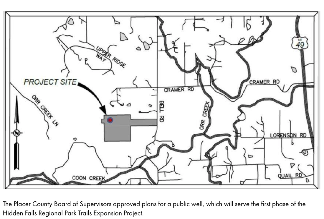  In July 2020, Hidden Falls Regional Park stopped requiring parking reservations for all days and limited that reservation requirement only on the weekends and high usage days, such as holidays.
April has become a high usage time, so be aware that you will need parking reservations from April 4 through Friday, April 14, 2023. For 2023, reservations are required on all weekends, but not weekdays. In addition, the following days during 2023 will require a parking reservation: 2023 High Usage Dates: 1/1, 1/16, 2/20, 4/3 – 4/14, 5/29, 7/4, 9/4, 10/9, 11/10, 11/23 - 11/24, 12/18 - 1/5. Parking reservations are required on all weekends, peak use days, and marked holidays. You’ll need to purchase your parking permit before your visit. Go here to purchase your parking permit (cost $4 half day, $8 full day): https://secure.rec1.com/CA/placer-ca/catalog There is a kiosk to check you in at the park and they will require the license number of your car and your horse trailer. To get more information: https://www.placer.ca.gov/6106/Hidden-Falls-Regional-Park 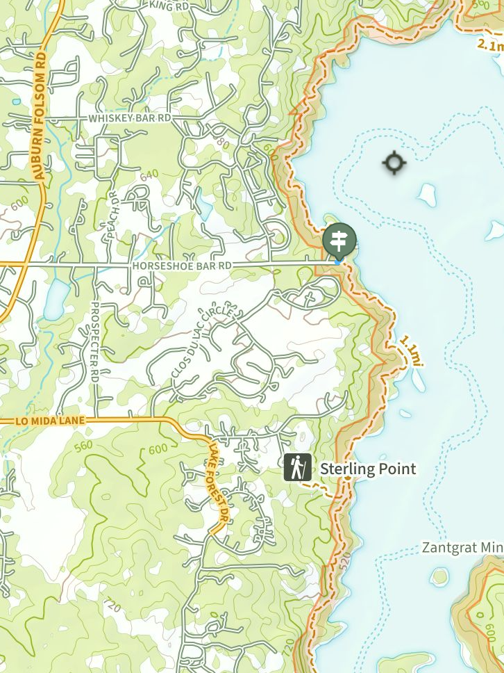 Posting from a Sterling Pointe trail runner:
I just came back from a run between Sterling and Rattlesnake. There are a couple of trees down, particularly between Sterling Pointe and Horseshoe Bar. It’s a mess. Ran into a couple of friends on horseback and it looks like they went down by the water from Sterling towards Horseshoe Bar, and then between Horseshoe Bar and Rattlesnake they had to take the saddle off one of the horses to pass under a tree. And, of course, it is mud city, at least for runners. Map screen shot from NaturalAtlas.com 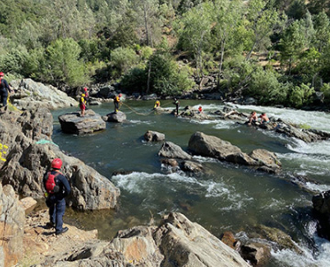 State Parks and CAL FIRE swift water teams rescue two stranded swimmers and a dog at Auburn State Recreation Area. Photo from California State Parks.
State Parks, Dept. of Water Resources and CAL FIRE urge the public to take extra precautions as snowmelt increases. With this season’s statewide snowpack at 237% of average as of April 3, California State Parks’ Division of Boating and Waterways (DBW), the Department of Water Resources (DWR) and the California Department of Forestry and Fire Protection (CAL FIRE) are urging the public to take extra precautions and to be aware of cold-water dangers this spring to avoid a tragedy. The series of winter storms is causing rising river and stream flow levels not seen in years. The eventual spring warm-up will bring fast flows and cold temperatures when all that snow starts to melt. All Californians are being encouraged to wait until summer to recreate in the water, when conditions are safer. “After successive low-water drought years, it is imperative that Californians understand water safety in and around rivers, streams, lakes and Sierra reservoirs,” said State Parks Director Armando Quintero. “As the temperature rises, snowmelt-fed waterways can quickly induce incapacitating cold-water shock to even the strongest swimmers. We encourage everyone to follow the advice of public safety officials and avoid entering waterways if asked to do so.” “California has one of the largest snowpacks on record,” said DWR Director Karla Nemeth. “As this snowpack melts in the coming months, the waterways will be especially cold, fast and running higher than normal. Be aware of fluctuating water levels. We want everyone to always make safety a top priority when recreating.” “This year is very different from the last several years, in that the excessive snowpack and rain will continue to create challenges for us in the weeks and months ahead. Rising water levels in rivers and streams will be very cold, very fast and can easily overwhelm those that aren’t prepared or don’t heed warnings,” said CAL FIRE Chief Joe Tyler. “Our teams will continue to focus on localized flooding risks, potential for major flooding, water rescues and our operational capabilities to support our communities moving into the spring and summer months.” All three departments hope to educate not only regular water enthusiasts but occasional visitors to high, fast-running waterways who may venture near the edge to test the water or take selfies. Just one slip or unwatched child can become a devastating drowning statistic. Here are some key safety points to know before heading outdoors: Plan Ahead
The public can find additional safety information at these weblinks:
Beyond its wildland firefighting role, CAL FIRE is an ”all-risk” department. It may very well be a CAL FIRE engine and crew that is dispatched to the scene of an auto accident, or to a home where a child has become the victim of a drowning incident. The Department is always ready to respond - medical aids; hazardous material spills; swift water rescues; search and rescue missions; civil disturbances; train wrecks; floods, earthquakes and more. We protect life and property from catastrophic events such as flood, drought, and dam or levee failure. Facebook I Twitter I Instagram I YouTube Subscribe to California State Parks News via e-mail at NewsRoom@parks.ca.gov California State Parks provides for the health, inspiration and education of the people of California by helping to preserve the state’s extraordinary biological diversity, protecting its most valued natural and cultural resources, and creating opportunities for high quality outdoor recreation. https://www.parks.ca.gov/NewsRelease/1163 Contacts: State Parks: Newsroom@parks.ca.gov I DWR: Media@water.ca.gov I CAL FIRE: CalFire.DutyPIO@fire.ca.gov  Due to heavy snowpack and near record wet weather conditions this winter, Tahoe National Forest has extended the seasonal closure period of its roads and trails to motorized use. Motorized vehicle use on forest roads during wet weather conditions causes degradation to soil and water resources. These actions will protect trails and roadbeds from damage during overly wet conditions, reduce maintenance costs and protect the quality of water, with much of the forest’s area serving a municipal watershed.
The use of motorized vehicles are prohibited as outlined below unless conditions allow for termination of the order on an earlier date: • April 1 through April 30, 2023, for roads and trails listed on the 2020 Tahoe National Forest Motor Vehicle Use Maps with Seasonal Designation dates of April 1 – December 31 (generally the westside of the forest), and • April 24 through May 23, 2023, for roads and trails listed on the 2020 Tahoe National Forest Motor Vehicle Use Maps with Seasonal Designation dates of April 24 – December 31 (generally the eastside of the forest). “Motorized use of forest roads and trails when soils are wet can cause an increase in damage to the road or trail surface, resulting in a loss of short- and long-term road or trail sustainability,” said Tahoe National Forest Trails Program Manager Joe Chavez. “Extreme wet weather events this season have saturated soils, with some forest roads and trails still inaccessible due to snowpack. This extended closure is so we can ensure the reduction of any adverse effects on resources. We appreciate our valued OHV operators’ patience during this time.” A minimum three-month closure period from January 1 through March 31 was designated for the core part of the wet season in the Tahoe National Forest Travel Management Plan. This plan also allows the seasonal road closure to start earlier or be extended based on conditions in a given year. Violation of the closure order is punishable by a fine of not more than $5,000 for an individual or $10,000 for an organization, or imprisonment for not more than 6 months, or both. View the Forest Order here. To see the original article in Yubanet.com, CLICK HERE. 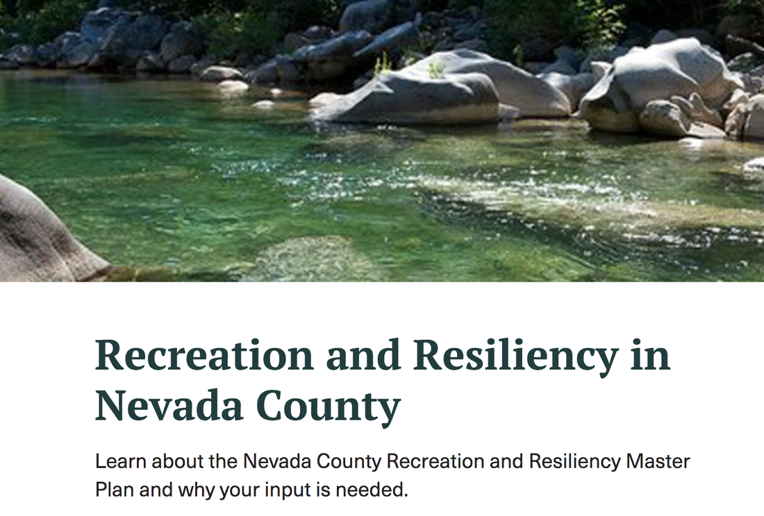 The County of Nevada invites the public to take a survey about how recreation can be improved throughout the county. The survey provides an opportunity to share concerns, hopes, and ideas for the future of recreation in Nevada County. Input from all community members is needed – including seniors, students, families, businesses, regional partners, and more.
MAKE YOUR VOICE HEARD, TAKE THIS NEVADA COUNTY SURVEY Nevada County Recreation & Resiliency Master Plan Survey Go here: <https://www.nevadacountyca.gov/3641/Recreation-and-Resiliency-Master-Plan> -> Under Project Timeline. -> Steps: 3 -> click on 1. "Take Survey" Project Purpose Nevada County has embarked on the creation of a countywide Recreation and Resiliency Master Plan - one of only a few efforts in the state and in the nation to proactively plan for natural disasters, a changing climate, and other stressors as part of designing our parks, trails, and open spaces. Take the Survey! This survey is the first opportunity for the public to participate in the development of the Nevada County Recreation and Resiliency Master Plan, led by the Nevada County Community Development Agency and consultants Design Workshop. The Master Plan will identify recreation needs and articulate a long-term vision for managing open spaces and recreation resources that range from local parks, playgrounds, sports fields, and facilities to rivers, trails, and outdoor access. Recommendations will identify projects that enhance recreation access, support health and safety, preserve natural resources, and increase economic vitality. Additionally, the Master Plan will address environmental and human-related impacts including, but not limited to, wildfires, natural disasters, drought, a changing climate, and increased visitation. Take the survey and learn more at http://www.NevadaCountyRecreation.com/plan To receive notifications on ways to participate and the latest information, please sign up at http://www.NevadaCountyCA.gov/Recreation |
Archives
April 2024
Categories |
 RSS Feed