The Salmon Falls Bridge Trail, also less commonly known as Darrington Trail, is an amazing hiking, biking and walking trail with stunning views of Folsom Lake.
Salmon Falls Bridge Trail (Darrington Trail) is located just 5.8 miles down Salmon Falls Rd. from Green Valley and El Dorado Hills, Blvd. Once you cross over Salmon Falls Bridge, the entrance to the Darrington trail will be on your immediate left across the street from the lower parking lot.
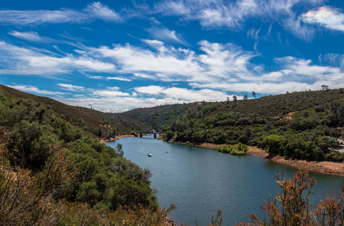
Salmon Falls Bridge Trail (Darrington Trail) is located just 5.8 miles down Salmon Falls Rd. from Green Valley and El Dorado Hills, Blvd. Once you cross over Salmon Falls Bridge, the entrance to the Darrington trail will be on your immediate left across the street from the lower parking lot.
- Location: El Dorado Hills, CA (Salmon Falls Bridge)
- Technical Level: Intermediate to Advanced (I would not recommend kids)
- Length: 10 Miles one-way (20 miles round trip)
- Dogs: Allowed on leashed (Some friendly dogs seen unleashed)
- Snakes: Watch out for Rattlesnakes in this area!
- Parking: 1. Before bridge on left, 2. Lower parking lot, 3. Uppper parking lot
- Fees: $10 Parking in Main Parking Lot, Free on Dirt
- Water: No water on trail, bring your own water
- Restrooms: 2 porta potties in parking lot below
- Picnic Tables: No Tables on immediate trail
- The Views: AMAZING!!
- Cliffs and Drop-Offs: There are many (be careful!)
- Best Time to Hike or Ride: February – April | September – October
- Local Trails Map: Folsom Lake Trails Map
- Darrington Trail Map: Salmon Falls Bridge (Darrington Trail) Map
- Salmon Falls Bridge follows the edge of the Folsom Lake Peninsula all the way to Peninsula Park. For the first couple of miles on this trail, you will be faced with treacherous cliffs and drop-offs. Some sections of the trail are very sketchy and have steep slopes while other sections are flat and easy to navigate. Just take your time in these sections of the trail and be courteous of other walkers, hikers and bikers coming in the opposite direction.
Once you get through the first section (1-2 miles), it gets much easier and everything flattens out. There used to be a paved road through some of these sections further into the trail. These paved roads have since deteriorated over time; however, you can still see the remains of them which makes for a pretty epic ride, walk or hike.
Several miles into the Salmon Falls Bridge (Darrington) Trail, you will come across fire roads that have a creek running through. Depending on what time of year you walk or ride the trail will determine whether or not there is water flowing through it.
There are many routes on the Salmon Falls Bridge (Darrington) Trail but they all end up at the same location; Peninsula Park.
Towards the End of The TrailAt the end of the trail, there is a four way intersection, head straight through and you will end up at Peninsula Park. Keep in mind that THIS TRAIL IS VERY HOT in the middle of summer. It is a must, that you bring your own water and keep your self well hydrated. Pack a backpack with frozen waters and cold waters, believe me, you will drink it all. Hopefully the frozen waters stay cold through your entire journey.
HAVE FUN and as always, be safe!
--Article Written By El Dorado Hills Resident Brenan Greene
Go HERE to see the original article and LOADS of pictures of this trail
 RSS Feed